Climate of the British Isles facts for kids
The British Isles are a group of islands off the northwest coast of Europe. They include Great Britain and Ireland, plus many smaller islands. Their location means that dry air from Eurasia meets wet air from the Atlantic Ocean. This makes the weather change a lot, sometimes many times in one day!
The climate here is called a temperate oceanic climate. This means it has warm summers and mild winters. It's usually warmer than other places at the same distance from the equator. This is because of the Rocky Mountains and how the North Atlantic Ocean holds heat.
Contents
Weather in the British Isles
Temperatures Throughout the Year
The British Isles usually have small changes in temperature. This is because they are close to the Atlantic Ocean. The ocean acts like a giant heater in winter and a cooler in summer.
Areas near the coast have more steady temperatures. Places further inland can have bigger temperature changes. Valleys can get very cold in winter because cool air sinks into them. July is usually the warmest month. The hottest temperatures are often found in south-east England, which is closest to Continental Europe.
Sunshine and Clouds
The sunniest months are usually May and June. December has the least sunshine. The clearest skies are often over the south of England. This is because of winds coming from the continent.
Mountainous areas, especially in the North-west, get very little sunshine. Sometimes they get less than 1000 hours a year. In winter, some north-south valleys might only see a few hours of sun each day.
Sometimes, a thick fog called radiation fog can form inland. It can last for hours or even days in winter. This fog can make driving and flying very dangerous. Fog is more common inland and in higher places, especially in winter mornings when the air pressure is high.
Sometimes, large high pressure systems can stay over the British Isles for weeks or even months. These systems often bring clear skies and few clouds. This means frosty nights in winter and hot, sunny days in summer. Some coastal areas can get almost constant sunshine during these summer periods.
Rain, Snow, and Hail
The amount of rain changes across the islands. Generally, it rains more as you go west and in higher places. December and January are usually the wettest months. The mountain ranges are the wettest areas in the U.K.
Most rain comes from storms called North Atlantic depressions. These happen all year, but are strongest in autumn and winter. They can bring long periods of heavy rain, and flooding is quite common.
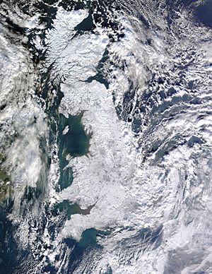
Snow can fall during the winter months, most often in January and February. Hail is also quite common, especially in summer. The 50 strongest hailstorms recorded in the UK since 1650 have all happened between May and September.
Winds
The main winds over the British Isles come from the west and south-west. Winds are strongest in the north and west. Coastal areas are usually windier than inland areas. The west is also windier than the east.
Gales are very strong winds. They are defined as winds blowing faster than 34 knots (about 39 mph or 63 km/h) for ten minutes. Gales often happen when deep storms pass over the area. The Hebrides islands typically have about 25 days with gales each year.
Extreme Weather Events
The British Isles do not often have extreme weather. However, there have been some unusual events. In the winter of 1982, parts of central and southern England were colder than central Europe or Moscow for a few days.
In contrast, the summers of 1975 and 1976 were very hot. Temperatures reached as high as 35 °C (95 °F). It was so dry that the country had a drought and water shortages. Long periods of extreme weather, like the droughts of 1975–1976 and 2022, or the very cold winters of 1946–1947, 1962–1963, 1978–79, 1981–1982, and 2009–2010, are often caused by blocking anticyclones. These high-pressure systems can stay in place for days or weeks. In winter, they bring long periods of cold, dry weather. In summer, they bring long periods of hot, dry weather.
Storms from Tropical Cyclones
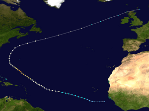
Tropical cyclones (like hurricanes) do not hit the British Isles directly. This is because the ocean around the islands is too cold. Any tropical cyclone that comes near the Isles changes into a different type of storm called an extratropical cyclone.
The British Isles do experience these strong extratropical cyclones. The Great Storm of 1987 was a very deep storm that formed near France. It even contained what was left of Hurricane Floyd. Hurricane Lili in 1996 and Hurricane Gordon in 2006 were strong extratropical cyclones. They brought winds as strong as a tropical storm, causing travel problems, power cuts, and flooding.
In 2011, the remains of Hurricane Katia brought very strong winds to Scotland. Sustained winds reached 70 mph (113 km/h) over the Isle of Lewis. In 2017, Hurricane Ophelia caused severe storms in Ireland. It also carried dust from the Sahara Desert and smoke from wildfires in Portugal into the air over the UK. This made the skies look red and orange across the country.
Thunderstorms
Thunderstorms are most common in London, the South-East, east of England, and the East Midlands. They are least common in the North-West. Areas like Greater London, Kent, Sussex, Essex, Hertfordshire, Cambridgeshire, Suffolk, and Norfolk have the most thunderstorms each year. The South-West and the West Midlands also get storms, but they are usually less severe.
Sometimes, thunderstorms can be very strong. They can produce large hailstones. For example, in Ottery St Mary, Devon in October 2008, hailstones piled up to 1.8 meters (nearly 6 feet) deep!
Climate Change in the British Isles
The Met Office (the UK's weather service) predicts changes for the future. They estimate that the average yearly temperature will increase by 2 °C (4 °F) by the 2050s. The warmest summer day is expected to get hotter by 3 °C (6 °F). Average winter rainfall is also likely to increase. Most areas will see a small decrease in the total amount of rain each year.
Recent Weather Records
In the early 2000s, the British Isles have seen some record-breaking weather events. From 2004 to 2006, a partial drought caused fires in southern Great Britain. Water use was restricted in some areas. The drought ended with a very wet period between October 2006 and July 2007, which had much higher than average rainfall.
The year 2006 was unusually warm. After a cool start, the weather stayed warmer than average from April onwards. July 2006 was the hottest month ever recorded in the United Kingdom at that time. (The summer of 2022 has since seen temperatures reach 40°C in some areas.)
|
 | John T. Biggers |
 | Thomas Blackshear |
 | Mark Bradford |
 | Beverly Buchanan |


