
Cherry Hill, New Jersey facts for kids
Quick facts for kids
Cherry Hill, New Jersey
|
||
|---|---|---|
|
Township
|
||

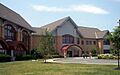
The Cherry Hill Public Library, one of the largest libraries in New Jersey, U.S., at 72,000 square feet (6,700 m2)
|
||
|
||
| Motto(s):
"You couldn't pick a better place"
|
||

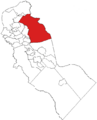
Location of Cherry Hill in Camden County highlighted in red.
|
||

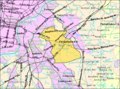
Census Bureau map of Cherry Hill, New Jersey.
|
||

Cherry Hill, New Jersey
Location in Camden County, New Jersey

Cherry Hill, New Jersey
Location in New Jersey

Cherry Hill, New Jersey
Location in the United States
|
||
| Country | ||
| State | ||
| County | Camden | |
| Incorporated | February 28, 1844, as Delaware Township | |
| Renamed | November 7, 1961, to Cherry Hill Township | |
| Named for | Cherry Hill farm | |
| Government | ||
| • Type | Faulkner Act Mayor-Council | |
| • Body | Township Council | |
| Area | ||
| • Total | 24.20 sq mi (62.67 km2) | |
| • Land | 24.07 sq mi (62.35 km2) | |
| • Water | 0.12 sq mi (0.32 km2) 0.51% | |
| Area rank | 114th of 565 in state 3rd of 37 in county |
|
| Elevation | 39 ft (12 m) | |
| Population
(2020)
|
||
| • Total | 74,553 | |
| • Estimate
(2023)
|
77,317 | |
| • Rank | 12th of 565 in state 1st of 37 in county |
|
| • Density | 3,097.1/sq mi (1,195.8/km2) | |
| • Density rank | 213th of 565 in state 24th of 37 in county |
|
| Time zone | UTC−05:00 (Eastern (EST)) | |
| • Summer (DST) | UTC−04:00 (EDT) | |
| ZIP Codes |
08002–08003, 08034
|
|
| Area code(s) | 856 | |
| FIPS code | 3400712280 | |
| GNIS feature ID | 0882155 | |

Cherry Hill is a township located in Camden County, New Jersey. It's a suburb of Philadelphia and is part of the Delaware Valley area. Cherry Hill grew a lot in the mid-1900s, becoming a major business hub, home to places like the Cherry Hill Mall. In 2020, about 74,553 people lived here.
Contents
History of Cherry Hill

How Cherry Hill Began
The land where Cherry Hill is today was first home to the Lenni-Lenape Native Americans. Later, in the late 1600s, Quaker settlers from England arrived. The first small group of homes was called Colestown.
The township was officially created on February 25, 1844. It was first known as Delaware Township. It became part of Camden County a few weeks later. Over time, some parts of the township became new towns like Merchantville and Pennsauken.
Why the Name Changed to Cherry Hill
The name "Cherry Hill" comes from a farm owned by Abraham Browning in the 1800s. This farm had many cherry trees. Later, the Cherry Hill Inn and other buildings were built on this land.
A developer named Eugene Mori used the "Cherry Hill" name for many of his projects, including the Cherry Hill Inn and the Cherry Hill Mall. The mall opened in 1961 and was the first enclosed shopping mall in the eastern United States.
When the township needed a new post office, another town in New Jersey was already using the name Delaware Township. So, the U.S. Postal Service asked for a new name. The people of the township voted, and "Cherry Hill" was chosen. The name officially changed on November 7, 1961.
Geography and Climate
Where is Cherry Hill?
Cherry Hill covers about 24.20 square miles (62.67 square kilometers). Most of this area is land, with a small amount of water.
Several communities are located within Cherry Hill, including Ashland, Barclay, and Springdale. The township shares its borders with other towns like Maple Shade Township, Evesham Township, and Mount Laurel Township. The Cooper River forms part of its southern border.
What's the Weather Like?
Cherry Hill has a mild climate with warm, humid summers and gentle winters. It gets a good amount of sunshine each year. Sometimes there's ice or snow in winter, but it usually melts quickly. The area can also be affected by Atlantic tropical storms. It rains a lot throughout the year.
| Climate data for Cherry Hill | |||||||||||||
|---|---|---|---|---|---|---|---|---|---|---|---|---|---|
| Month | Jan | Feb | Mar | Apr | May | Jun | Jul | Aug | Sep | Oct | Nov | Dec | Year |
| Mean daily maximum °F (°C) | 41 (5) |
46 (8) |
55 (13) |
66 (19) |
76 (24) |
86 (30) |
88 (31) |
86 (30) |
79 (26) |
68 (20) |
56 (13) |
46 (8) |
66 (19) |
| Mean daily minimum °F (°C) | 23 (−5) |
25 (−4) |
32 (0) |
41 (5) |
50 (10) |
60 (16) |
65 (18) |
63 (17) |
56 (13) |
44 (7) |
36 (2) |
28 (−2) |
44 (6) |
| Average precipitation inches (mm) | 3.90 (99) |
2.95 (75) |
4.17 (106) |
4.02 (102) |
4.36 (111) |
3.93 (100) |
4.84 (123) |
5.18 (132) |
4.17 (106) |
3.53 (90) |
3.51 (89) |
3.69 (94) |
48.25 (1,227) |
People and Population
| Historical population | |||
|---|---|---|---|
| Census | Pop. | %± | |
| 1850 | 2,577 | — | |
| 1860 | 1,602 | * | −37.8% |
| 1870 | 1,625 | 1.4% | |
| 1880 | 1,481 | * | −8.9% |
| 1890 | 1,457 | −1.6% | |
| 1900 | 1,679 | 15.2% | |
| 1910 | 1,706 | 1.6% | |
| 1920 | 2,331 | 36.6% | |
| 1930 | 5,734 | 146.0% | |
| 1940 | 5,811 | 1.3% | |
| 1950 | 10,358 | 78.2% | |
| 1960 | 31,522 | 204.3% | |
| 1970 | 64,395 | 104.3% | |
| 1980 | 68,785 | 6.8% | |
| 1990 | 69,348 | 0.8% | |
| 2000 | 69,965 | 0.9% | |
| 2010 | 71,045 | 1.5% | |
| 2020 | 74,553 | 4.9% | |
| 2023 (est.) | 77,317 | 8.8% | |
| Population sources:1850–2000 1850–1920 1850–1870 1850 1870 1880–1890 1890–1910 1910–1930 1940–2000 2000 2010 2020 * = Lost territory in previous decade. |
|||
Cherry Hill's population has grown steadily, especially since 2010. In 2020, it was the 12th most populated town in New Jersey and the largest in Camden County.
The number of Asian American residents in Cherry Hill is growing quickly. Many businesses owned by Korean Americans have opened along Route 70, with signs in Hangul (Korean writing).
Population in 2010
In 2010, Cherry Hill had 71,045 people living in 26,882 households. About 23% of the population was under 18 years old. The average age was around 43.1 years.
Economy and Jobs

Cherry Hill is an important place for businesses and jobs. TD Bank N.A.), one of the largest banks in the U.S., has its main office here. Melitta USA, a coffee company, also has a roasting plant in the township. The Courier-Post newspaper is published in Cherry Hill.
The Cherry Hill Mall was the first enclosed shopping mall in the eastern United States when it opened in 1961. Many people who live in Cherry Hill also work in nearby cities like Philadelphia, Camden, Trenton, or Princeton.
Places to Eat
Cherry Hill has many great places to eat. Chick's Deli is famous for its hoagies and cheesesteaks. You can also find many Korean restaurants along Marlton Pike (Route 70).
Community Life
Cherry Hill is home to Springdale Farms, the only working farm in the township. It's a special place that gets tax breaks because it's zoned for agriculture.
The Barclay Farm House was built in 1816 and is a historic building. It's now part of the Cherry Hill Arts Center, which offers art classes, workshops, and concerts for the community.
Sports and Recreation
Sports History
In the 1970s, the Cherry Hill Arena hosted a professional hockey team called the New Jersey Knights. Before that, another hockey team, the Jersey Devils, played there from 1964 to 1971.
Famous boxer Muhammad Ali lived in Cherry Hill with his family from 1971 to 1974.
Parks and Fun Places

Cherry Hill has over 50 public parks managed by the township, plus three parks owned by Camden County. Most parks have playgrounds, basketball courts, tennis courts, walking paths, and sports fields.
Croft Farm, built in 1753, was once a working farm and mill. It's now the Cherry Hill Arts Center, offering art classes and concerts.
Every April, you can see beautiful cherry blossoms along Chapel Avenue. This tradition started in 1972 when residents wanted to bring the community together. Cherry trees are still planted every year by volunteers.
Golf Courses
Cherry Hill has two private golf courses: Merchantville Country Club, a 9-hole course established in 1892, and Woodcrest Country Club, an 18-hole course founded in 1929.
Emergency Services
Police Department
The Cherry Hill Police Department (CHPD) is one of the largest police departments in the area. It has over 130 police officers and 21 civilian staff. The department has a special Tactical Response Team (TRT) for high-risk situations.
When you dial 9-1-1 in Cherry Hill, your call goes directly to the CHPD. This helps them respond very quickly. The police also have a Community Policing Unit that offers services like child fingerprinting and neighborhood watch programs.
Fire Department and EMS
The Cherry Hill Fire Department is a professional fire department. It also has two volunteer groups: the Cherry Hill Fire Police and the Special Services Unit ("Rehab 13"), which helps firefighters in Cherry Hill and other towns.
In 2016, the department received a special Class 1 designation, which is held by only a few fire departments in the U.S. This shows how excellent their services are. The Fire Chief is Wade Houlihan.
The department also provides emergency medical services (EMS). The main hospital in Cherry Hill is Jefferson Cherry Hill Hospital. Residents can also go to other nearby hospitals in Voorhees Township, Marlton, and Berlin.
Fire Stations in Cherry Hill
Cherry Hill has several fire stations located throughout the township:
- Engine 22 is at North Kings Highway and Chelton Parkway. It's the newest station, built in 2005.
- Station 2 (Erlton Fire Company No. 1) is on Route 70 and was built in 1927.
- Station 3 & Headquarters (Deer Park Fire Company) is on Marlkress Road. It was rebuilt in 2010.
- Station 4 (Springdale Station, Ashland Fire Co. No. 2) is at 1000 Springdale Road, established in 1976.
- Station 5 (Church Road Fire Co.) is at Route 38 and Church Road, built in 1926.
- Station 6 (Woodcrest Fire Co.) is on Burnt Mill Road, rebuilt in 2010.
- Woodland Fire Company is just north of Route 38 on Woodland Ave.
- Station 8 (Deer Park Fire Company) is on Cropwell Road, built in 1968.
Civil Air Patrol
Cherry Hill has a local group of the Civil Air Patrol called the Jack Schweiker Composite Squadron. This group is the official civilian helper of the United States Air Force. It has about 60 members, including cadets (younger members) and senior members (adults).
Public Library
The Cherry Hill Public Library is one of the largest public libraries in New Jersey, covering 72,000 square feet. The current building was finished in 2004. The library is part of the township's government.
Education in Cherry Hill
Public Schools

The Cherry Hill Public Schools district serves students from pre-kindergarten all the way through high school. The district has 19 schools, including an early childhood center, 12 elementary schools, three middle schools, and two high schools. It's one of the largest school districts in the suburbs of New Jersey.
As of 2020–21, about 10,596 students were enrolled in the district. The schools include:
- Estelle V. Malberg Early Childhood Center (PreK)
- Clara Barton Elementary School (K-5)
- James F. Cooper Elementary School (K-5)
- Bret Harte Elementary School (K-5)
- James H. Johnson Elementary School (K-5)
- Joyce Kilmer Elementary School (K-5)
- Kingston Elementary School (K-5)
- A. Russell Knight Elementary School (K-5)
- Horace Mann Elementary School (K-5)
- Thomas Paine Elementary School (K-5)
- Joseph D. Sharp Elementary School (K-5)
- Richard Stockton Elementary School (K-5)
- Woodcrest Elementary School (K-5)
- Henry C. Beck Middle School (6–8)
- John A. Carusi Middle School (6–8)
- Rosa International Middle School (6–8)
- Cherry Hill High School East (9–12)
- Cherry Hill High School West (9–12)
- Cherry Hill Alternative High School (9–12)
Cherry Hill High School East received the National Blue Ribbon Award of Excellence in 2001–2002. Several other schools have also been named "Star Schools" by the New Jersey Department of Education. The high schools have strong SAT scores, and the graduation rates are high. Newsweek magazine even ranked Cherry Hill High School East among the top high schools in the U.S. in 2015.
Some elementary schools and Rosa International Middle School offer the IB Primary Years Programme and IB Middle Years Programme, which are special international education programs.
Private Schools
Cherry Hill also has several private schools:
- Resurrection Regional Catholic School (Pre-K to 8) and Camden Catholic High School (9–12) are run by the Roman Catholic Diocese of Camden.
- The King's Christian School is a private Christian school for Pre-K through 12th grade.
- Politz Day School of Cherry Hill is a private Modern Orthodox Jewish day school for young children through middle school.
Colleges and Universities
Camden County College has one of its campuses, the William G. Rohrer Center, located in Cherry Hill.
Transportation
Roads and Highways
Cherry Hill has many roads, including major highways. The New Jersey Turnpike passes through the township. Interstate 295 has three exits in Cherry Hill, connecting to routes like Route 70 and CR 561. Other important roads include Route 38, Route 41, and Route 154.
Public Transportation

NJ Transit offers bus services to and from Philadelphia and local routes within the area. There are also express bus services like FlixBus to New York City.
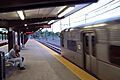
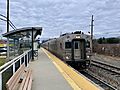
The NJ Transit Atlantic City Line train stops at the Cherry Hill station, connecting Philadelphia and Atlantic City.
The Woodcrest station of the PATCO Speedline is also in Cherry Hill. This train line provides service between Lindenwold and Philadelphia, Pennsylvania.
Some airlines from Taiwan, like China Airlines and EVA Air, offer shuttle bus services from Cherry Hill to John F. Kennedy International Airport in New York City.
Notable People
Many interesting people have lived in Cherry Hill. You can find a full list of them in the main article about notable people from Cherry Hill.
Rankings and Recognition
Cherry Hill has received several awards and recognitions:
- In 2006, Money magazine named Cherry Hill one of the 'Best Places to Live' in the United States. It was also ranked as the eighth safest place to live in the same survey.
- Philadelphia magazine also named Cherry Hill among the "Best Places to Live" in the Philadelphia area in 2006.
Images for kids
-
The Cherry Hill Public Library
-

Seal of Cherry Hill, New Jersey
-
Location of Cherry Hill in Camden County
-
Census Bureau map of Cherry Hill
-

The Cherry Hill Mall sign
-

TD Bank, N.A. headquarters
-
PATCO train at Woodcrest Station
-
NJ Transit train at Cherry Hill station

See also
 In Spanish: Cherry Hill para niños
