
Corn Islands facts for kids
Quick facts for kids
Corn Islands
|
||
|---|---|---|
|
Municipality
|
||
.png)
Map of the Corn Islands
|
||
|
||
| Motto(s):
The Eden of the Caribbean of Nicaragua
|
||
| Anthem: Corn Island song | ||

Corn Islands
Location in Nicaragua

Corn Islands
Location in Caribbean
|
||
| Country | ||
| Region | ||
| Founded by | British | |
| Seat | Brig Bay | |
| Government | ||
| • Type | Mayor-council government | |
| Area | ||
| • Total | 5.0 sq mi (12.9 km2) | |
| Elevation | 371 ft (113 m) | |
| Population
(2020)
|
||
| • Total | 7,747 | |
| Time zone | Central Standard Time | |
| Area code(s) | +505 | |
| Website | www.cornisland.gob.ni | |

The Corn Islands are two beautiful islands located about 70 kilometers (43 miles) east of Nicaragua's Caribbean coast. They form one of the 12 municipalities in Nicaragua's South Caribbean Coast Autonomous Region. The official name of this area is Corn Island, even though Nicaragua is a Spanish-speaking country.
Contents
History of the Corn Islands
The first people to live on Corn Island were the Indigenous Kukras. Later, the Indigenous Miskitos, working with English buccaneers (who were like pirates), took over the island. The island was a useful stop for ships. They could get firewood and water there, fix their boats, and use it as a base for fishing.

In the mid-1700s, Puritan settlers from Britain arrived. They brought with them enslaved people from Africa. These settlers came from Jamaica and then Belize before reaching Nicaragua's Atlantic coast. The first settlers chose to live in the southeastern part of the island. This was because Quinn Hill offered a great view of the sea. From there, they could spot pirate ships coming towards "Insurance Harbor." This harbor was a safe place for boats to anchor and unload.
"Insurance Harbor" is also important because Colonel Alexander McDonald landed there on August 27, 1841. He was a British official from Belize. Colonel McDonald gathered the enslaved workers at South West Bay. He then declared them free from slavery. This was done in the name of Queen Victoria of Great Britain.

After the English colonists settled, their culture began to mix with the local way of life. Many settlers came as adventurers looking for wealth. They stayed and had families with the enslaved people. This led to the creation of the Creole community on Corn Island. Over time, these descendants adopted English customs and traditions. This is how the unique Creole ethnic group of Corn Island developed.
Eleven years after slavery ended, on August 25, 1852, the first church and school were built. Reverend Edward Kelly from Belize founded the Ebenezer Baptist Church and School. He was the one who brought Christianity to the people of Corn Island.
From 1655 to 1894, Corn Island was part of the British Empire's protectorate. This area was known as the Mosquito Coast. Pirates often visited the islands during this time. In 1894, the government of Nicaragua took control of the area.
Later, in 1914, the islands were leased to the United States for 99 years. This was part of the Bryan-Chamorro Treaty. Under this agreement, the islands followed U.S. law, but Nicaragua still owned them. In 1940, Corn Island became a municipality (a local government area).
The United States had rights to use the islands until April 25, 1971. On that date, the agreement was officially canceled. This happened under the presidency of Anastasio Somoza Debayle. Before this, the municipality had a governor, not a mayor. Mayors used to be chosen by a community meeting. The first time all the people voted for their leaders was in the early 1900s.
Geography of the Corn Islands
The Corn Islands are made up of two main islands. The first is Great Corn Island, which is often just called Corn Island. It covers an area of 10 square kilometers (3.9 square miles). The second is Little Corn Island, which is smaller at 2.9 square kilometers (1.1 square miles). Together, they have a total area of 12.9 square kilometers (5 square miles).

The highest point on Great Corn Island is Mount Pleasant Hill, in the north. It is 113 meters (371 feet) tall. Little Corn Island's highest point is Lookout Point, in its northern part, reaching 38 meters (125 feet).
Island Climate
The Corn Islands have a tropical rainforest climate. This means it's usually hot and rainy all year. There is a slightly drier time from February to April. However, rain still falls often during this period. For the rest of the year, it rains a lot, especially from May to January. This is because of the way the coast is shaped, which catches winds carrying rain.
| Climate data for Corn Islands, Nicaragua | |||||||||||||
|---|---|---|---|---|---|---|---|---|---|---|---|---|---|
| Month | Jan | Feb | Mar | Apr | May | Jun | Jul | Aug | Sep | Oct | Nov | Dec | Year |
| Mean daily maximum °C (°F) | 27.8 (82.0) |
28.4 (83.1) |
29.0 (84.2) |
29.8 (85.6) |
29.9 (85.8) |
28.9 (84.0) |
28.1 (82.6) |
28.5 (83.3) |
29.1 (84.4) |
28.8 (83.8) |
28.4 (83.1) |
28.0 (82.4) |
28.7 (83.7) |
| Daily mean °C (°F) | 24.9 (76.8) |
25.2 (77.4) |
26.2 (79.2) |
27.0 (80.6) |
27.0 (80.6) |
26.0 (78.8) |
25.6 (78.1) |
25.6 (78.1) |
25.8 (78.4) |
25.6 (78.1) |
25.3 (77.5) |
25.2 (77.4) |
25.8 (78.4) |
| Mean daily minimum °C (°F) | 22.2 (72.0) |
22.3 (72.1) |
23.3 (73.9) |
23.7 (74.7) |
24.2 (75.6) |
23.9 (75.0) |
23.7 (74.7) |
23.6 (74.5) |
23.5 (74.3) |
23.1 (73.6) |
22.8 (73.0) |
22.6 (72.7) |
23.2 (73.8) |
| Average precipitation mm (inches) | 218 (8.6) |
114 (4.5) |
71 (2.8) |
101 (4.0) |
264 (10.4) |
581 (22.9) |
828 (32.6) |
638 (25.1) |
383 (15.1) |
418 (16.5) |
376 (14.8) |
328 (12.9) |
4,320 (170.2) |
| Average rainy days (≥ 1.0 mm) | 19 | 13 | 10 | 10 | 15 | 23 | 26 | 25 | 21 | 21 | 20 | 22 | 225 |
| Source: HKO | |||||||||||||
People of the Corn Islands
In 2020, about 7,747 people lived on the islands. Most of the islanders are Creole people. They are of African descent and speak English. Some also have mixed Indigenous heritage.
Island Neighborhoods
The municipality of Corn Island is divided into six neighborhoods, called barrios. Five of these are on Great Corn Island. Little Corn Island makes up the sixth neighborhood.
| Neighborhood | Location | Sub-divisions |
|---|---|---|
| Brig Bay | west | Passion Street, Vicente, Pomar, South West Bay, Woula Point, Broad Bay. |
| Quinn Hill | south | Bluff Point, Hill Road |
| South End | east | Long Bay, Mount Pleasant, Rama |
| Sally Peachie | northeast | Sally Peachie, Little Hill, Sand Fly Bay |
| North End | northwest | North End, Back Road |
| Little Corn Island | island 13 km northeast |
The Village, Carib Town |
Getting Around the Islands
| Tower shape | square pyramidal skeletal tower with balcony and light |
|---|
Great Corn Island has a paved road that is about 12 kilometers (7.5 miles) long. It goes all around the island. Cars, motorbikes, and bicycles are the main ways people travel. Most cars are used as taxis. A ride for an adult costs 20 Cordobas (Nicaraguan currency). There is also a bus that goes around the island clockwise, costing 10 Cordobas.

You can reach Little Corn Island by fast boats. These boats usually run three or four times a day from Great Corn Island, depending on the weather. There is also a small cargo ship from Southwest Bay on Great Corn Island. Little Corn Island has no motor vehicles. Because it's so small, everyone walks to get around.
Travel by Air
You can fly to Great Corn Island! La Costeña airline has flights from Managua or Bluefields. Planes arrive twice a day at Corn Island Airport.
Travel by Sea
You can also get to Great Corn Island by ferry or a small speedboat. These leave from the city of Bluefields every Wednesday and Saturday.
Island Economy and Tourism
For most of the 1900s, the economy of the Corn Islands was based on growing coconuts. In the 1960s and 1970s, commercial fishing became the main industry. This included lobster and shrimp fishing.

Recently, tourism has grown a lot in the region, and this has also helped the islands. The Corn Islands are now a popular place for visitors. They have many coral reefs around them, making them great for scuba diving and snorkeling. You can see amazing marine life around the islands. This includes barracudas, nurse sharks, hammerhead sharks, green sea turtles, and spotted eagle rays.
Sports on the Islands
Baseball is a very popular sport in the Corn Islands. The main place to play baseball is the Karen Tucker Baseball Stadium. Volleyball and Football are also sports that many islanders enjoy playing.
Island Food
The food on Corn Island is very diverse. Most dishes are made with seafood and local ingredients. Some typical dishes include crab soup, rondon (a stew), fried fish, and rice with shrimp.
Famous People
- Cheslor Cuthbert, a professional baseball player who played for the Chicago White Sox.
Gallery
-
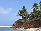
Coast of Little Corn Island
-
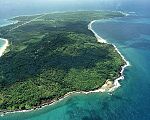
Aerial view of Corn Island
-
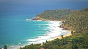
Long Bay, Corn Island


See also
 In Spanish: Corn Island para niños
