
Corrèze (river) facts for kids
Quick facts for kids Corrèze |
|
| Occitan: Corresa | |
| River | |
 The Corrèze river at Tulle
|
|
| Country | France |
|---|---|
| Region | Nouvelle-Aquitaine |
| Department | Corrèze |
| Communes | Tulle, Malemort, Brive-la-Gaillarde |
| Tributaries | |
| - left | Dadalouze, Saint-Bonnette, Roanne, Loyre |
| - right | Corrèze de Pradines, Vimbelle, Solane, Céronne, Couze |
| Cities | Brive-la-Gaillarde, Tulle |
| Source | Plateau de Millevaches |
| - location | Pérols-sur-Vézère, Massif Central, France |
| - elevation | 910 m (2,986 ft) |
| - coordinates | 45°32′52″N 2°01′01″E / 45.54778°N 2.01694°E |
| Confluence | Vézère |
| - location | Saint-Pantaléon-de-Larche / Ussac, Nouvelle-Aquitaine, France |
| - elevation | 98 m (322 ft) |
| - coordinates | 45°10′0″N 1°27′37″E / 45.16667°N 1.46028°E |
| Length | 94.6 km (59 mi) |
| Basin | 1,158 km² (447 sq mi) |
| Discharge | for Brive-la-Gaillarde |
| - average | 21 m³/s (742 cu ft/s) |
The Corrèze (Occitan: Corresa) is a river in southwestern France. It's a "tributary," which means it's a smaller river that flows into a bigger one. The Corrèze river flows into the Vézère river. The Corrèze area, called a department, is actually named after this river!
Contents
About the Corrèze River
The Corrèze river is about 94.6 kilometers (or 58.8 miles) long. Imagine a line of nearly 100,000 meters! The area of land that drains water into the Corrèze river is called its drainage basin. This basin covers a huge space of 1,158 square kilometers (about 447 square miles).
Water Flow and Discharge
The amount of water flowing in a river is called its discharge. On average, the Corrèze river carries about 21 cubic meters of water every second near the city of Brive-la-Gaillarde. That's like 21 large bathtubs of water passing by every second!
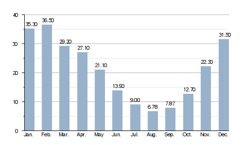
Average monthly water flow (in cubic meters per second) at Brive-la-Gaillarde (from 1918 to 2011)
The Journey of the Corrèze River
The Corrèze river starts its journey high up in the Massif Central mountains. This area is called the plateau of Millevaches. The exact source is near a small town called Pérols-sur-Vézère, in the Corrèze department. It begins at a high altitude of 910 meters (about 2,986 feet) above sea level.
Cities and Towns Along the Way
As the river flows, it passes through several interesting communes (which are like small towns or districts) in the Corrèze department. It goes through the town of Corrèze itself and then the city of Tulle.
After that, the river reaches a flatter area in the southwest of the department. Here, it flows through towns like Malemort-sur-Corrèze and the larger city of Brive-la-Gaillarde.
Where the River Ends
Finally, after its long journey, the Corrèze river joins the Vézère river. This meeting point is west of Brive-la-Gaillarde, right where the towns of Saint-Pantaléon-de-Larche and Ussac meet. At this point, the river is much lower, at an altitude of only 98 meters (about 321 feet).
The Corrèze river flows through 24 different communes, all of them located within the Corrèze department. It's pretty cool that the river's name, Corrèze, is also used for the department and for three of the communes it passes through: Les Angles-sur-Corrèze, Corrèze, and Malemort-sur-Corrèze.
Main Rivers Joining the Corrèze
Many smaller rivers, called tributaries, flow into the Corrèze river, adding to its water. Here are some of the most important ones:
|
Rivers Joining from the Left:
|
Rivers Joining from the Right:
|
Related pages
