Cottam, East Riding of Yorkshire facts for kids
Quick facts for kids Cottam |
|
|---|---|
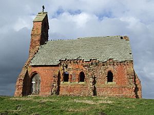
 Cottam Church of the Holy Trinity |
|
| Population | 108 (2011 census) |
| OS grid reference | SE994646 |
| • London | 175 mi (282 km) S |
| Civil parish |
|
| Unitary authority | |
| Ceremonial county | |
| Region | |
| Country | England |
| Sovereign state | United Kingdom |
| Post town | DRIFFIELD |
| Postcode district | YO25 |
| Dialling code | 01377 |
| Police | Humberside |
| Fire | Humberside |
| Ambulance | Yorkshire |
| EU Parliament | Yorkshire and the Humber |
| UK Parliament |
|
Cottam is a small place in the East Riding of Yorkshire, England. It's known as a hamlet, which is a very small village. Cottam is located in an area called the Yorkshire Wolds. It's about 16 miles (26 km) north of Beverley, a larger town, and about 4 miles (6 km) east of the village of Sledmere.
Cottam is also a civil parish. This means it's a local government area. The parish includes the hamlet of Cottam itself and another small place called Cowlam, which is about 2.5 miles (4 km) to the north-west. In 2011, the population of Cottam parish was 108 people. This was an increase from 74 people in 2001.
Contents
History of Cottam
What Does Cottam Mean?
The name Cottam comes from an old English word. It means "a place with cottages or huts." This tells us that Cottam was likely a small settlement with simple homes a long time ago.
Cottam in the Domesday Book
Cottam is mentioned in the Domesday Book. This was a huge survey of England ordered by William I in 1086. In the Domesday Book, Cottam was called 'cottun'. It was part of an area called Toreshou.
Back then, Cottam had five areas of land that could be ploughed. Before 1066, a person named Ulf of Carlton owned the land. By 1086, the land was given to the Archbishop of York, Thomas of Bayeux. He was a very important person who held land directly from the King.
An Old Village That Disappeared
Cottam used to be a bigger village a long time ago, during the Anglo-Scandinavian period (around the 9th to 11th centuries). But over time, the village became deserted. Today, the main building left is the old Church of Holy Trinity. This church was rebuilt in 1818 and again around 1890. The font (a basin for holy water) from the very first Norman church on this site is now in the church at Langtoft.
In 1823, a record showed that Cottam was part of the Langtoft parish. It was a small place with only 16 people, including a church leader and a farmer.
RAF Cottam
During the Second World War, an airfield called RAF Cottam was built nearby. It was meant for bomber planes. However, it was never actually used for flying missions. Later, the runways were used to store bombs. The buildings were taken down in 1980.
 | Shirley Ann Jackson |
 | Garett Morgan |
 | J. Ernest Wilkins Jr. |
 | Elijah McCoy |


