
Dharawal National Park facts for kids
Quick facts for kids Dharawal National ParkNew South Wales |
|
|---|---|
|
IUCN Category II (National Park)
|
|

Waterfall, Dharawal National Park
|
|

Dharawal National Park
Location in New South Wales
|
|
| Nearest town or city | Appin |
| Established | 26 March 2012 |
| Area | 65.08 km2 (25.1 sq mi) |
| Managing authorities | NSW National Parks & Wildlife Service |
| Website | Dharawal National Park |
| See also | Protected areas of New South Wales |
The Dharawal National Park is a special protected area in New South Wales, eastern Australia. It's located in the Illawarra region, about 45 kilometres (28 miles) southwest of Sydney. This national park covers about 6,508 hectares (16,082 acres) of land.
The park is found between the Illawarra Range and the Georges River. You can enter it from three main points: Darkes Forest in the east, Wedderburn in the north, and Appin in the south.
Dharawal National Park is home to many different plants and animals. It also has important cultural sites for Aboriginal people. The park is very important for conservation because it's mostly untouched by human activity. Its landscape includes deep gorges, beautiful waterfalls, high swamps, and forests. You might spot koalas, wallabies, platypuses, and many other amazing creatures here.
The main goals for the park are to protect its nature and cultural history. It also offers chances for learning, research, and some fun outdoor activities.
Contents
Who Are the Dharawal People?
The name Dharawal comes from the Dharawal community, the Aboriginal people who have lived in this area for over 15,000 years. They used to live in a large area from Botany Bay south to the Shoalhaven River.
Many ancient sites have been found within Dharawal National Park. These sites show rock art, including drawings, paintings, and stencils. The art was made using natural colours like black charcoal, white clay, or red, yellow, and orange ochre. About 236 such sites have been discovered inside the park.
How the Park Was Formed
In 1927, the O’Hares Creek area was set aside to collect water for Sydney. Later, in 1978, it was decided that this area wouldn't be needed for water supply anymore. So, the Government of New South Wales suggested making it a recreation area.
It took a long time, but in 1996, the area became a nature reserve and a state recreation area. Then, in 2001, all state recreation areas in New South Wales became state conservation areas.
The difference between a Nature Reserve and a State Conservation Area was important. In a State Conservation Area, some activities like coal mining were still allowed. But in a Nature Reserve, the rules were much stricter to protect nature.
Finally, on March 26, 2012, most of the Dharawal State Conservation Area became a full national park. This change means there are now much stronger rules against activities like coal mining. This helps protect the park's environment from deep underground to the surface.
What the Park Looks Like
Dharawal National Park is located on the southern edge of the Sydney Basin. It's part of a larger network of protected areas. These include the Royal National Park to the north and the Greater Blue Mountains Area to the west. Together, these parks form one of the biggest protected areas in New South Wales.
The park includes the O’Hares and Stokes Creeks, which are the starting points for the Georges River. There are over 200 kilometres (124 miles) of waterways and 26 swamps within the park. These waters flow towards the Nepean and Georges rivers.
The land is mostly made of Hawkesbury Sandstone, which is a type of rock. The soil is usually shallow and sandy, and it can easily erode. The park has 13 different types of plant communities, with sandstone woodland and eastern gully forest being the most common.
The weather here is mild. Temperatures range from about 6°C (43°F) in winter to 27°C (81°F) in summer. The park gets a good amount of rain each year, between 850 and 1550 millimetres (33 to 61 inches).
Plants and Animals
Dharawal National Park is a hotspot for different species. The upland swamps, for example, are incredibly rich in plant life, with over 140 plant species. These swamps have stayed almost the same for 17,000 years, making them very important for science.
The creeks in the park, like Stokes and O’Hares Creeks, are also protected. This means very little pollution is allowed in them. The park is important because it has kept its natural ecosystems and habitats healthy, unlike some surrounding areas that have been damaged.
Amazing Plants
The park's forests and woodlands have unique plant mixes. Some plant communities are rare in other Sydney conservation areas. For example, the O’Hares Creek Shale Forest and the black cypress pine are both considered endangered.
Out of 510 recorded plant species, several are listed as endangered or vulnerable. This means they are at risk of disappearing. The park is also vital for 24 uncommon species and is the southernmost home for 11 others in the region.
Wonderful Animals
The park is buzzing with animal life! So far, 128 bird species, 39 reptile species, 32 mammal species, and many more have been recorded. Sadly, 23 of these animal species are listed as threatened.
You can find platypuses, wombats, and different types of kangaroos and wallabies here. The park is especially important because it has the largest population of koalas in southern Sydney. These koalas are endangered, and their numbers are shrinking.
Other special animals include the eastern pygmy possum, giant burrowing frog, and the broad-headed snake. The broad-headed snake and red-crowned toadlet live under rocks on sandstone plateaus. This habitat is rare and well-preserved in Dharawal National Park.
The park is also critical for protecting species like the broad-headed snake, spotted-tailed quoll, and grey-headed flying fox. Many of these animals are losing their homes, so the park provides a safe haven.
The creeks are home to various freshwater fish, including the threatened Macquarie perch. You can also find long-finned eels and different types of crayfish here.
What Threatens the Park?
The park faces several challenges that could harm its natural beauty and wildlife.
Pests
About 50 types of plants in the park are not native; they are introduced. These "weeds" often grow where people have been, like along roads or at the park's edges. Some common weeds include crofton weed and pampas grass. Weeds from outside the park also threaten to spread in.
There are also introduced animals like foxes, feral dogs, cats, rabbits, and deer. These animals can be a big danger to native species. For example, foxes and feral cats hunt koalas and other small animals. Mosquito fish can also harm native fish populations.
Water Issues
Water is taken from the creeks in the park for other uses. This can reduce the amount of water flowing downstream. There are also five weirs (small dams) built in the creeks. These weirs can stop native fish from moving freely, which affects their life cycle.
Mining Concerns
Even though the park is protected, there have been concerns about coal mining nearby. Mining can cause cracks in creek beds, which can change how water flows and harm aquatic animals. Sometimes, old mining waste has been used to build trails, and this can wash into streams during rain, making the water unhealthy for plants and animals.
Fires
Wildfires are a big threat to the park's plants and animals. They can destroy habitats, especially for koalas. Fires can start accidentally from bushwalkers or on purpose by arsonists. So, managing fire risk is a very important job for the park.
How the Park is Managed
The park management works hard to protect and preserve Dharawal National Park's nature and cultural heritage. They want to keep it as natural as possible.
A big focus is on keeping the water catchments healthy. The upland swamps are also a top priority because they contain many rare species. The park management also helps protect areas just outside the park's borders.
They work to remove invasive weeds like whisky grass and African love grass. They also control the populations of introduced animals like foxes, feral dogs, cats, and deer every year. Using coal mining waste in the park has been stopped.
Fire management is also key. This includes reducing flammable material and using controlled burns to prevent big wildfires. They also fix areas where soil has eroded, especially in the swamp regions. Water quality in the creeks is constantly checked, and efforts are made to limit water pumping when water levels are low.
Images for kids
-
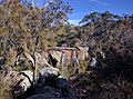
Madden's Falls in Dharawal National Park
-
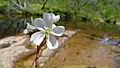
Forked Sundew (Drosera binata) in Dharawal National Park

.jpg)
