
Districts of Pakistan facts for kids

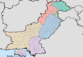
Pakistan is a country in South Asia with different parts, or "subdivisions," that help manage its land and people. Think of these like big regions or states within a country. Each subdivision is then divided into smaller areas called districts. These districts are like counties or smaller administrative zones. They help the government organize services and manage local communities more easily.
This article will help you understand how Pakistan is divided. We'll look at the main subdivisions, how many districts each has, its size (area), and how many people live there (population). Knowing about these divisions helps us understand how Pakistan works and how its different regions are organized.
Contents
Pakistan's Main Subdivisions
Pakistan has several main subdivisions, each with its own unique features. These include four provinces, a special capital territory, and other important regions.
| Sr. No. | Subdivision | Number of Districts | Area (km²) | Population (1998) | Density (people/km²) |
| 1 | Balochistan | 33 | 347,190 | 6,566,000 | 18.9 |
| 2 | Khyber Pakhtunkhwa | 35 | 74,521 | 17,744,000 | 238.1 |
| 3 | Punjab | 36 | 205,345 | 73,621,000 | 358.52 |
| 4 | Sindh | 30 | 140,914 | 30,440,000 | 216.02 |
| 5 | Islamabad Capital Territory | 1 | 906 | 805,000 | 880.8 |
| 6 | Federally Administered Tribal Areas (FATA) | 7 tribal agencies and 6 frontier regions | 27,220 | 3,176,000 | 116.7 |
| 7 | Azad Kashmir | 10 | 13,297 | 2,972,500 | 258 |
| 8 | Gilgit-Baltistan | 14 | 72,971 | 1,800,000 | 24.8 |
Islamabad Capital Territory
The Islamabad Capital Territory (ICT) is a special area that includes Islamabad, the capital city of Pakistan. It's like Washington D.C. in the USA, meaning it's not part of any province but is managed directly by the federal government. It has only one district, which is Islamabad itself.
| Capital Territory | Area (km²) | Population (1998) | Density (people/km²) |
| Islamabad | 906 | 805,235 | 889 |
Balochistan Province

Balochistan is the largest province in Pakistan by area. It's known for its dry, mountainous land and long coastline. It has 33 districts, but it's the least populated province, meaning fewer people live there compared to its large size. The capital city is Quetta.
Khyber Pakhtunkhwa Province

Khyber Pakhtunkhwa (often called KP) is a province in the northwest of Pakistan. It's known for its rugged mountains and historical passes, like the Khyber Pass. This province has 35 districts. Its capital city is Peshawar.
Punjab Province
_Districts.svg)
Punjab is the most populated province in Pakistan. It's known for its fertile lands, which are great for farming, and its rich history. Punjab has 36 districts, making it the province with the highest number of districts. The capital city is Lahore, which is a very old and culturally important city.
Sindh Province

Sindh is a province in the southeast of Pakistan, famous for the Indus River and its long coastline along the Arabian Sea. It has 30 districts. The biggest city in Pakistan, Karachi, is located in Sindh and serves as its capital. Karachi is a huge port city and a major business hub.
Federally Administered Tribal Areas (FATA)

The Federally Administered Tribal Areas (FATA) used to be a special region in Pakistan. It was made up of seven "tribal agencies" and six "frontier regions." These areas were managed directly by the federal government and had their own unique rules. In 2018, FATA was merged with the Khyber Pakhtunkhwa province, so it is no longer a separate administrative unit.
Azad Jammu and Kashmir

Azad Kashmir (officially called Azad Jammu and Kashmir) is a self-governing territory in Pakistan. It's known for its beautiful mountains and green valleys. It has 10 districts. The capital city is Muzaffarabad.
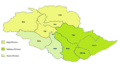
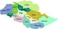
Gilgit-Baltistan

Gilgit-Baltistan is a northern territory of Pakistan, famous for its very high mountains, including some of the world's tallest peaks. It has 14 districts. The capital city is Gilgit. This region is a popular spot for adventurers and mountain climbers.

Images for kids
-
Districts of Pakistan
-
Gilgit Baltistan Administrative divisions and districts
-
Gilgit Baltistan's map with districts


