
Dry Fork (Cheat River tributary) facts for kids
Quick facts for kids Dry Fork |
|
|---|---|

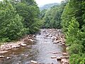
The Dry Fork near Harman
|
|

Map of the Monongahela River basin, with Dry Fork highlighted.
|
|
| Country | United States |
| State | West Virginia |
| Counties | Tucker, Randolph |
| Cities | Hendricks, Harman |
| Physical characteristics | |
| Main source | Col between Harper and Yokum knobs, Randolph County 3,740 ft (1,140 m) 38°44′01″N 79°38′52″W / 38.73361°N 79.64778°W |
| River mouth | Confluence with Blackwater River Hendricks, Tucker County 1,700 ft (520 m) 39°04′20″N 79°37′45″W / 39.07222°N 79.62917°W |
| Basin features | |
| Tributaries |
|
The Dry Fork is a river in eastern West Virginia, USA. It's about 39 miles (63 km) long. This river is a "tributary," which means it's a smaller river that flows into a bigger one. The Dry Fork joins the Black Fork, which then flows into the Cheat River.
Eventually, its water travels through the Monongahela and Ohio rivers. Finally, it reaches the mighty Mississippi River! So, the Dry Fork is part of the huge watershed of the Mississippi.
Most of the Dry Fork flows through the beautiful Monongahela National Forest. It passes through quiet, rural areas and thick forests. People used to think of it as one of the five main "Forks of Cheat."
Contents
What's in a Name?
The Dry Fork river has a cool secret! Sometimes, parts of the river flow underground. This leaves the streambed on the surface looking dry. That's how it got its name, "Dry Fork."
Historically, some people also called it "Dry Run." If you want to learn more about rivers flowing underground, check out the Sinks of Gandy.
Where Does the Dry Fork Flow?
River's Journey
The Dry Fork starts its journey in eastern Randolph County. It begins between two mountains called Rich Mountain and Little Middle Mountain.
At first, the river flows north-northeast. It passes by small towns like Whitmer, Job, and Harman.
Path Through Counties
After a while, the Dry Fork enters Tucker County near the town of Dryfork. Here, it changes direction and flows northwest.
Its journey ends in the town of Hendricks. This is where the Dry Fork meets the Blackwater River. Together, they form the Black Fork.
Rivers Joining In
Many smaller streams and rivers join the Dry Fork along its path. These are called "tributaries."
- Gandy Creek: This creek joins the Dry Fork near the town of Gandy. Gandy Creek is famous because it flows through a well-known cave called the "Sinks of Gandy."
- Laurel Fork: This tributary joins the Dry Fork in Randolph County.
- Glady Fork: You'll find this one joining the Dry Fork in Tucker County. Both the Laurel Fork and Glady Fork are important rivers that feed into the Cheat River system.
- Red Creek: This creek flows into the Dry Fork at the town of Dryfork. Red Creek drains a large part of the Dolly Sods Wilderness area, which is a beautiful natural space.
Images for kids
-
The Dry Fork near Harman, West Virginia
-
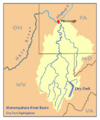
Map of the Monongahela River basin, with Dry Fork highlighted.
See also
- List of West Virginia rivers
