
Eagle Peak (Wyoming) facts for kids
Quick facts for kids Eagle Peak |
|
|---|---|

Eagle Peak
|
|
| Highest point | |
| Elevation | 11,372 ft (3,466 m) NAVD 88 |
| Prominence | 1,847 ft (563 m) |
| Geography | |

Eagle Peak
Location in Wyoming

Eagle Peak
Location in the United States
|
|
| Location | Park County, Wyoming, U.S. |
| Parent range | Absaroka Range |
| Topo map | USGS Eagle Peak |
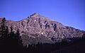
Eagle Peak is a tall mountain in the Absaroka Range in Wyoming, USA. It stands at 11,372 feet (3,466 m) high. This makes it the highest point in Yellowstone National Park! You can find it about 6 miles (9.7 km) east of the southeast part of Yellowstone Lake.
Contents
Why is it called Eagle Peak?
There are two cool stories about how Eagle Peak got its name.
One story says a geologist named Arnold Hague named it in 1885. He thought the mountain looked like an eagle with its wings spread out.
Another story says it was named earlier, in 1878. A person named Jack Newell is said to have killed a golden eagle on the mountain that year.
A Look Back: Eagle Peak's History
For a long time, many park officials and scientists thought a different mountain, Electric Peak, was the highest in Yellowstone. This was true until the 1930s.
Eagle Peak is ranked as the 218th highest peak in Wyoming. It is also the 2252nd highest peak in the entire United States.
During the big Yellowstone fires of 1988, the southern parts of Eagle Peak were affected. The Mink Fire reached these slopes.
How Eagle Peak Was Formed: Geology
Eagle Peak is part of the Absaroka Range. It is made of rocks that formed during the Eocene period. These rocks are called volcaniclastic rocks. This means they are made from pieces of volcanoes.
During the last ice age, a thick ice cap covered this area. It was more than 1,600 feet (490 m) deep! You can still find Glacial deposits in some places on the mountain today. These are rocks and dirt left behind by the moving ice.
Exploring Eagle Peak's Geography
Eagle Peak is located in the Absaroka Range. It sits right on the edge of Yellowstone National Park. The other side of the boundary is the Shoshone National Forest in northwestern Wyoming.
The mountain rises about 6 mi (9.7 km) east of the southeast arm of Yellowstone Lake. It is also one of the highest points in the Washakie Wilderness area. This wilderness is part of the Shoshone National Forest.
Eagle Peak is similar in height to other mountains nearby. There is a ridge that slowly gets higher as it goes southeast. This ridge ends in several peaks. Mount Schurz, which is right to the northwest, is a bit shorter. Pinnacle Mountain, to the immediate southeast, is taller. However, Pinnacle Mountain is outside the park boundary.
Several creeks flow through Eagle Peak and the areas around it. These creeks carry cold meltwater from snow and ice. The Gardner River flows to the east of the mountain's top. Some of the water comes from two large snowfields. These snowfields are found in the shadows on the north side of the mountain.
The mountains to the east drain into the Yellowstone River. This water then flows into the Bighorn River. But the southern slopes of Eagle Peak drain into Yellowstone Lake through Mountain Creek.
Eagle Peak is a very important feature in the Eagle Peak Quadrangle. This is a special area used by the USGS for mapping. Other nearby peaks include Mount Humphreys, Table Mountain, Mount Schurz, Pinnacle Mountain, Turret Mountain, and Colter Peak.
How to Reach Eagle Peak
This mountain is quite hard to get to. It is about a 15-mile (24 km) hike from any of the main park roads.
You can also climb the peak from outside the park. One way is to hike up the Fish Hawk Creek valley. This path is about 25 kilometres (16 mi) long, one way.
Another way to climb it is from inside Yellowstone Park. You can sail to the very southeastern tip of Yellowstone Lake. Then, you hike down the Yellowstone River valley. From there, you turn east to start your climb up the mountain.
Wildlife Around Eagle Peak

The animals and plants around Eagle Peak live in the alpine tundra zone. This is a very cold, high-altitude area. These species might be at risk from global climate change. As the climate warms, animals and plants might try to move higher up the mountains. This could mean some species are lost from the park forever.
To the south of Eagle Peak, on the park boundary, are Eagle Pass and the Thorofare Plateau. This area is home to many animals. You can find elk, moose, deer, bears, and bighorn sheep here. It is also an important path for elk migrating between north and south.
The plants in this area include different types of sedges and rushes. You can also find tufted hairgrass in the open alpine meadows.
Images for kids
-
Eagle Peak
