
East Boston facts for kids
Quick facts for kids
East Boston
|
||
|---|---|---|

An airplane approaching Logan International Airport in 1973
|
||
|
||
| Nicknames:
Eastie
|
||

Neighborhood map of East Boston, Massachusetts
|
||

East Boston
Location in Greater Boston area

East Boston
Location in Massachusetts

East Boston
Location in the United States
|
||
| Country | United States | |
| State | Massachusetts | |
| County | Suffolk | |
| Neighborhood of | Boston | |
| Annexed by Boston | 1637 | |
| Area | ||
| • Land | 4.7 sq mi (12 km2) | |
| Population
(2010)
|
40,508 | |
| • Density | 8,618/sq mi (3,327/km2) | |
| Time zone | UTC-5 (Eastern) | |
| Zip Code |
02128, 02228
|
|
| Area code(s) | 617 / 857 | |

East Boston, often called Eastie, is a lively neighborhood in Boston, Massachusetts. It became part of Boston in 1637. This area is special because it was created by connecting five small islands with land fill in the 1940s.
East Boston is famous for being a home for many immigrants. Over the years, people from Ireland, Russian Jews, Italians, and more recently, Latin American immigrants have settled here. In fact, over half of the people living in East Boston today are from Latin American countries. Logan International Airport, a major airport, is also located in East Boston.
Contents
How Did East Boston Begin?
The land that is now East Boston was once five separate islands. These islands were Noddle's, Hog's, Governor's, Bird, and Apple. They were located across the harbor from the main city of Boston.
Noddle's Island was the largest. English colonists used it for farming and timber in the 1700s.
Early Plans for the City
.jpg)
In 1801, a man named William H. Sumner owned a lot of land on Noddle's Island. He thought it would be a great idea to build a road connecting the island to Boston. This would help Boston grow, as it was mostly surrounded by water.
His first plan for a direct road was not chosen. So, Sumner looked for other ways to make Noddle's Island more valuable.
Sumner and the East Boston Company
By 1833, William H. Sumner and his partners, Steven White and Francis J. Oliver, bought half of Noddle's Island. They started the East Boston Company. Their goal was to own and develop the land, calling it East Boston.
To prepare for new people moving in, they planned the streets in a grid pattern. This made East Boston the first planned neighborhood in Boston. Jeffries Point, facing Boston, was the first part of East Boston to be settled.
A bridge to Chelsea was built, and new roads and houses appeared. The East Boston Lumber Company helped with this growth. The Boston Sugar Refinery, which made white granulated sugar, was also one of the first factories here.
Famous Shipyards and Donald McKay

By 1835, ten wharves (docks) were built. This helped East Boston grow quickly. Shipbuilding became the most famous industry and the main part of its economy. In 1836, East Boston officially became part of Boston.
In 1845, Donald McKay opened his own shipyard. He built some of the fastest sailing ships ever, called clipper ships. His ships included the Flying Cloud (1851) and the Sovereign of the Seas (1852). The Sovereign of the Seas once sailed at an amazing speed of 22 knots!
Other important shipbuilders in East Boston during this time were Paul Curtis and Samuel Hall.
Connecting to the Mainland

In the 1830s, getting to East Boston was a big problem. The East Boston Company knew the neighborhood needed better transportation. At first, they used a small paddle steamer to carry people from Boston to East Boston.
They even tried a new type of suspension railway in 1834. This was one of the first suspended railroads ever built! The train cars hung from a track above. It only ran for nine days because not enough people used it.
Later, the company worked to bring the Eastern Railroad to East Boston. Ferry services also started, carrying people and goods between Boston and East Boston.
In 1904, the ferry service was replaced by a streetcar tunnel. This tunnel became part of the MBTA Blue Line. It was the first underwater tunnel in North America!
Boston's "Ellis Island"

Since the mid-1800s, East Boston has been a welcoming place for immigrants. First came people from Ireland and Canada. Then, Russian Jews and Italians arrived. More recently, people from Southeast Asia and Central and South America have made East Boston their home.
The Orient Heights area was where the first Italians settled in Massachusetts in the 1860s and 1870s. Today, East Boston still has a strong Italian community. The Madonna Shrine, a religious building, sits on top of the Heights.
From 1920 to 1954, the East Boston Immigration Station was the main place for immigrants arriving in Boston. Unlike Ellis Island in New York, most immigrants were processed right at the ship docks. Only those with paperwork issues or needing more interviews went to the station.
The steps leading from the station into East Boston were called the 'Golden Stairs'. This name showed that they led to "golden opportunity" in America for many Europeans.

In 1837, East Boston had only about a thousand people. By 1925, its population grew to over 64,000! This huge increase was mostly due to immigrants from Southern Italy. Today, over 40,000 people live in East Boston.
The Kennedy Family Connection
When my great grandfather left here to become a cooper in East Boston, he carried nothing with him except two things: a strong religious faith and a strong desire for liberty. I am glad to say that all of his great grandchildren have valued that inheritance.
The famous Kennedy Family has roots in East Boston. P. J. Kennedy, the great-grandfather of President John F. Kennedy, lived on Meridian Street. His success allowed him to buy homes for his son, Joseph, and his daughters in Jeffries Point.
In 1954, John F. Kennedy himself visited East Boston during his campaign for the United States Senate. He walked through the streets, waving to crowds, trying to get votes from the neighborhood. His family's connection to East Boston was often mentioned by his brother, Senator Ted Kennedy.
What to See in East Boston
Maps of East Boston
|
Neighborhood map
|

Open space map
|
Parks and Green Spaces
East Boston has many beautiful parks and green areas to enjoy:
- Belle Isle Marsh Reservation: This is the largest remaining salt marsh in Boston. It's a special place for many different plants and animals.
- Constitution Beach: A public beach in the Orient Heights part of East Boston, great for swimming and relaxing.
- Golden Stairs Terrace Park: This historic site is where the "Golden Stairs" once led immigrants into East Boston. It's now a small public park.
- Piers Park: Built on an old pier, this park has walking paths, shade areas, and the Piers Park Sailing Center. It offers amazing views of the Boston skyline.
.jpg)
Community Gardens
Many community gardens help residents grow their own food and connect with nature:
- Bremen Street Community Garden: Located in Bremen Street Park, this garden is managed by garden coordinators.
- Eagle Hill Community Garden: The Trustees of Reservations helps maintain this garden with local residents.
- EBNHC Wellness Garden: The East Boston Neighborhood Health Center runs this garden to help people live healthier lives.
- Joe Ciampa Garden: Also maintained by The Trustees of Reservations and residents.
- "Nuestro Jardín" ("Our Garden"): This garden, across from the Umana School, is now cared for by a youth program and Eastie Farm, a group working on food and climate issues.

Historic Places and Businesses
East Boston has several places listed on the National Register of Historic Places, showing its rich past.
- Santarpio's Pizza: This is one of the original pizzerias that served Italian Americans who moved to East Boston. It's a local favorite!

Historic Neighborhoods
- Central Square
- Day Square
- Eagle Hill
- Maverick Square
- Orient Heights
Important Historic Sites
Here are some of the places in East Boston listed on the National Register of Historic Places:
- Baker Congregational Church
- Barnes School
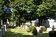
- Bennington Street Burying Ground
- Eagle Hill Historic District
- Donald McKay House
- United States lightship Nantucket (LV-112)
- Temple Ohabei Shalom Cemetery
- Trinity Neighborhood House
-
Barnes School
-
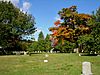
Bennington Street Burying Ground
-
Eagle Hill Historic District
-
Temple Ohabei Shalom Cemetery
-

Trinity Neighborhood House
-

Baker Congregational Church


_2.jpg)


Sports and Recreation
- Suffolk Downs: This famous horse racing track closed in 2017.
- East Boston Memorial Stadium: Since 2015, Suffolk University uses this stadium for their sports teams. It's also used by the community and East Boston High School for events like graduation.
East Boston Celebrations
East Boston has two fun annual celebrations in the summer:
- Eastie Week: This two-week event in July offers free and affordable activities for families.
- Eastie Pride Day: A long-standing celebration at Piers Park, it's free and open to everyone. It features food, music, games for kids, and community information.
Getting Around East Boston

Transportation has always been important to East Boston. Famous clipper ships were built here. In 1904, a subway tunnel opened, connecting the neighborhood to Boston. This was the first undersea tunnel of its kind in the United States!
Later, the Sumner Tunnel (1934) and Callahan Tunnel (1961) were built for cars. These tunnels directly connect East Boston to downtown Boston. The Ted Williams Tunnel (1995) also links East Boston to Interstate 90.
Logan International Airport
Logan International Airport, a very busy airport, is mostly in East Boston. The airport has grown a lot over the years. Some expansions, like in the 1960s and 70s, caused homes to be moved. To help with this, the airport has created "airport edge buffers" with parks and green spaces for residents.
It's easy to get to downtown Boston from East Boston using the MBTA Blue Line subway. The Blue Line has several stops in East Boston. Free shuttle buses also connect the Airport MBTA station to all Logan Airport terminals. The East Boston Greenway, a path along an old rail line, also connects to the Airport station.
Famous People From East Boston
Many notable people have come from East Boston, including:
- John L. Bates: A former Governor of Massachusetts.
- Benjamin A. Botkin: A scholar who studied folklore.
- Thomas J. Buckley: A former Massachusetts Auditor.
- John J. Douglass: A member of the United States House of Representatives.
- Frank Greer: An Olympic gold medalist in rowing.
- Helen Johns: An Olympic gold medalist in swimming.
- P.J. Kennedy: A Massachusetts politician and the grandfather of U.S. President John F. Kennedy.
- Augie Lio: A former American football player.
- Frederick Mansfield: A former Mayor of Boston.
- William Matthew Prior: A well-known painter.
- Gene Sharp: A scholar.
- Robert Travaglini: A former President of the Massachusetts Senate.
- Jermaine Wiggins: A former NFL player and Super Bowl champion.
