East Branch Briar Creek facts for kids
Quick facts for kids East Branch Briar Creek |
|
|---|---|

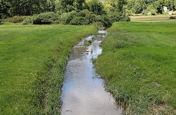
East Branch Briar Creek in late summer
|
|
| Physical characteristics | |
| Main source | lake in Briar Creek Township, Columbia County, Pennsylvania 1,000 ft (300 m) |
| River mouth | Briar Creek in Briar Creek, Pennsylvania 499 ft (152 m) |
| Length | 9.6 mi (15.4 km) |
| Basin features | |
| Basin size | 15.10 sq mi (39.1 km2) |
| Tributaries |
|
East Branch Briar Creek is a stream in Columbia County, Pennsylvania. It flows into a larger stream called Briar Creek. The creek is about 9.6 miles (15.4 km) long.
It flows through towns like Briar Creek Township, Berwick, and Briar Creek. The land that drains into the creek, called its watershed, covers about 15.10 square miles (39.1 km2). A lake called Briar Creek Lake is also part of the creek.
The water's pH (how acidic or basic it is) is usually around 6.9 near its start. Near Briar Creek Lake, it's about 7.5. The creek's temperature can change a lot, from near freezing to quite warm. The area around the creek has different rocks like shale, limestone, and sandstone. East Branch Briar Creek is known as a coldwater fishery, which means it's a good place for fish that like cold water.
Contents
Where Does East Branch Briar Creek Flow?
East Branch Briar Creek starts in a lake in Briar Creek Township. This lake is just south of Lee Mountain. The creek first flows west for a few miles.
Then, it turns southwest for more than a mile. After that, it turns south-southeast and flows past the community of Evansville. South of Evansville, the creek turns east and flows through Briar Creek Lake.
Further downstream, the creek makes a wide turn to the west. It flows along the edge of Berwick. After a short distance, it enters the community of Briar Creek. Soon after, the creek joins with Briar Creek. East Branch Briar Creek joins Briar Creek about 1.02 miles (1.64 km) before Briar Creek reaches its own end.
Smaller Streams Joining the Creek
East Branch Briar Creek has smaller streams, called tributaries, that flow into it. These include Kashinka Hollow and Glen Brook.
Kashinka Hollow joins East Branch Briar Creek about 3.58 miles (5.76 km) upstream from its mouth. The land that drains into Kashinka Hollow covers about 2.08 square miles (5.4 km2). Glen Brook joins the creek about 2.24 miles (3.60 km) upstream from its mouth. Its watershed covers about 4.96 square miles (12.8 km2).
Water Conditions in the Creek
The amount of water flowing in East Branch Briar Creek changes. In its upper parts, the flow is usually around 1.385 cubic feet per second. Near Briar Creek Lake, the flow is often around 4.645 cubic feet per second.
The water temperature also varies. Near the start of the creek, the temperature is usually around 49.73°F (9.85°C). Closer to Briar Creek Lake, the average temperature is about 50.18°F (10.10°C).
The pH of the water is important for living things. Near the creek's start, the pH is usually 6.92. Near Briar Creek Lake, it's about 7.565. The water also has a good amount of alkalinity, which helps keep the pH stable. The amount of total dissolved solids (like minerals) in the water is generally low.
Sometimes, parts of the creek have problems. Some areas are considered "non-attaining," meaning the water quality isn't as good as it should be. This can be due to water temperatures that are too high or low levels of dissolved oxygen. East Branch Briar Creek has also shown higher levels of lead and nitrates.
Land and Rocks Around the Creek
The elevation of East Branch Briar Creek changes along its path. Near where it joins Briar Creek, it is about 499 feet (152 m) above sea level. Where the creek begins, its elevation is a bit over 1,000 feet (300 m).
The types of rocks around the creek vary. The southern parts of the watershed have calcareous shale and limestone. The middle part has siltstone and shale. The northern parts have mudstone and sandstone.
The soil near Briar Creek Lake is a type called Holly Series, which is a silt loam. Closer to the creek's source, the soil is called Albrights Series, which is a gravelly silt loam. There are also large amounts of stream alluvium and colluvium along the creek, which are materials like sand and gravel deposited by water or gravity.
The Creek's Watershed
The watershed of East Branch Briar Creek covers an area of about 15.10 square miles (39.1 km2). Most of this area is in Briar Creek Township. A small part of the watershed is in Berwick. The eastern part of the watershed extends into Salem Township, Luzerne County.
History of the Creek Area
East Branch Briar Creek experienced a flood in 1955. This flood caused about $75,000 in damage to the communities of Berwick and Foundryville. Because of this and other floods, plans were made in 1967 to build Briar Creek Lake. The lake helps control flooding.
There are also old quarries on the northern side of a ridge south of the creek. One of these quarries was used to get stone. This stone was then used to make agricultural lime, which helps farmers improve their soil.
Animals and Plants in the Creek
East Branch Briar Creek is a designated coldwater fishery. This means it's a good place for fish that prefer cold water. Wild trout naturally reproduce in the creek upstream of Briar Creek Lake. This is a sign of a healthy coldwater environment.
There are also forested areas along the banks of East Branch Briar Creek. These wooded areas are very important for the ecology of the entire Briar Creek watershed. They are considered some of the most important natural features in Briar Creek Township. These forests help keep the water clean and provide homes for wildlife.
 | Mary Eliza Mahoney |
 | Susie King Taylor |
 | Ida Gray |
 | Eliza Ann Grier |


