
Briar Creek (Susquehanna River tributary) facts for kids
Quick facts for kids Briar Creek |
|
|---|---|

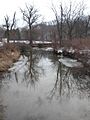
Briar Creek in Briar Creek Township
|
|
| Lua error in Module:Location_map at line 420: attempt to index field 'wikibase' (a nil value). | |
| Country | United States |
| County | Columbia County, Pennsylvania |
| Physical characteristics | |
| Main source | Knob Mountain in Briar Creek Township |
| River mouth | Susquehanna River in Briar Creek |
| Length | 7.77 mi (12.50 km) |
| Basin features | |
| Basin size | 33.0 sq mi (85 km2) |
| Tributaries |
|
Briar Creek is a cool stream located in Columbia County, Pennsylvania, in the United States. It flows for about 7.77 miles (12.50 km) before joining the big Susquehanna River. The area of land that drains into Briar Creek, called its watershed, is about 33.0 square miles (85 km2).
This creek flows through places like Briar Creek Township and the town of Briar Creek. Long ago, Native American tribes like the Lenni Lenape and the Shawanese lived near the creek. European settlers started arriving in the 1770s.
Briar Creek has two important branches: the West Branch Briar Creek and the East Branch Briar Creek. The amount of water flowing in the creek changes, but it's usually between 0.06 and 50 cubic feet per second. The water temperature can range from 32 °F (0 °C) to 80.96 °F (27.20 °C). The rocks around the creek are mostly sandstone, siltstone, mudstone, limestone, and shale.
You can find Pennsylvania State Game Lands in the area around the creek. There's also a lake called the Briar Creek Reservoir, which is a great spot for fishing. The most common fish found there is the yellow perch.
Contents
Where Does Briar Creek Flow?
Briar Creek starts in western Briar Creek Township, where three mountains meet: Knob Mountain, Huntington Mountain, and Lee Mountain.
The Creek's Journey
At first, the creek flows east for a short distance. Then, it turns south and goes through a narrow opening in Lee Mountain, where it drops quite steeply. After leaving the mountain, the creek's path becomes flatter as it flows through a valley. It goes under Pennsylvania Route 93 and then leaves the valley. Soon after, it meets its first main branch, the West Branch Briar Creek, and turns southeast.
After flowing a bit further, Briar Creek enters the town of Briar Creek. Here, it meets its second main branch, the East Branch Briar Creek. Finally, the stream turns southwest and flows into the Susquehanna River near French Island.
What Are Briar Creek's Branches?

Briar Creek has two named branches: East Branch Briar Creek and West Branch Briar Creek.
- The East Branch Briar Creek joins the main creek about 1.02 miles (1.64 km) before it reaches the Susquehanna River. The land area that drains into the East Branch is about 15.10 square miles (39.1 km2).
- The West Branch Briar Creek joins Briar Creek about 2.74 miles (4.41 km) before its mouth. Its drainage area is about 12.10 square miles (31.3 km2).
How Does the Water Flow?
The amount of water flowing in Briar Creek, called its discharge, changes depending on the location and time.
- Near its start, the water flow ranges from 0.06 to 39.1 cubic feet per second (cfs).
- Closer to where the West Branch joins, the flow is between 0.63 and 22.1 cfs.
- Near the mouth of the creek, the flow is usually between 4.14 and 50 cfs. The average flow here is about 18.5 cfs.
Water Temperature and pH
The water temperature of Briar Creek also varies.
- Near its source, the temperature is usually between 35.96 °F (2.20 °C) and 64.94 °F (18.30 °C).
- Near its mouth, the temperature can range from 32.18 °F (0.10 °C) to 80.96 °F (27.20 °C).
The pH level tells us how acidic or alkaline the water is.
- Near the mouth of Briar Creek, the pH is usually between 7.16 and 8.21, which means it's slightly alkaline (not acidic).
- Near the creek's source, the pH is a bit lower, ranging from 5.52 to 7.47.
What is the Land Like Around Briar Creek?
The area around Briar Creek is part of the ridge and valley region, which means it has many hills and valleys. The top of Lee Mountain acts like a natural border, separating the Briar Creek watershed from other areas.
Rocks and Soil
The types of rocks under the ground, called bedrock, change across the watershed:
- In the very northern parts, the bedrock is mostly sandstone.
- Further south, you'll find mudstone and siltstone.
- In the southern part, the bedrock is mainly shale and some limestone.
There are also different types of soil. For example, the Holly Series soil is an acidic silt loam, found in several spots along the creek and its branches. Other soils include the Buchanan Series (stony loam) and the Albrights Series (silt loam with gravel).
Briar Creek itself is fairly wide, between 25 feet (7.6 m) and 30 feet (9.1 m). Its West Branch is a bit narrower, about 15 feet (4.6 m) wide.
The Briar Creek Watershed Community

The Briar Creek watershed covers about 33.0 square miles (85 km2) and is located in Columbia County and Luzerne County. Several towns and townships are partly or fully within this area, including Briar Creek, Briar Creek Township, and Berwick.
The Pennsylvania Department of Environmental Protection has given the Briar Creek watershed a "B" rating. This means that people living in the area are working hard to improve and protect the natural resources there.
Land Use in the Watershed
- About 41% of the watershed is covered by forests. Much of this is on Knob Mountain or part of the Pennsylvania State Game Lands Number 55.
- About 34% of the land is used for farming.
- About 6% is urban land, meaning it has towns and buildings.
- The remaining 19% is non-agricultural grassland.
There are approximately 44.23 miles (71.18 km) of streams within the Briar Creek watershed. The watershed is also divided into seven smaller areas, called sub-watersheds.
Briar Creek Reservoir
A 53-acre lake, the Briar Creek Reservoir, is located on a branch of Briar Creek. This lake is manmade and was built in the early 1970s to help control floods. Today, it's also a popular spot for fishing and boating.
A Look Back at Briar Creek's History
Long ago, Native Americans called Briar Creek "Kawanishoning," which meant "sweet briar" in the Lenni Lenape language. During the American Revolutionary War, soldiers and explorers also used this name. By the 1770s, maps started showing it as "Bryar Creek," and later the spelling changed to "Brier Creek" and then "Briar Creek."
Early Settlers and Industries
Until about 1770, the Lenni Lenape and Shawanese tribes lived along the creek, building villages. In the 1770s, European settlers, like the White family from New Jersey, began to arrive. The land around Briar Creek was very fertile, making it one of the first places in Columbia County to be settled.
In the early 1800s, many mills were built on the creek's branches. Other businesses also started up, such as sawmills, woolen mills, and tanneries. Later in the 1800s, railroads came to the area, and more industries like fisheries began to appear.
Dams and Conservation
By 1911, two dams were built on Glen Brook, a smaller stream that flows into Briar Creek. These dams helped store water. A third, even larger dam was being built around that time.
Today, the Briar Creek Watershed Association works to protect the creek and its surrounding land. This group was formed in 2006.
Animals and Plants of Briar Creek
The Pennsylvania Department of Conservation and Natural Resources considers the Briar Creek watershed an "important place for nature."
Wildlife
More than 90 different kinds of birds make their homes and raise their young in the Briar Creek watershed. These include various types of ducks, flycatchers, herons, and swallows. You might even spot Bald eagles and sandhill cranes, especially around the Briar Creek Reservoir.
Mammals living here include minks, muskrats, and even the endangered Indiana bat. The creek is also home to many fish, damselflies, mayflies, and other small water creatures. In 2006, the Pennsylvania Fish and Boat Commission found 28 different types of fish in the watershed.
Fish in the Reservoir
In 2010, a survey of the Briar Creek Reservoir found many fish species. The most common were yellow perch, brown bullhead, golden shiner, white crappie, hatchery trout, and bluegill. The largest fish found were common carp, some as long as 25 inches (64 cm)! Small fish like minnows also live in the West Branch Briar Creek.
Fun Things to Do at Briar Creek

The Briar Creek Reservoir is a popular spot for outdoor activities. It's owned by the Pennsylvania Fish and Boat Commission and Columbia County. Even though it was first built to control floods, people now enjoy fishing, having picnics, and even holding weddings there.
The area also has Pennsylvania State Game Lands, which are great for exploring nature. The waters of Briar Creek are known as "approved trout waters," meaning the stream is regularly stocked with trout for fishing.
Images for kids
-
Briar Creek in Briar Creek Township
-
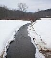
East Branch Briar Creek, a major branch of Briar Creek
-
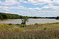
Briar Creek Reservoir in August
-
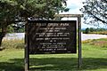
Sign for the Briar Creek Lake Park
