
East Prussia facts for kids
Quick facts for kids East Prussia
Ostpreußen (German)
|
|||||||||||||||||||
|---|---|---|---|---|---|---|---|---|---|---|---|---|---|---|---|---|---|---|---|
| Province of Prussia | |||||||||||||||||||
| 1772–1829 1878–1945 |
|||||||||||||||||||
 Flag
 Coat of arms
|
|||||||||||||||||||
 East Prussia (red), within the Kingdom of Prussia, within the German Empire, as of 1878 |
|||||||||||||||||||
 East Prussia after the First World War |
|||||||||||||||||||
| Anthem | |||||||||||||||||||
| Ostpreußenlied "Song of East Prussia" (1930—1945) |
|||||||||||||||||||
| Capital | Königsberg | ||||||||||||||||||
| Demonym | East Prussian | ||||||||||||||||||
| Area | |||||||||||||||||||
|
• 1905
|
36,993 km2 (14,283 sq mi) | ||||||||||||||||||
| Population | |||||||||||||||||||
|
• 1905
|
2,030,174 | ||||||||||||||||||
| History | |||||||||||||||||||
|
• Established
|
31 January 1772 | ||||||||||||||||||
|
• Province of Prussia
|
3 December 1829 | ||||||||||||||||||
|
• Province restored
|
1 April 1878 | ||||||||||||||||||
| 1 August 1945 | |||||||||||||||||||
| Political subdivisions | Gumbinnen Königsberg Allenstein (from 1905) West Prussia (1922–1939) Zichenau (from 1939) |
||||||||||||||||||
|
|||||||||||||||||||
| Today part of |
|
||||||||||||||||||
East Prussia was a very important region in Prussia and later Germany. It existed as a province from 1772 to 1829 and again from 1878 until 1945. Its capital city was Königsberg, which is now called Kaliningrad. East Prussia was located along the southeastern Baltic Coast.
The area was originally home to the Old Prussians, a Baltic people. In the 13th century, Teutonic Knights conquered the region. Over time, many Germans settled there. Polish and Lithuanian people also lived there. The original Old Prussian language disappeared by the 1700s.
East Prussia was once a part of the Kingdom of Poland. In 1701, it became part of the Kingdom of Prussia. After World War I, parts of East Prussia were given to Poland and Lithuania. The main part became an exclave, meaning it was separated from the rest of Germany. After World War II in 1945, East Prussia was divided between the Soviet Union and Poland. Most German residents left or were moved out.
Contents
Geography of East Prussia

East Prussia had gentle plains and small hills. The northern parts were flatter, while the south had more hills. The climate was mostly continental, with cold winters and warm summers.
The province bordered the Baltic Sea in the northwest. Long sand spits, like the Vistula Spit and Curonian Spit, separated the sea from large lagoons. Many rivers flowed into these lagoons. The Pregolya and Neman rivers were among the most important.
In the northeast, the Šešupė river formed a border with the Russian Empire. The Klaipėda Region was a part of the province north of the Neman river. This area had many bogs, which are wet, marshy lands.
Further south, the land became hillier with more lakes. The Romincka Forest was a famous hunting ground. The Masurian Lake District was known for its many beautiful lakes. The largest lake was Śniardwy. The highest point in East Prussia was Dylewska Góra, at 312 meters above sea level.
Early History

In the 13th century, the Teutonic Knights took control of the region. They created a state there. Over time, German names replaced many local Old Prussian and Polish place names. The Knights often fought with the Kingdom of Poland. A big battle, the Battle of Grunwald, happened in 1410, where Poland and Lithuania defeated the Knights.
In 1466, after another war, the region became a part of the Kingdom of Poland. Some parts were directly controlled by Poland, and others were like a special territory. In 1525, the leader of the Teutonic Knights, Albert, Duke of Prussia, became a Lutheran and created the Duchy of Prussia. This duchy was a vassal state, meaning it was still under the Polish king.
Later, in 1618, the Duchy of Prussia became connected to Brandenburg, forming Brandenburg-Prussia. In 1660, the ruler of Brandenburg-Prussia gained full control over the Duchy of Prussia, no longer being a vassal of Poland. This was a big change for the region.
In 1701, the ruler of Brandenburg-Prussia crowned himself "King in Prussia." This new kingdom became known as the Kingdom of Prussia. The old Duchy of Prussia then became known as "East Prussia."
A terrible plague and famine hit East Prussia between 1709 and 1711. About one-third of the population died. This included the last people who spoke the Old Prussian language. Later, thousands of Protestants from Salzburg, who were forced to leave their homes, settled in East Prussia.
East Prussia as a Province

In 1772, the Prussian king Frederick the Great took over more land from Poland. This connected East Prussia to the rest of his kingdom. On January 31, 1773, the new province of East Prussia was officially created.
Napoleonic Wars and Reforms

In 1806, Napoleon's army defeated Prussia. The Prussian king and queen had to flee to Memel (now Klaipėda). French troops followed them, leading to the Battle of Eylau in 1807. After more fighting, Prussia signed the Treaties of Tilsit with Napoleon.
After these wars, Prussia made many important changes. These included creating new courts, allowing cities to govern themselves, and giving more freedom to serfs and Jewish people. East and West Prussia were joined together from 1829 to 1878, forming the Province of Prussia. They were then split again into separate provinces.
German Empire Era
.JPG)
In 1871, the German Empire was formed, and East Prussia became a part of it. Many people from East Prussia moved west to find work in growing industrial cities like Berlin. This caused the population in East Prussia to stay about the same, even with many births.
In 1900, East Prussia had almost 2 million people. Most were Protestants, but there were also many Catholics and some Jewish people. German was the main language, but Polish and Lithuanian were also spoken in some areas. Over time, more people started speaking German.
World War I and Its Aftermath

When World War I began in 1914, East Prussia became a battlefield. The Russian Empire invaded the region. German forces, however, defeated the Russians in battles like the Battle of Tannenberg. Most civilians fled, and the region suffered damage.
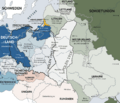
After the war, the Treaty of Versailles changed Germany's borders. Most of West Prussia was given to Poland, creating the "Polish Corridor" that separated East Prussia from the rest of Germany. The Klaipėda Region was also separated and later joined Lithuania in 1923.
In 1920, people in eastern West Prussia and southern East Prussia voted on whether to join Poland or stay with Germany. Most voted to remain part of Germany.
Nazi Germany Period

When Adolf Hitler and the Nazi Party came to power, they persecuted political opponents. Erich Koch led the Nazi party in East Prussia. He was known for being very strict. The Nazis also changed many place names in East Prussia in 1938, making them sound more German.
In 1939, the Klaipėda Region was taken back by Germany and became part of East Prussia again.
World War II and Division

During World War II, East Prussia's borders changed again. Parts of Poland were added to East Prussia. In 1939, East Prussia had about 2.5 million people. Most were Germans, but there were also Polish and Lithuanian minorities. The Nazis persecuted Polish minorities and Jewish people. Jewish residents were sent to concentration camps and killed.
Hitler's secret military headquarters, the Wolf's Lair, was located in East Prussia. The Polish resistance was also active in the region.
East Prussia was not heavily affected by the war until January 1945. Then, the Red Army advanced, leading to the East Prussian Offensive. Many inhabitants became refugees, fleeing in the cold winter.
Evacuation of East Prussia

In 1944, the city of Königsberg was almost completely destroyed by British air raids. The Nazi leader, Erich Koch, delayed the evacuation of civilians. This meant many people were caught by the advancing Red Army.
Reports of harsh treatment by Soviet soldiers caused great fear. Thousands of people died during the evacuation, including many who drowned when ships like the Wilhelm Gustloff were sunk. Königsberg surrendered in April 1945. It is estimated that about 300,000 people died during the war and its aftermath in East Prussia. However, most German residents managed to escape.
East Prussia After 1945
After Germany's defeat in 1945, East Prussia was divided. The southern part went to Poland, and the northern part went to the Soviet Union. The city of Königsberg was renamed Kaliningrad in 1946.
Most of the German population had already left or were moved out after the war. Many who tried to return were prevented. Orphaned children left behind were called Wolf children.
Southern East Prussia to Poland
The Polish government took control of southern East Prussia in May 1945. Polish people who had been forced to leave their homes in other areas, as well as Ukrainians, settled there. This area is now mostly part of the Warmian-Masurian Voivodeship in Poland.
Many of the remaining original inhabitants, who were seen as Germanized Poles, later moved to West Germany. Polish names were restored to many towns and places.
Northern Part to the Soviet Union


In April 1946, northern East Prussia became the "Kyonigsbergskaya Oblast" of the Russian Soviet Federative Socialist Republic. The Klaipėda Region became part of Lithuania. The historic city of Königsberg was renamed Kaliningrad in July 1946.
The Soviet authorities removed almost all traces of German history. All German place names were changed to Russian ones. The area became a military zone, closed to foreigners. In 1967, the remains of Königsberg Castle were torn down.
Modern Status
Today, the Kaliningrad Oblast is part of Russia. The Polish part of the region is now the Warmian-Masurian Voivodeship. Since 2004, Poland and Lithuania are part of the European Union. This means people can travel freely between these areas.
Demographics and Languages
In 1824, East Prussia had about 1 million people. Slightly more than half were German. About 26% were Polish, and 19% were Lithuanian. There were also smaller groups like Curonians and Latvians. Most Polish and Lithuanian inhabitants were Lutherans, unlike their Catholic relatives in Poland.
By 1905, the province was divided into three main regions. The majority of people spoke German. However, Polish was widely spoken in the south, especially in Masuria and Warmia. Lithuanian was spoken in the northeast, in Lithuania Minor. The original Old Prussian language had died out by the 18th century.
Images for kids
-
An illustration of the changing borders in Eastern Europe before, during, and after World War II (Map is written in German.)
-

Changes in Germany's borders as a result of both World Wars, with the partition of East Prussia


See also
 In Spanish: Prusia Oriental para niños
