East Savanna River facts for kids
Quick facts for kids East Savanna River |
|
|---|---|
| Country | United States |
| Physical characteristics | |
| Main source | Wolf Lake, Aitkin County, Minnesota 1,266 feet (386 m) |
| River mouth | 1,230 feet (370 m) |
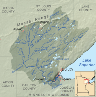
The East Savanna River is a small but important stream in Aitkin and Saint Louis counties in the U.S. state of Minnesota. It is about 15.3 miles (24.6 km) long. The river starts in Wolf Lake, a small lake in a bog within Savanna Portage State Park. It then flows northeast to the Saint Louis River near Floodwood. From there, its waters travel to Lake Superior, then through the Great Lakes and the Saint Lawrence River to the Atlantic Ocean.
Thousands of years ago, the East Savanna River was actually part of the Mississippi River! It used to start in northeast Minnesota and flow southwest to Big Sandy Lake. From Big Sandy Lake, the mighty Mississippi continued its journey to the Gulf of Mexico.
Today, a low area of land separates the Mississippi River's water from the East Savanna River's water. This area was once a famous trade route. Fur traders and explorers used it to connect the Great Lakes to the Mississippi River. Part of this old route, including where the East and West Savanna Rivers begin, is now inside Savanna Portage State Park.
Contents
What's in a Name?
The river's name, la Savanne, comes from French explorers. The West Savanna River, which is very close by, also shares this name. The French word "savanne" originally came from a Native American word. It meant a "treeless area."
This name was used for the marshy grasslands where the river starts and flows. These areas have very few trees. The Ojibwe people had a more exact name for the river: Mashkiig-onigami-ziibi. This means "marsh-portage river."
How the River Changed Course
After the last big glacier melted, a large lake called Lake Upham formed. When this lake dried up, its water first flowed into the Mississippi River. The Mississippi River actually started in the northeast, where the Saint Louis River is today. It flowed southwest along the path of what is now the East Savanna River.
But then, something cool happened called "stream piracy." Imagine one river "stealing" water from another! The smaller Saint Louis River slowly carved its way upstream. It first captured the Cloquet River. Then, it captured the Mississippi River's eastern part, changing its flow southeast to Lake Superior.
Because of this "piracy," the East Savanna River actually reversed its flow! It used to be the upper Mississippi, flowing southwest towards the Gulf of Mexico. But after the Saint Louis River eroded its way to Floodwood, the East Savanna became a small river flowing northeast. Now, it's a part of the Saint Louis River's system, which leads to the Atlantic Ocean.
River Life and Landscape
The area around the East Savanna River is part of a larger region called the Laurentian Mixed Forest. The soil here is made of peat, silt, and sand. These came from the old glacial lake. The peat is found in the marshes, which are very common near the river's start. These marshes were once known as the "Great Savannah."
Further downstream, the river used to wind through a mixed forest. It had clay banks and many trees, some dropped by beavers.
Today, the river flows through a channel that humans dug. This channel is called "Judicial Ditch No. 3." It was made to try and drain the marsh for farming. However, it didn't work. People said, "The land is still hopeless swamp, and so far as anyone can now see will always remain so." As the river leaves Savanna Portage State Park, the land becomes a bit higher. The new channel cuts through the old, natural bends of the river.
A Historic Trade Route
The East Savanna River was a key part of the Northwest Trail. This trail was a historic trade route between the Great Lakes and the Mississippi River basin. Native American groups, and later fur traders, missionaries, and explorers, used this route.
They would travel up the Saint Louis River from Fond du Lac (near modern Duluth, Minnesota). Then, they would go up the East Savanna River to the Savanna Portage. A "portage" is a place where you carry your canoe or boat over land between two waterways. After crossing the portage and the drainage divide, they would reach the West Savanna River. From there, they would go down to the Prairie River and Big Sandy Lake, finally reaching the Mississippi River.
Before humans dug channels, the winding river was about 24 miles (39 km) long from the Saint Louis River to the start of the portage. Muskeg Lake, south of the portage, was once thought to be the river's source. Both Wolf and Muskeg Lakes were open areas within the huge, swampy "Great Savannah." Travelers used the portage to avoid the worst parts of this swamp. Now, with the new channels, Muskeg Lake is no longer open water. The distance from the portage to the river's end is only 15.3 miles (24.6 km) because many of the river's natural bends have been removed.
 | James Van Der Zee |
 | Alma Thomas |
 | Ellis Wilson |
 | Margaret Taylor-Burroughs |


