Proglacial lakes of Minnesota facts for kids

Imagine a time when huge sheets of ice covered much of North America! As these giant glaciers, called the Laurentide Ice Sheet, slowly melted away at the end of the last Ice Age, they left behind many lakes in what is now Minnesota. These lakes are called proglacial lakes because they formed right in front of the melting ice.
We know these lakes existed because of the flat land and special layers of sand and clay they left behind. These ancient lakes didn't all exist at the same time. They formed, grew, and then drained away as the ice continued to melt and new paths for the water opened up. Some were enormous, like Glacial Lake Agassiz, which was the biggest freshwater lake ever known in North America! There were also many smaller lakes that appeared and disappeared as the ice sheet moved north.
Contents
Glacial Lake Agassiz: A Giant Lake
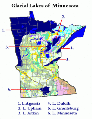
Glacial Lake Agassiz was truly massive. It was bigger than all of today's Great Lakes put together! This huge lake stretched from Browns Valley, Minnesota west into South Dakota and North Dakota. It also went far north into Canada, covering parts of Saskatchewan, Manitoba, and Ontario.
In Minnesota, Lake Agassiz filled the Red River Valley in the northwest. It also covered parts of the Rainy River area in the northern part of the state. The water from Lake Agassiz flowed south through a channel called the Traverse Gap. This channel was carved by a huge river, the Glacial River Warren. This ancient river created the valleys where the Minnesota River and the Upper Mississippi River flow today.
Some parts of Glacial Lake Agassiz still exist! Today, you can see its remnants in lakes like Lake of the Woods and Upper and Lower Red Lake.
Glacial Lake Upham: A Boggy Past
Glacial Lake Upham formed as another part of the giant ice sheet, called the St. Louis Sublobe, melted away. This lake drained its water into Glacial Lake Duluth through several paths. Today, the area where Lake Upham once was is a large, wet, and boggy place. It makes up a big part of the area where the Rainy River flows.
Glacial Lake Aitkin: A Source of Peat
Glacial Lake Aitkin also formed when the St. Louis Sublobe of the glacier retreated. For a long time, it was connected to Glacial Lake Upham. This lake filled a wide, low area along the Mississippi River valley. This was between Grand Rapids and Aitkin in north-central Minnesota.
The land where this lake used to be is now a mix of sand and clay. It's also a place where a special kind of soil called reed-sedge peat is found. This peat is harvested and used in farming. It helps plants get nitrogen, which means farmers need less fertilizer. Scientists are even working on ways to use this peat to clean water. They are trying to remove things like mercury and other heavy metals from water. They also want to remove sulfates, and they are developing a method that allows the peat to be used again and again!
Glacial Lake Duluth: The Ancestor of Lake Superior
Glacial Lake Duluth was the largest of several lakes that filled parts of the western Lake Superior basin. The city of Duluth has a famous flat area, or terrace, that was created by the waves of Glacial Lake Duluth. Skyline Parkway was built along this old shoreline.
Because the ice sheet blocked lower paths to the east, Lake Duluth had to drain in other directions. Its water flowed across the Laurentian Divide into the valleys of the Saint Croix River and the Mississippi. One path was through the Nemadji River basin, then down the Moose and Kettle Rivers. Another path was through the modern Bois Brule River to the Saint Croix.
The highest level of Glacial Lake Duluth was about 1060 feet (323 meters) in Duluth. But it rose even higher, up to 1350 feet (411 meters), near the border with Ontario. When the glacier finally moved away, the lake could drain east into the Lake Michigan basin. This happened through paths across the upper Peninsula of Michigan.
Glacial Lake Grantsburg: Blocked by Ice
Glacial Lake Grantsburg formed when a part of the glacier, called the Grantsburg Sublobe, blocked the water from flowing south. This lake stretched from St. Cloud east-northeast to Grantsburg, Wisconsin. From there, its water flowed south along the edge of the ice sheet. It followed the valley of the Saint Croix River.
Glacial Lake Minnesota: Lakes on Ice
Glacial Lake Minnesota was actually a group of lakes. They formed on or near the Des Moines Lobe of the glacier, generally south of Mankato, Minnesota. We know about these lakes because of the special lake sediments found in that area. These lakes might have been bodies of water trapped on top of the melting ice. They could also have been lakes that formed as the glacier retreated. Or they might have been low areas filled by the overflow from the giant Glacial River Warren.
 | Sharif Bey |
 | Hale Woodruff |
 | Richmond Barthé |
 | Purvis Young |

