Westlock County facts for kids
Quick facts for kids
Westlock County
|
||
|---|---|---|
|
||

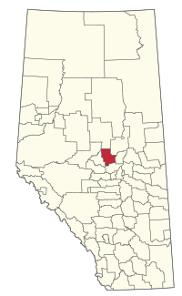
Location within Alberta
|
||
| Country | Canada | |
| Province | Alberta | |
| Region | Central Alberta | |
| Planning region | North Saskatchewan | |
| Established | 1943 | |
| Incorporated | 1998 | |
| Area
(2021)
|
||
| • Land | 3,169.66 km2 (1,223.81 sq mi) | |
| Population
(2021)
|
||
| • Total | 7,186 | |
| • Density | 2.3/km2 (6/sq mi) | |
| Time zone | UTC−7 (MST) | |
| • Summer (DST) | UTC−6 (MDT) | |
Westlock County is a special type of local government area called a municipal district in Alberta, Canada. It is located just north of the city of Edmonton. This area was once known as the Municipal District of Westlock No. 92. It was created in 1943 when five smaller municipal districts joined together.
Contents
Exploring Westlock County's Landscape
Rivers and Waterways
Westlock County is unique because it sits on the edge of two huge drainage basins. A drainage basin is like a giant bowl where all the rain and melted snow flow into one main river.
- The northern and western parts of the county send their water to the Pembina River. This river flows north and eventually joins the Athabasca River. The Athabasca River then empties into the Arctic Ocean through the Mackenzie River.
- The southern and eastern parts of the county drain into the Sturgeon River. This river connects to the North Saskatchewan River, which then flows into Hudson Bay via the Nelson River.
Natural Areas and Plains
In 1986, maps showed that Westlock County is on the northwestern edge of the Eastern Alberta Plains. This means the land is mostly flat or gently rolling.
- The county includes parts of the Edmonton Plain and the Tawatinaw Plain.
- To the northwest, it borders the Athabasca Valley, which is the area around the Athabasca River.
- Westlock County is also part of the Aspen Parkland. This is a special biome (a large natural area with similar plants and animals). It's a mix of trees and open grasslands, found between the thick boreal forest of Canada to the north and the wide prairie to the south.
Communities in Westlock County
Westlock County is home to several towns, villages, and hamlets. Some of these are surrounded by the county, while others are part of it.
Urban Areas Near the County
These are towns and villages that are separate from the county but are located within its boundaries.
Hamlets Within the County
Hamlets are smaller communities that are directly part of Westlock County.
Other Localities
Westlock County also has many smaller places called localities. These are often just a few homes or a crossroads.
- Analta
- Anton Lake
- Arvilla
- Deeney
- Eastburg
- Eunice
- Fawn Lake
- French Creek
- Halach
- Halcreek
- Halfway Lake
- Jeffrey
- Linaria
- Pembina Heights
- Regal Park
- Rossington
- Shoal Creek
- Sylvan Glen
- Waugh
How Many People Live Here?
We can learn about the population of Westlock County from the official Statistics Canada census.
Population in 2021
In the 2021 Census, Westlock County had a population of 7,186 people. These people lived in 2,680 homes. The total number of homes available was 3,134. This population was a small decrease from 2016. The county covers about 3,169.66 square kilometers (1,223.81 square miles). This means there were about 2.3 people per square kilometer.
Population in 2016
In the 2016 Census, Westlock County had 7,220 people. They lived in 2,670 homes out of 3,009 total homes. This was a decrease from its 2011 population of 7,644. The land area was about 3,171.83 square kilometers (1,224.65 square miles). The population density was about 2.3 people per square kilometer.
Education in Westlock County
The schools in Westlock County are part of the Pembina Hills Public Schools system. This school district was formed in 1995. It was created by combining three smaller school districts.


