
Eder facts for kids
The Eder is a 177-kilometer (about 110-mile) long river in Germany. It starts in eastern North Rhine-Westphalia and then flows into Hesse. In Hesse, it joins another river called the Fulda.
Quick facts for kids Eder |
|
|---|---|

The Eder in Edersee when the lake dried out in 2003
|
|

Map of the Eder, its tributaries and water catchment area
|
|
| Native name | Eder |
| Other name(s) | Edder |
| Country | Germany |
| States | North Rhine-Westphalia-Hesse |
| Physical characteristics | |
| Main source | Ederkopf 634 m (2,080 ft) |
| River mouth | Edermünde 142 m (466 ft) 51°13′00″N 9°27′18″E / 51.216677°N 9.455075°E |
| Length | 176.1 km (109.4 mi) |
| Basin features | |
| Progression | Fulda→ Weser→ North Sea |
| Basin size | 3,362 km2 (1,298 sq mi) |
| Tributaries |
|
Contents
History of the Eder River
The Eder river was first written about by a Roman historian named Tacitus. This was around 15 AD. In his writings, called Annals, he described a Roman army campaign. The Roman army, led by Germanicus, fought against a group of people called the Chatti. After crossing the river, which they called Adrana, the Roman soldiers destroyed the main city of the Chatti, called Mattium.
In the Middle Ages, which was a long time ago, the river was known by different names. Some of these names were Aderna, Adarna, and Adrina.
In August 1708, a religious group called the Schwarzenau Brethren was started near the Eder river. This happened in a town called Schwarzenau. Eight grown-ups were fully baptized three times in the Eder river. This group later moved to America, where they still exist today.
Even up to the late 1800s, people in the local area sometimes called the river Edder. For example, in a place called Felsberg-Gensungen, there is a pharmacy still known as the Edder-Apotheke.
Gold in the Eder River
The sand and dirt at the bottom of the Eder river contain tiny bits of gold. Most of this gold is thought to come from a place called Eisenberg (Korbach). Eisenberg has one of the biggest gold reserves in central Europe. The gold washes out of Eisenberg, for example, by the Itter stream. This stream now flows into the Edersee lake, which was formed by a dam.
People have been panning for gold in the Eder since 1308. The main area where people historically looked for gold was between Affoldern and Fritzlar. In the 1300s, a group of knights called the Teutonic Knights also panned for gold near Obermöllrich. In the 1700s, special gold coins called ducats were even made from Eder gold. These coins are now very special collector's items.
Up until the 1970s, school children from Duisburg would go gold panning in the Itter river. They stayed at a nearby holiday camp and went with a teacher. Panning for gold along the Eder river is still a popular activity today.
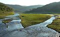
Course of the Eder River
The Eder river starts high up on the Ederkopf mountain. This mountain is part of the Rothaar mountain range in eastern North Rhine-Westphalia. It's close to where the Lahn and Sieg rivers also begin. However, the Eder flows differently. The Lahn and Sieg rivers flow into the Rhine river. But the Eder flows east and then north. It joins the Fulda river at Edermünde, which is south of Kassel. The Fulda river then meets the Werra river at Hann. Münden. Together, they form the Weser River, which eventually flows into the North Sea.
Edersee Dam
The Edersee Dam is located near the town of Waldeck. It is built from rock and concrete. The dam is 47 meters (about 154 feet) high and 400 meters (about 1,312 feet) long. It was finished in 1914, so it celebrated its 100th birthday in 2014. The dam creates the Edersee lake, which is 27 kilometers (about 17 miles) long. This lake holds 200 million cubic meters of water. This water is used to make hydroelectricity (power from water). It also helps control the water levels for ships on the Weser river.
When the water level is low, like in late summer or during dry years, you can see parts of three old villages. These villages (Asel, Bringhausen, and Berich) and a bridge were covered by water when the lake was filled in 1914. People whose ancestors were buried there sometimes visit the old grave sites.
Destruction of the Eder Dam
On the night of May 17, 1943, during World War II, something amazing happened. Avro Lancaster bombers from the RAF 617 Squadron used special "bouncing bombs." These bombs were designed by Barnes Wallis. They were used to destroy the Möhne and Eder dams. This mission was called Operation Chastise. The Eder dam was repaired and working again before the end of that same year. The story of this raid was even made into a movie in 1955 called The Dam Busters.
Images for kids
-
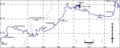
Map showing the path of the River Eder
-
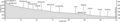
The river profile of the Eder, showing its elevation changes
-
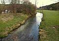
The Eder river at Goddelsbach
-
The Eder river near Frankenberg
-
The Eder river in the Edersee at low water near Asel
-
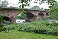
The sandstone bridge over the Eder between Altenbrunslar and Neuenbrunslar
-
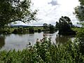
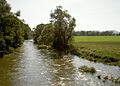
The Eder river (on the right) joining the Fulda river near Grifte


See also
 In Spanish: Eder para niños
