Elk River (Tennessee River tributary) facts for kids
Quick facts for kids Elk River |
|
|---|---|

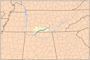
Elk River watershed
|
|
| Country | United States |
| State | Tennessee, Alabama |
| Physical characteristics | |
| Main source | Junction of Laurel and Jay Creeks Cumberland Plateau, Tennessee 1,010 ft (310 m) 35°21′37″N 85°50′10″W / 35.36028°N 85.83611°W |
| River mouth | Tennessee River Wheeler Lake, Alabama 558 ft (170 m) 34°45′41″N 87°15′56″W / 34.76139°N 87.26556°W |
| Length | 195 mi (314 km) |
The Elk River is a river in the United States. It flows through parts of Tennessee and Alabama. This river is about 195 miles (314 km) long. It eventually joins the Tennessee River.
Contents
Where the Elk River Flows
The Elk River starts in Grundy County, Tennessee. It begins in a place called Burroughs Cove, near Elkhead. One of the first bridges over it is State Route 50 near Pelham, Tennessee.
At first, the river flows southwest. Then it turns and flows more towards the west. It goes under U.S. Route 41 and Interstate 24. Soon after, it forms the border between Coffee County and Franklin County.
Woods Reservoir
The river is first blocked by the Elk River Dam. This creates a large lake called Woods Reservoir. This lake stretches upstream to where the river stops being the county line. The entire reservoir is within Franklin County.
The United States Army Corps of Engineers built this reservoir. Its main purpose was to provide cooling water. This water is used for the U.S. Air Force's Arnold Engineering Development Center. This center has huge wind tunnels and other research equipment. The area around the reservoir is also a wildlife refuge. State Route 127 crosses the reservoir.
Tims Ford Lake
Just a few miles below Elk River Dam, the water slows down. This slow water forms Tims Ford Lake. This lake was created by the Tims Ford Dam. The Tennessee Valley Authority built this dam.
The slow water of Tims Ford Lake reaches upstream to Estill Springs. U.S. Route 41A crosses the lake. Parts of the Tims Ford project also reach into Winchester. Winchester is the main town of Franklin County. The main part of the Elk River flows west of Winchester. State Route 130 crosses the river there.
Some water from the reservoir leaks out. It appears as large springs along State Route 50. This happens because the water seeps through the limestone rock in the area. Local people sometimes use this water for livestock. State Route 50 crosses the Elk River again, just below Tims Ford Dam.
Journey to the Tennessee River
Soon after the dam, the river becomes a border. It separates Franklin County from Moore County. Then it separates Moore County from Lincoln County. The river starts to curve a lot, forming many bends.
Near a small community called Kelso, U.S. Route 64 crosses the river. Kelso has a cave that was used to mine saltpeter. This was done by Confederates during the Civil War.
The Elk River flows just south of Fayetteville. There, U.S. Route 231 and U.S. Route 431 cross it. Years ago, there was a special stone bridge over the Elk. It was built without mortar, using only the weight of the stones. A flood destroyed it in the late 1960s.
Several miles west of Fayetteville, State Route 274 crosses the river. This highway was built on an old railroad bed. The river then flows into Giles County. Here, CSX Transportation and Interstate 65 cross it. It flows just south of Elkton, Tennessee. U.S. Route 31 crosses the river there. A few miles later, it enters Limestone County, Alabama. Finally, it joins the Tennessee River.
Other Elk River
It's interesting to know that there are two Elk Rivers in Tennessee. The other one is smaller. It is located in northeast Tennessee. This Elk River starts in North Carolina. It flows through Carter County, Tennessee. It then empties into Watauga Lake.
Fun Things to Do on the Elk River
In Limestone County, Alabama, there is a fun trail. It is 21.9 miles (35.2 km) long. This trail is perfect for canoeing and kayaking. The trail starts at the Alabama-Tennessee state line. It goes all the way to Elk River Mills.
 | James Van Der Zee |
 | Alma Thomas |
 | Ellis Wilson |
 | Margaret Taylor-Burroughs |

