
Elkhorn, California facts for kids
Quick facts for kids
Elkhorn, California
|
|
|---|---|

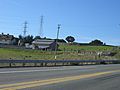
Population sign on Dolan Road
|
|

Location in Monterey County and the state of California
|
|

Elkhorn, California
Location in the United States
|
|
| Country | |
| State | |
| County | Monterey |
| Area | |
| • Total | 4.825 sq mi (12.50 km2) |
| • Land | 4.803 sq mi (12.44 km2) |
| • Water | 0.022 sq mi (0.06 km2) 0.46% |
| Elevation | 10 ft (3 m) |
| Population
(2020)
|
|
| • Total | 1,588 |
| • Density | 330.6/sq mi (127.6/km2) |
| Time zone | UTC-8 (PST) |
| • Summer (DST) | UTC-7 (PDT) |
| ZIP codes | |
| Area code(s) | 831 |
| FIPS code | 06-22034 |
| GNIS feature ID | 277507, 2408075 |
Elkhorn is a small community in Monterey County, California, United States. It's known as a census-designated place (CDP), which means it's an area that looks like a town but isn't officially governed by its own local government.
Elkhorn started as a train stop on the Southern Pacific Railroad. It was about 4 miles (6 km) north of Castroville. The community is named after the elk that used to live in the area, but these animals are now extinct there. In 2020, about 1,588 people lived in Elkhorn.
Contents
Geography of Elkhorn
Elkhorn is located in the northern part of Monterey County. It is about 14 miles (23 km) northwest of Salinas, which is the county seat. It's also 7 miles (11 km) south of Watsonville and 22 miles (35 km) northeast of Monterey.
The community gets its mail through the ZIP Code areas of nearby towns: 95012 (Castroville) and 93907 (Prunedale / Salinas).
Elkhorn Slough and Nature
A very important natural area called Elkhorn Slough is next to Elkhorn. This slough is the biggest tidal salt marsh in the area, besides San Francisco Bay. A salt marsh is a coastal wetland that is flooded and drained by salt water brought in by the tides.
The Elkhorn Slough National Estuarine Research Reserve works to teach people about and protect this special salt marsh environment. It's a great place to learn about nature.
Land and Water Areas
According to the United States Census Bureau, the Elkhorn CDP covers a total area of about 4.8 square miles (12.4 square kilometers). Most of this area is land, with only a small part, about 0.02 square miles (0.05 square kilometers), being water.
Main Roads in Elkhorn
Several important roads run through Elkhorn. These include Castroville Boulevard, Dolan Road, Elkhorn Road, and Meridian Road.
- Castroville Boulevard goes southwest to Highway 156 and east towards Prunedale and U.S. Route 101.
- Dolan Road leads west to Highway 1.
Other smaller roads in the area include Del Monte Farms, Bayview Road, Walker Valley Road, Long Valley Road, Amaral Road, and Paradise Canyon Road.
Elkhorn's Population
| Historical population | |||
|---|---|---|---|
| Census | Pop. | %± | |
| 1990 | 1,458 | — | |
| 2000 | 1,591 | 9.1% | |
| 2010 | 1,565 | −1.6% | |
| 2020 | 1,588 | 1.5% | |
| source: | |||
Population in 2010
In 2010, Elkhorn had a population of 1,565 people. The community had about 324 people per square mile.
- Most residents (71.7%) were White.
- About 18.3% were from other races, and 4.8% were from two or more races.
- A significant portion, 37.6%, identified as Hispanic or Latino.
There were 532 households in Elkhorn.
- About 34.4% of these households had children under 18 living there.
- Most households (61.8%) were married couples.
- The average household had about 2.94 people.
The median age in Elkhorn was 41.5 years.
- About 23.3% of the population was under 18 years old.
- About 11.8% of the population was 65 years or older.
Most homes (71.4%) were owned by the people living in them, while 28.6% were rented.
Population in 2000
In 2000, Elkhorn had 1,591 people living there. The population density was about 327 people per square mile.
- Most homes in Elkhorn are detached single-family houses. They often have their own water wells and leach fields for wastewater.
- About 72.16% of the population was White.
- About 27.91% of the population was Hispanic or Latino.
The median household income in 2000 was $70,370. The median age was 38 years.
Economy in Elkhorn

Agriculture is a very important part of Elkhorn's economy. Farmers in the area grow crops like strawberries and artichokes.
Most people who live in Elkhorn work in nearby towns such as Castroville, Prunedale, and Moss Landing. Many also work in larger cities like Watsonville, Salinas, and Monterey.
Elkhorn has very few businesses or stores. The only retail store is the Elkhorn Superette. For most shopping, like department stores or movie theaters, residents travel to Castroville or other larger cities about 20 minutes away.
Education in Elkhorn
Elkhorn has one school, Elkhorn Elementary School. It serves students from kindergarten through 6th grade. This school is also where people in Elkhorn go to vote.
After elementary school, students in 7th and 8th grade attend North Monterey County Middle School. High school students (grades 9-12) go to North Monterey County High School. Both of these schools are located in Castroville. All public schools in the area are part of the North Monterey County Unified School District [1].
Images for kids
-
Dolan Road
-
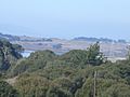
Elkhorn Slough in the distance
-
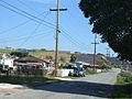
Homes near Castroville Blvd.
-
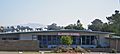
Elkhorn Elementary


See also
 In Spanish: Elkhorn (California) para niños
