North Hanover Township, New Jersey facts for kids
Quick facts for kids
North Hanover Township, New Jersey
|
||
|---|---|---|
|
Township
|
||
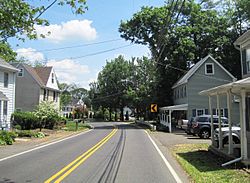
Jacobstown, a settlement within the township
|
||
|
||
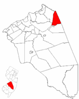
North Hanover Township highlighted in Burlington County. Inset map: Burlington County highlighted in the State of New Jersey.
|
||
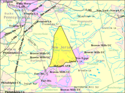
Census Bureau map of North Hanover Township, New Jersey
|
||
| Country | ||
| State | ||
| County | ||
| Incorporated | April 12, 1905 | |
| Government | ||
| • Type | Township | |
| • Body | Township Committee | |
| Area | ||
| • Total | 17.51 sq mi (45.35 km2) | |
| • Land | 17.37 sq mi (44.98 km2) | |
| • Water | 0.14 sq mi (0.37 km2) 0.81% | |
| Area rank | 164th of 565 in state 15th of 40 in county |
|
| Elevation | 154 ft (47 m) | |
| Population
(2020)
|
||
| • Total | 7,963 | |
| • Estimate
(2023)
|
8,007 | |
| • Rank | 294th of 565 in state 22nd of 40 in county |
|
| • Density | 458.5/sq mi (177.0/km2) | |
| • Density rank | 445th of 565 in state 28th of 40 in county |
|
| Time zone | UTC−05:00 (Eastern (EST)) | |
| • Summer (DST) | UTC−04:00 (Eastern (EDT)) | |
| ZIP Code |
08562
|
|
| Area code(s) | 609 exchanges: 723, 724, 752, 758 | |
| FIPS code | 3400553070 | |
| GNIS feature ID | 0882087 | |
| Website | ||
North Hanover Township is a community located in Burlington County, New Jersey. It's a type of local government called a township. In 2020, about 7,963 people lived here. This number was a bit higher than in 2010. North Hanover Township is part of a larger area that includes big cities like Philadelphia, Pennsylvania, and Camden, New Jersey.
North Hanover Township became an official township on April 12, 1905. It was created from parts of another township called New Hanover Township. Later, in 1918, a small part of North Hanover Township was used to form the town of Wrightstown.
Contents
Geography of North Hanover Township
North Hanover Township covers about 17.51 square miles (45.35 square kilometers). Most of this area is land, with a small amount of water.
Communities and Neighbors
A part of McGuire Air Force Base is located within North Hanover Township. This base is a community where many people live. In 2010, about 2,973 people on the base lived in the North Hanover portion.
Other small communities and places you might find in the township include:
- Arneytown
- Ellisdale
- Jacobstown
- Sykesville
- Wrightstown
The township shares borders with several other towns. These include Chesterfield Township, New Hanover Township, and Springfield Township in Burlington County. It also borders Hamilton Township in Mercer County, Upper Freehold Township in Monmouth County, and Plumsted Township in Ocean County.
The Pinelands National Reserve
North Hanover Township is special because it's part of the New Jersey Pinelands National Reserve. This is a huge protected natural area with unique plants and animals. It covers over a million acres! The Pinelands is recognized as a United States Biosphere Reserve. It was set up in 1978 to protect this important natural environment.
Population and People
| Historical population | |||
|---|---|---|---|
| Census | Pop. | %± | |
| 1910 | 696 | — | |
| 1920 | 651 | * | −6.5% |
| 1930 | 675 | 3.7% | |
| 1940 | 731 | 8.3% | |
| 1950 | 1,155 | 58.0% | |
| 1960 | 2,796 | 142.1% | |
| 1970 | 9,858 | 252.6% | |
| 1980 | 9,050 | −8.2% | |
| 1990 | 9,994 | 10.4% | |
| 2000 | 7,347 | −26.5% | |
| 2010 | 7,678 | 4.5% | |
| 2020 | 7,963 | 3.7% | |
| 2023 (est.) | 8,007 | 4.3% | |
| Population sources: 1910–2000 1910–1920 1910 1910–1930 1940–2000 2000 2010 2020 * = Lost territory in previous decade. |
|||
The population of North Hanover Township has changed over the years. In 1910, there were 696 people. By 2020, the population had grown to 7,963.
Diversity in North Hanover
According to the 2010 census, the people living in North Hanover Township come from many different backgrounds.
- About 80% of the population was White.
- Around 9% was Black or African American.
- About 2% was Asian.
- Other groups made up smaller percentages.
- About 10% of the population identified as Hispanic or Latino.
Many households in the township have children under 18. The average household had about 2.76 people.
Education in North Hanover Township
Children in North Hanover Township attend public schools. The school system is divided into two main districts based on age.
Elementary and Middle School
Students from pre-kindergarten through sixth grade go to schools in the North Hanover Township School District. This district has three schools:
- Endeavour Elementary School: For PreK-4 students, located on Joint Base McGuire-Dix-Lakehurst.
- Clarence B. Lamb Elementary School: For PreK-4 students, located in Jacobstown.
- North Hanover Township Upper Elementary School: For 5th and 6th graders, also in Jacobstown.
In the 2020-2021 school year, about 1,127 students were enrolled in these three schools.
High School
Students in seventh through twelfth grades attend schools in the Northern Burlington County Regional School District. This district also serves students from nearby towns like Chesterfield, Mansfield, and Springfield. Children of military families at Joint Base McGuire-Dix-Lakehurst also attend these schools.
The high school district has two schools:
- Northern Burlington County Regional Middle School: For 7th and 8th graders.
- Northern Burlington County Regional High School: For 9th through 12th graders.
Both of these schools are located in the Columbus section of Mansfield Township.
Vocational and Technical Education
Students in Burlington County, including those from North Hanover Township, can also choose to attend the Burlington County Institute of Technology. This school offers vocational and technical programs for high school students and adults. It has campuses in Medford and Westampton.
Transportation
North Hanover Township has many roads. As of 2010, there were about 42.75 miles of roadways. The township maintains some roads, and Burlington County maintains others.
Main Roads
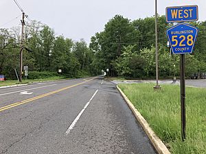
No major interstate highways or U.S. routes pass directly through North Hanover Township. The two main county roads that go through the township are County Road 528 and County Road 537.
Larger highways like Interstate 295 and Interstate 195 can be accessed in nearby towns. The New Jersey Turnpike is also close by, with an exit in Bordentown Township.
Public Bus Service
NJ Transit provides bus service in the township. The 317 bus route connects North Hanover Township to places like Asbury Park and Philadelphia.
Notable People
People who have lived in or are connected to North Hanover Township include:
- Joe Borden (1854–1929): A professional baseball player who played in the 1870s.
- George Sykes (1806–1880): A politician who represented New Jersey in the United States House of Representatives in the 1840s.
See also
 In Spanish: Municipio de North Hanover para niños


