
Chesterfield Township, New Jersey facts for kids
Quick facts for kids
Chesterfield Township, New Jersey
|
||
|---|---|---|
|
Township
|
||

John Newbold House,
the Inn at Fernbrook Farms |
||
|
||

Location of Chesterfield Township in Burlington County highlighted in red (right). Inset map: Location of Burlington County in New Jersey highlighted in red (left).
|
||

Census Bureau map of Chesterfield Township, New Jersey
|
||

Chesterfield Township, New Jersey
Location in Burlington County, New Jersey

Chesterfield Township, New Jersey
Location in New Jersey

Chesterfield Township, New Jersey
Location in the United States
|
||
| Country | ||
| State | ||
| County | Burlington | |
| Formed | November 6, 1688 | |
| Royal charter | January 10, 1713 | |
| Incorporated | February 21, 1798 | |
| Named for | Chesterfield, Derbyshire, England | |
| Government | ||
| • Type | Township | |
| • Body | Township Committee | |
| Area | ||
| • Total | 21.45 sq mi (55.57 km2) | |
| • Land | 21.31 sq mi (55.20 km2) | |
| • Water | 0.14 sq mi (0.37 km2) 0.67% | |
| Area rank | 131st of 565 in state 14th of 40 in county |
|
| Elevation | 92 ft (28 m) | |
| Population
(2020)
|
||
| • Total | 9,422 | |
| • Estimate
(2023)
|
9,330 | |
| • Rank | 253rd of 565 in state 17th of 40 in county |
|
| • Density | 442.1/sq mi (170.7/km2) | |
| • Density rank | 448th of 565 in state 29th of 40 in county |
|
| Time zone | UTC−05:00 (Eastern (EST)) | |
| • Summer (DST) | UTC−04:00 (Eastern (EDT)) | |
| ZIP Code |
08515 – Crosswicks
|
|
| Area code(s) | 609 exchanges: 291, 298 | |
| FIPS code | 3400512670 | |
| GNIS feature ID | 0882109 | |
| Website | ||

Chesterfield Township is a community in Burlington County, New Jersey. It is known for its beautiful farmland. The township has worked hard to protect over 7,000 acres of farmland.
Chesterfield Township has a special plan to guide new buildings to a specific area. This area is called Old York Village. It is a modern community built on 560 acres. It has different types of homes, shops, a new elementary school, and open spaces. This helps keep the surrounding farmland safe. Construction started in the early 2000s and is mostly finished. Old York Village won a national award in 2004 for its smart planning.
As of the 2020 United States census, about 9,422 people live in Chesterfield Township. This was the highest number of people ever counted in the area. It shows a big increase from previous years. Chesterfield Township is part of the larger Philadelphia-Reading-Camden area.
Contents
History of Chesterfield Township

The first settlers arrived in Chesterfield Township in 1677. They were mostly Quaker immigrants from England. They started a community called Crosswicks. This is the oldest of the three main villages in the township. Crosswicks was named after the Crosswicks Creek. This creek separates Burlington and Mercer counties.
The other two early villages were Recklesstown and Plattsburg. Recklesstown is now known as Chesterfield. Plattsburg is now Sykesville. Recklesstown was named after Joseph Reckless, one of its founders. But the name was changed in 1888 because people didn't like it.
Chesterfield Township was officially formed on November 6, 1688. It was named after the 2nd Earl of Chesterfield. His home was in Chesterfield, England. Many of the first settlers came from that area. The township was later re-established by a special document from the King (a Royal charter) on January 10, 1713. It became one of New Jersey's first 104 townships on February 21, 1798. Over time, parts of Chesterfield Township were used to create other towns. These include New Hanover Township in 1723 and Bordentown borough in 1825.
Crosswicks played a part in the American Revolutionary War. In 1778, British soldiers shot the horse of Elias Dayton near Crosswicks Creek. He was a captain in the New Jersey army. You can still see a cannonball from that time stuck in the side of the Friends Meeting House.
Geography and Location
Chesterfield Township covers about 21.45 square miles (55.57 square kilometers). Most of this area is land, with a small amount of water.
Neighboring Towns
Chesterfield Township shares its borders with several other towns:
- In Burlington County: Bordentown Township, Mansfield Township, North Hanover Township, and Springfield Township.
- In Mercer County: Hamilton Township.
Communities within the Township
Some smaller communities and places located inside Chesterfield Township include:
- Chesterfield
- Crosswicks
- Davisville
- Extonville
Education in Chesterfield
Chesterfield Township has its own school district. Students in pre-kindergarten through sixth grade go to Chesterfield Elementary School.
Chesterfield Elementary School
- As of 2020–21, the school had 723 students.
- There were 67 teachers, meaning about 10.8 students per teacher.
- A new school building for grades K-6 opened in January 2011.
Northern Burlington County Regional School District
Students in seventh through twelfth grade attend schools in the Northern Burlington County Regional School District. This district also serves students from Mansfield, North Hanover, and Springfield townships. Children of military families from McGuire Air Force Base also attend these schools.
The schools in this district are:
- Northern Burlington County Regional Middle School (grades 7-8)
- Northern Burlington County Regional High School (grades 9-12)
Both of these schools are located in the Columbus section of Mansfield Township. Chesterfield Township helps pay for the district's costs. Two members from Chesterfield Township serve on the school board.
Vocational and Technical Education
Students from Chesterfield Township can also attend the Burlington County Institute of Technology. This school district offers special training for jobs and technical skills. It has campuses in Medford and Westampton Township.
Transportation
_from_the_overpass_for_Ward_Avenue_in_Chesterfield_Township,_Burlington_County,_New_Jersey.jpg)
As of 2010, Chesterfield Township had about 58.79 miles of roads.
- The township maintains 38.50 miles.
- Burlington County maintains 18.17 miles.
- The New Jersey Turnpike Authority maintains 2.12 miles.
Major Roads
Important county roads that go through Chesterfield Township include:
- Route 528
- Route 537
- Route 545
New Jersey Turnpike
The New Jersey Turnpike (Interstate 95) runs through the northwest part of the township. It enters from Bordentown Township and continues into Hamilton Township. The closest exit for the Turnpike is Exit 7 in Bordentown Township.
From 2004 to 2014, the Turnpike was made wider in this area. New lanes were added to help with traffic. This made it a 12-lane highway in some parts.
Public Transportation
There is no public transportation directly in Chesterfield Township. However, nearby towns offer options:
- In Bordentown, the RiverLINE train provides service to Camden and Trenton.
- In Hamilton Township, the Northeast Corridor Line train goes to Penn Station New York. Many people from Chesterfield Township use this for work.
Notable People from Chesterfield
Many interesting people have lived in or are connected to Chesterfield Township:
- Kenneth R. Blackmon (born around 1967), a United States Navy Rear Admiral. He has served as a leader for the United States Third Fleet.
- Antron Brown (born 1976), a famous drag racer. He was the first African American to win the 2012 Top Fuel championship in the National Hot Rod Association.
- Andrea Katz, a politician who serves in the New Jersey General Assembly. She represents the 8th legislative district since 2024.
- Charles Newbold (1764–1835), a blacksmith. In 1797, he received the first patent for a plow made of cast iron.
- Ely Playter (1776–1858), a farmer and lumberman. He was also a military officer and a member of the Upper Canada House of Assembly.
Images for kids
-
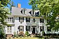
John Newbold House, the Inn at Fernbrook Farms
-
Seal of Chesterfield Township
-
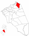
Location of Chesterfield Township in Burlington County
-
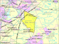
Census Bureau map of Chesterfield Township
See also
 In Spanish: Municipio de Chesterfield (Nueva Jersey) para niños
