
Fairholme Range facts for kids
Quick facts for kids Fairholme Range |
|
|---|---|

|
|
| Highest point | |
| Peak | Mount Girouard |
| Elevation | 2,995 m (9,826 ft) |
| Geography | |

Location in Alberta
|
|
| Country | Canada |
| Province | Alberta |
| Range coordinates | 51°08′59″N 115°19′36″W / 51.14972°N 115.32667°W |
| Parent range | Front Ranges |
The Fairholme Range is a group of mountains found in the Canadian Rockies. It is located east of the Bow River valley in Alberta, Canada.
This mountain range is bordered by the Trans-Canada Highway on its west side. This highway passes through the towns of Exshaw and Canmore. The northern part of the Fairholme Range reaches into Banff National Park. It extends all the way to the southern shores of Lake Minnewanka.
The Fairholme Range was named in 1859 by John Palliser. He named it after his sister, Grace Fairholme.
Contents
Exploring the Fairholme Range
The Fairholme Range is home to several impressive mountains. Many of these peaks are popular for hiking and climbing.
Tallest Peaks in the Range
Here are some of the highest mountains in the Fairholme Range:
| Mountain Peak | Height in Metres | Height in Feet |
|---|---|---|
| Mount Girouard | 2,995 | 9,827 |
| Mount Inglismaldie | 2,964 | 9,725 |
| Mount Peechee | 2,935 | 9,630 |
| Mount Charles Stewart | 2,809 | 9,216 |
| Grotto Mountain | 2,706 | 8,878 |
| Mount Lady Macdonald | 2,606 | 8,550 |
| Princess Margaret Mountain | 2,515 | 8,252 |
| Squaw's Tit | 2,514 | 8,250 |
A Name Change for Respect
One of the peaks, previously known as "Squaw's Tit," was set to be renamed. This change happened because the old name was considered offensive. It was seen as both racist and disrespectful to women.
In August 2020, discussions began with the Stoney Nakoda people. The goal was to find a new name that would be culturally appropriate. This effort shows how important it is to use names that respect everyone.
Taking Care of the Mountains
In the spring and summer of 2003, Parks Canada carried out a special project. They performed a prescribed burn in certain areas of the Fairholme Range. A prescribed burn is when experts carefully set small fires on purpose.
This was done for several important reasons:
- To reduce the risk of large, uncontrolled wildfires.
- To help manage the population of pine beetles, which can harm trees.
- To improve the living areas for sheep and other wildlife.
In total, about 5,300 hectares of land were affected by these controlled burns. This helps keep the mountain environment healthy.
Images for kids
-
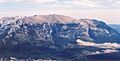
Grotto Mountain in 2005

