Fayston, Vermont facts for kids
Quick facts for kids
Fayston, Vermont
|
|
|---|---|
 |
|

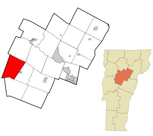
Location in Washington County and the state of Vermont
|
|
| Country | United States |
| State | Vermont |
| County | Washington |
| Communities |
|
| Area | |
| • Total | 36.5 sq mi (94.5 km2) |
| • Land | 36.5 sq mi (94.5 km2) |
| • Water | 0.0 sq mi (0.0 km2) |
| Elevation | 1,755 ft (535 m) |
| Population
(2020)
|
|
| • Total | 1,364 |
| • Density | 37.37/sq mi (14.434/km2) |
| Time zone | UTC-5 (Eastern (EST)) |
| • Summer (DST) | UTC-4 (EDT) |
| ZIP Codes | |
| Area code(s) | 802 |
| FIPS code | 50-25825 |
| GNIS feature ID | 1462096 |
Fayston is a small town in Washington County, Vermont, United States. It's known for its beautiful natural areas. In 2020, about 1,364 people lived there.
Contents
A Look Back: Fayston's History
Fayston was officially created in 1788. It was first sold to someone who wanted to develop the land. The town then became organized in 1805.
Early Days and Growth
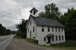
In its early years, Fayston was home to a small one-room schoolhouse. Many families were farmers or made maple syrup. These activities helped the town grow and become stable.
Mad River Glen Ski Area
A famous ski area called Mad River Glen was started in Fayston in 1947. It's located on Stark Mountain and is a popular spot for winter sports.
Exploring Fayston's Geography
Fayston covers about 36.5 square miles (which is about 94.5 square kilometers) of land. There are no large bodies of water within the town.
Location and Natural Features
The town is located in the Mad River valley. This valley is known for its scenic beauty. Fayston is also south of Camel's Hump State Park. A mountain called Burnt Rock Mountain is also found in Fayston. Vermont Route 17 is a main road that goes through the town.
Who Lives in Fayston: Population Facts
Fayston's population has changed a lot over the years. Here's how it has grown:
| Historical population | |||
|---|---|---|---|
| Census | Pop. | %± | |
| 1800 | 18 | — | |
| 1810 | 149 | 727.8% | |
| 1820 | 263 | 76.5% | |
| 1830 | 458 | 74.1% | |
| 1840 | 635 | 38.6% | |
| 1850 | 684 | 7.7% | |
| 1860 | 800 | 17.0% | |
| 1870 | 694 | −13.2% | |
| 1880 | 638 | −8.1% | |
| 1890 | 533 | −16.5% | |
| 1900 | 466 | −12.6% | |
| 1910 | 452 | −3.0% | |
| 1920 | 424 | −6.2% | |
| 1930 | 318 | −25.0% | |
| 1940 | 284 | −10.7% | |
| 1950 | 172 | −39.4% | |
| 1960 | 158 | −8.1% | |
| 1970 | 292 | 84.8% | |
| 1980 | 657 | 125.0% | |
| 1990 | 846 | 28.8% | |
| 2000 | 1,141 | 34.9% | |
| 2010 | 1,353 | 18.6% | |
| 2020 | 1,364 | 0.8% | |
| U.S. Decennial Census | |||
Population Details (2000 Census)
In 2000, there were 1,141 people living in Fayston. Most people were White. A small number of people were from other racial backgrounds.
There were 484 households in the town. Many of these households were married couples living together. About 30% of households had children under 18 living with them.
The average age of people in Fayston in 2000 was 39 years old. About 22.8% of the population was under 18.
Income Information (2000 Census)
In 2000, the average income for a household in Fayston was about $53,472 per year. For families, the average income was about $60,938. A small percentage of families and individuals lived below the poverty line.
See also
 In Spanish: Fayston para niños
 | Jackie Robinson |
 | Jack Johnson |
 | Althea Gibson |
 | Arthur Ashe |
 | Muhammad Ali |


