
Moretown, Vermont facts for kids
Quick facts for kids
Moretown, Vermont
|
|
|---|---|
 |
|

Location in Washington County and the state of Vermont
|
|

Moretown, Vermont
Location in the United States
|
|
| Country | United States |
| State | Vermont |
| County | Washington |
| Communities |
|
| Area | |
| • Total | 40.2 sq mi (104.2 km2) |
| • Land | 39.9 sq mi (103.3 km2) |
| • Water | 0.3 sq mi (0.8 km2) |
| Elevation | 1,083 ft (330 m) |
| Population
(2020)
|
|
| • Total | 1,753 |
| • Density | 43.57/sq mi (16.823/km2) |
| Time zone | UTC-5 (Eastern (EST)) |
| • Summer (DST) | UTC-4 (EDT) |
| ZIP Codes | |
| Area code(s) | 802 |
| FIPS code | 50-46225 |
| GNIS feature ID | 1462153 |
Moretown is a small town located in Washington County, Vermont, in the United States. In 2020, about 1,753 people lived there.
Contents
History of Moretown
In 2011, a big storm called Hurricane Irene caused a lot of damage in Moretown. Over 60 homes and buildings were flooded. This included important places like the post office, town offices, the church, the school, and the fire station.
A long time ago, in 1913, a company bought 125 acres of land in North Moretown. They built a factory there to process a mineral called talc. Today, that old factory building is still a landmark in the town, even though it is no longer used.
Moretown's Geography
Moretown covers a total area of about 104.2 square kilometers (40.2 square miles). Most of this area, about 103.3 square kilometers (39.9 square miles), is land. The rest, about 0.8 square kilometers (0.3 square miles), is water.
Population and People
| Historical population | |||
|---|---|---|---|
| Census | Pop. | %± | |
| 1800 | 191 | — | |
| 1810 | 405 | 112.0% | |
| 1820 | 593 | 46.4% | |
| 1830 | 816 | 37.6% | |
| 1840 | 1,128 | 38.2% | |
| 1850 | 1,335 | 18.4% | |
| 1860 | 1,410 | 5.6% | |
| 1870 | 1,263 | −10.4% | |
| 1880 | 1,180 | −6.6% | |
| 1890 | 956 | −19.0% | |
| 1900 | 902 | −5.6% | |
| 1910 | 686 | −23.9% | |
| 1920 | 930 | 35.6% | |
| 1930 | 889 | −4.4% | |
| 1940 | 675 | −24.1% | |
| 1950 | 883 | 30.8% | |
| 1960 | 788 | −10.8% | |
| 1970 | 904 | 14.7% | |
| 1980 | 1,221 | 35.1% | |
| 1990 | 1,415 | 15.9% | |
| 2000 | 1,653 | 16.8% | |
| 2010 | 1,658 | 0.3% | |
| 2020 | 1,753 | 5.7% | |
| U.S. Decennial Census | |||
In the year 2000, there were 1,653 people living in Moretown. These people lived in 650 different homes. The town had about 41 people per square mile.
Most of the people in Moretown were White (98.19%). A small number were Native American (0.12%) or Asian (0.79%). About 0.67% of the population was Hispanic or Latino.
Many homes (35.7%) had children under 18 living there. More than half (55.1%) were married couples. About 22.3% of homes had just one person living in them. The average home had about 2.54 people.
The age of people in Moretown varied. About 26.6% were under 18 years old. The median age, which is the middle age of all the people, was 38 years old.
Moretown's Economy
Moretown has one main store called The Moretown General Store. It's a gas station, a convenience store, and a deli all in one. This store is like the heart of the town. It's a common place for people to meet and gather.
Many people in Moretown are skilled workers. They work in jobs like real estate, carpentry, baking, and plumbing. However, most residents travel to bigger towns for work. They often go to places like Montpelier and Burlington.
Moretown also has a few small farms. There's a mill that makes clapboard (a type of wooden siding for houses). The town has three churches, one elementary school, a small library, and a town hall.
Famous People from Moretown
Some notable people have connections to Moretown:
- Matthew H. Carpenter was a US senator from Wisconsin.
- Harvey Clapp, who was a member of the Wisconsin State Assembly, was born in Moretown.
- William B. Mayo was a medical doctor and politician in Northfield, Vermont.
Images for kids
-
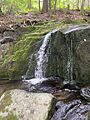
A creek near Moretown Common.
-
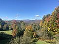
Camel's Hump viewed from Moretown in autumn.


See also
 In Spanish: Moretown para niños
