Florence Peak (California) facts for kids
Quick facts for kids Florence Peak |
|
|---|---|

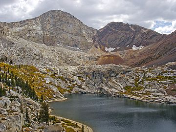
Florence Peak and Franklin Lake
|
|
| Highest point | |
| Elevation | 12,437 ft (3,791 m) NAVD 88 |
| Prominence | 1,033 ft (315 m) |
| Listing |
|
| Geography | |
| Parent range | Sierra Nevada |
| Topo map | USGS Mineral King |
| Climbing | |
| Easiest route | Simple scramble, class 2 |
Florence Peak is a tall mountain found in California, U.S.. It is part of the Great Western Divide, which is a smaller mountain range within the southern Sierra Nevada. This peak is special because it marks the southern border of Sequoia National Park. At its very top, three important wilderness areas meet: the Sequoia-Kings Canyon Wilderness, the John Krebs Wilderness, and the Golden Trout Wilderness.
Contents
All About Florence Peak
Where is Florence Peak?
Florence Peak is located in Tulare County, California. It stands about 6 miles (9.7 km) southeast of a small community called Silver City. It is also about 4.5 miles (7.2 km) from the end of the road at Mineral King.
How High is Florence Peak?
This mountain rises to an elevation of 12,438 feet (3,791 meters). This makes it one of the highest mountains in the area, especially south of Mount Whitney. Mount Whitney is the tallest mountain in the lower 48 U.S. states.
Water Around the Peak
The area around Florence Peak is very important for water. On the north side of the peak, you'll find the Franklin Lakes. These are a series of small lakes, called tarns, that sit in a bowl-shaped valley known as a cirque. Water from these lakes flows into the Kaweah River through Franklin Creek.
The eastern slopes of Florence Peak send their water into the Kern River. On the southwestern side, water drains into the Bullfrog Lakes, which are about 10,000 feet (3,000 meters) high. From there, the water flows into the Little Kern River.
Weather at the Summit
Because Florence Peak is so high, most of the moisture it receives falls as snow. This snow then melts and contributes to the rivers and lakes below.
 | Janet Taylor Pickett |
 | Synthia Saint James |
 | Howardena Pindell |
 | Faith Ringgold |


