Fords Prairie, Washington facts for kids
Quick facts for kids
Fords Prairie, Washington
|
|
|---|---|

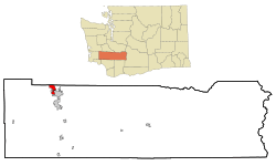
Location of Fords Prairie, Washington
|
|
| Country | United States |
| State | Washington |
| County | Lewis |
| Area | |
| • Total | 3.85 sq mi (9.98 km2) |
| • Land | 3.73 sq mi (9.65 km2) |
| • Water | 0.13 sq mi (0.33 km2) |
| Elevation | 177 ft (54 m) |
| Population
(2020)
|
|
| • Total | 2,234 |
| • Density | 526/sq mi (203.0/km2) |
| Time zone | UTC-8 (Pacific (PST)) |
| • Summer (DST) | UTC-7 (PDT) |
| ZIP code |
98531
|
| Area code(s) | 360 |
| FIPS code | 53-24565 |
| GNIS feature ID | 1504952 |
Fords Prairie is a small community in Lewis County, Washington, United States. It's a place where people live, but it's not officially a city. In 2020, about 2,234 people lived there.
Contents
History of Fords Prairie
Early Settlers and Naming
The area where Fords Prairie is located was first known as "Tasunshun." This name was given by the Upper Chehalis tribe, who were the original inhabitants.
Later, the area was named after Judge Sidney S. Ford, Sr. and his wife Nancy. They were among the first white pioneers to settle north of the Columbia River in 1846. At that time, this land was part of the Oregon Territory.
A Key Travel Stop
The Ford family claimed about 640 acres of land. This land was right next to the Chehalis River. Their property became the center of what everyone called Fords Prairie.
It was a very important stop for travelers. People journeying between the Columbia River and Puget Sound would often pass through Fords Prairie.
Geography of Fords Prairie
Location and Borders
Fords Prairie is located in Washington state. To its south, you'll find the city of Centralia. To the north, the community of Grand Mound in Thurston County borders it.
A major highway, Interstate 5, runs along the eastern edge of Fords Prairie. You can get to Fords Prairie from Exit 82 (Harrison Avenue) in Centralia.
Land and Water
Fords Prairie covers about 10 square kilometers (about 3.9 square miles). Most of this area is land, roughly 9.7 square kilometers (3.7 square miles). A small part, about 0.3 square kilometers (0.1 square miles), is water.
The community sits on the east side of the Chehalis River. This river flows northwest and eventually reaches the Pacific Ocean at Grays Harbor.
Population of Fords Prairie
| Historical population | |||
|---|---|---|---|
| Census | Pop. | %± | |
| 1960 | 1,404 | — | |
| 1970 | 2,250 | 60.3% | |
| 1980 | 2,582 | 14.8% | |
| 1990 | 2,480 | −4.0% | |
| 2000 | 1,961 | −20.9% | |
| 2010 | 1,959 | −0.1% | |
| 2020 | 2,234 | 14.0% | |
| U.S. Decennial Census 2020 Census |
|||
Fords Prairie has seen its population change over the years. In 2000, there were 1,961 people living there. By 2020, the population had grown to 2,234 people.
Parks and Recreation in Fords Prairie
Local Parks and Trails
There are fun places to visit near Fords Prairie. The Fort Borst Park complex is located just south of the area. This park includes the historic Borst Home and a dog park called Pioneer Park Dog Park.
Another great spot is the Discovery Trail. This trail opened in 2006. It winds through the natural area next to the Chehalis River, offering a nice place for walks and enjoying nature.
See also
 In Spanish: Fords Prairie (Washington) para niños

