Prospect Bluff Historic Sites facts for kids
|
British Fort
|
|
 |
|
| Location | Franklin County, Florida |
|---|---|
| Nearest city | Sumatra |
| Area | 7 acres (2.8 ha) |
| Built | 1814 |
| NRHP reference No. | 72000318 |
Quick facts for kids Significant dates |
|
| Added to NRHP | February 23, 1972 |
| Designated NHL | February 23, 1972 |

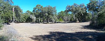
The Prospect Bluff Historic Sites are located in Franklin County, Florida. This important historical place is found on the Apalachicola River, about 6 miles (10 km) southwest of Sumatra, Florida. At this site, you can find the remains of two old forts.
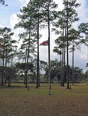
The first and larger fort was built by the British in 1814 during the War of 1812. After the British left Florida in 1815, they allowed former enslaved people and Creek Native Americans to live there. The British purposely left their weapons behind for them. Since the British had not named it, Americans started calling it the Negro Fort. U.S. forces destroyed it in a river attack in 1816.
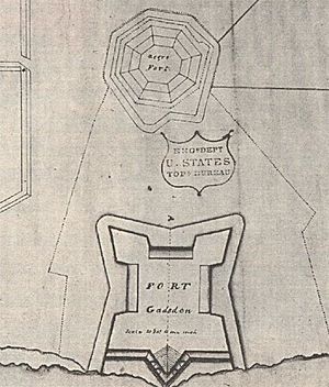
Later, in 1818, a new fort called Fort Gadsden was built inside the old walls of the Negro Fort.
Over time, this site has been known by many names. These include Prospect Bluff, British post, Nicholls' Fort, Blount's Fort, African Fort, and Fort Apalachicola. The local Native Americans called the land Achackwheithle.
The Prospect Bluff Historic Sites were added to the National Register of Historic Places and named a National Historic Landmark in 1972. The Apalachicola National Forest took over the site in 1940. Today, the U.S. Forest Service manages it. The site has signs that explain its history, a picnic area with a shelter, and rest rooms.
Contents
Why Prospect Bluff Was Important
The area where both the Negro Fort and Fort Gadsden were built is called Prospect Bluff. It was a good spot because it was a "fine bluff overlooking the Apalachicola River." This small hill, only about 12 feet (3.7 m) high, was almost surrounded by a swamp. This made it a naturally strong place for a fort. The name "Prospect Bluff" is similar to the Spanish name, Loma de Buena Vista, which means "hill with a good view."
Back then, you could only reach the site by river. It was, and still is, a remote area. The river was the border between East Florida and West Florida when the British (1763–1783) and Spanish (1783–1821) controlled Florida. Today, it is about 198 miles (319 km) from Pensacola and 271 miles (436 km) from St. Augustine by land. Much of the area later became the Apalachicola National Forest.
The British were very interested in the river. They saw it as an easy way to enter the United States through Georgia. Spain, however, was not very interested in the river. Spain had limited forces in Florida and was more focused on its other colonies. Spain's inability to control its borders and stop enslaved people from escaping was a big reason why Florida was given to the United States in 1821.
Controlling Prospect Bluff meant controlling the river. The river had been a major transportation route for hundreds of years. It allowed groups to travel upriver into Georgia and the Mississippi Territory. They could reach plantations by using the Chattahoochee and especially the Flint River. These groups would attack plantations, which often had few defenses. Besides taking goods, they helped enslaved people on the plantations gain their freedom. This caused big financial losses for slave owners. It also made them feel unsafe and angry.
Prospect Bluff was also important militarily because it was at a "strategic location." It was on a bend in the river, which gave a great view and advantage over any boats coming by.
Before the Forts (Before 1814)
Before 1814, the Florida panhandle was mostly wild land. Many Native American refugees from the United States lived there. They joined together to form a new group called the Seminoles. This area was also a great hiding place for escaped enslaved people. They got along well with the Seminoles because they shared a common enemy. Over time, a strong connection grew between escaped Africans and the Seminoles. The former enslaved people often knew English and helped as interpreters. This was like an early version of the Underground Railroad, but it went south.
The main concern for white settlers was how to get escaped enslaved people back. They also wanted to prevent future escapes. Native Americans were later forced to leave Florida as well.
In the past, before railroads, people settled mostly along rivers. The Apalachicola River gets its name from the Apalachicola Province. This area is now on the Chattahoochee River. Records show that maroons (escaped enslaved people and their families), Seminoles, and some Europeans settled at Prospect Bluff in the late 1700s.
In 1783, a meeting was held in St. Augustine. British leaders met with the chiefs of the Upper and Lower Creeks. The Native Americans complained that they had to travel too far to get supplies. They suggested the Apalachicola River as a good place for a trading post. They asked for Panton, Leslie & Company, who supplied them with goods, to set up a store there.
William Panton agreed to open a store between the Flint River and the Apalachicola River. This store opened in 1784. By then, Spain had taken control of Florida again. The store was at Fort San Marcos de Apalache (modern St. Marks, Florida). An adventurer named William Augustus Bowles attacked and robbed this store in 1792 and again in 1800, after which it closed.
In 1804, a new trading post was set up at Prospect Bluff. This was done by John Forbes and Company, who took over from Panton, Leslie & Company. The "Indians" (specifically Mickosuckees) asked for it to be at the more defensible Prospect Bluff. Edmund Doyle ran the post with help from William Hambly. The trading post was inside the walls of the fort that was built around it. It had a building for storing animal hides, living quarters for enslaved people, and a pen for hundreds of cattle. During the War of 1812, British troops raided the store and freed the enslaved people.
Between 300 and 1,000 maroons settled in the area around Prospect Bluff. These free black communities developed farms that stretched up to 50 miles (80 km) along the river. A report from 1812 mentioned over 36 acres (15 ha) of cleared land and 1,200 cattle. They lived in "large and well-built cabins" and grew crops like peas, beans, corn, and rice.
The British Post (1814–1815)
The British started building the fort in May 1814. They had taken over the trading post of John Forbes and Company.
During the War of 1812, the British invaded Pensacola. They stayed there until General Andrew Jackson captured the town on November 7, 1814. British forces, led by Captain George Woodbine, then set up camp at the trading post of John Forbes and Company. This post was surrounded by farms run by free black people.
Woodbine began training local Native Americans and escaped enslaved people. Nicolls recruited the former enslaved people into a new black military group called the Corps of Colonial Marines. These soldiers were well-armed and well-trained. Nicolls also trained over 500 Creek and Seminole Native Americans by February 1815. However, he found the former enslaved people to be better soldiers. He reported that his black recruits were very disciplined, saying that "out of 1,500 of them I never had occasion to punish one of them."
The British were planning to attack Georgia when they heard the war had ended. The British paid the Colonial Marines the same as white Marines and left Florida. On May 16, 1815, the last British soldiers left the fort.
Blacks and Native Americans, guided by Nicolls, built two forts on the Apalachicola River. The larger and more important one was meant to be a supply base for another fort closer to the Georgia border. This larger fort was simply called the British Post. It was 15 miles (24 km) upriver from the river's mouth. The fort was very well supplied with weapons and military equipment.
The fort covered about 7 acres (2.8 ha). Its eastern corners, which were most likely to be attacked, had strong walls called bastions. These walls were 15 feet (4.6 m) high and 18 feet (5.5 m) thick.
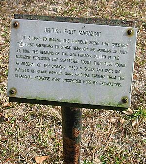
The fort's main powder magazine was inside an octagonal blockhouse. This was about 500 feet (150 m) from the river. The blockhouse was surrounded by a large, star-shaped area covering about 16 acres (6.5 ha).
It was estimated that 900 Native American warriors and 450 armed black people lived at the fort.
The Negro Fort (1815–1816)
When the British left, they purposely left all their weapons behind. They hoped the local people would use them to defend themselves from U.S. attempts to re-enslave them. Most of the Native American warriors (Seminoles and Red Stick Creeks) left the fort soon after.
However, many of the trained soldiers from the Corps of Colonial Marines, a British Army group made of freed enslaved people, stayed.
Over the next year, the fort became a growing community for escaped enslaved people from Georgia and the Mississippi Territory. It became known as the Negro Fort. It was the largest community of free black people in North America before the U.S. Civil War.
The U.S. government saw the fort as a danger. It was "a beacon of light to restless and rebellious slaves" and "a center of hostility." It was also a threat to the safety of enslaved people in nearby areas. On April 8, 1816, General Jackson ordered General Gaines to "take care of the situation." Jackson believed the fort should be "blown up" because it was causing "rapine and plunder." He wanted the "stolen Negros and plunder" returned to their owners.
Jackson insisted that the "Negroes now in the said fort" who had been "stolen and enticed" from U.S. citizens and friendly Native Americans be returned. He stated that if Spanish authorities did not stop this, the U.S. would have to destroy the fort for self-defense.
After Spain's governor replied that he could not act without orders from his superior, Jackson went ahead with his plan to destroy the fort.
The first step was building Fort Scott upriver in Georgia. Boats supplying Fort Scott had to pass the Negro Fort. These supply boats were protected by two gunboats. Gaines wanted to provoke an attack to justify destroying the fort. When shots were fired from the fort at passing boats, Gaines had the excuse he needed. On July 27, 1816, a "hot shot" (a cannonball heated until it glowed red) from an American gunboat hit the fort's powder magazine. This caused a huge explosion that could be heard over 100 miles (160 km) away in Pensacola. The explosion destroyed the fort, killing all but 30 of its 300 occupants. It is known as "the single deadliest cannon shot in American history." It was also "the largest battle in history between fugitive slaves and U.S. forces seeking to reenslave them."
Spain protested that the U.S. had invaded its land. However, Spain was not strong enough to do more.
After the fort was destroyed, the trading post of John Forbes and Company, run by Edward Doyle, was set up again.
Fort Gadsden (1818–1821)
To control the important Prospect Bluff area, protect trade on the river, and prevent new communities of escaped enslaved people from forming, General Jackson ordered a new fort. In 1818, he told Lieutenant James Gadsden of the Army Corps of Engineers to rebuild the fort. Gadsden built the new fort, which was much smaller, within the old earthworks of the Negro Fort. Jackson named this new fort Fort Gadsden.
However, an aide to General Andrew Jackson reported in August 1818 that Fort Gadsden was "a temporary work, hastily erected." He said it was made of materials that would not last long. He believed it would only last "four or five years" without constant repairs. The fort was abandoned in 1821. This was the year Florida became a U.S. territory, so there was no longer a national border to defend.
Fort Gadsden was not directly involved in any military battles, either from 1818–1821 or during the Civil War.
Colinton: A City That Never Was
In 1820, Colin Mitchell bought the Forbes Lands, which included Fort Gadsden. The next year, he planned to build a city called Colinton at the site. The city was supposed to have four squares and docks for steamboats. However, Mitchell's claim to the land was found to be invalid, so Colinton was never built.
"Milly Francis"
A marker at the site remembers Milly Francis. She was a Creek girl who convinced her father, Hillis Hadjo (Francis the Prophet), not to kill an American soldier who had accidentally entered their land. Her father was later captured and hanged at Fort St. Marks in 1818. She saw him being hanged.
Irvington Steamboat Remains
A steamboat called the Irvington caught fire and sank in 1838. This happened four miles (6.4 km) north of the site. The rusty boilers and some other parts believed to be from this ship were pulled from the river. You can see these parts at the site today.
Civil War (1862–1863)
During the American Civil War, soldiers from the Confederate side used the fort. They used it to protect communication routes for farms in Georgia, Florida, and Alabama that sent goods to the port of Apalachicola. In July 1863, many soldiers got malaria, a serious illness. This forced them to leave the fort.
Why the Site's Name Changed
For a long time, the history of the former enslaved people at Prospect Bluff was not widely known. The most important time in Prospect Bluff's history is probably the Negro Fort period (1815–1816). This is the period that is highlighted in the National Register Nomination. However, the site was first named Fort Gadsden Historic Site in 1961. This was a less historically important fort. At that time, racial issues might have led to downplaying the battle.
In 2016, the site was renamed Prospect Bluff Historic Sites. This new name recognizes that more than just Fort Gadsden existed there. It also uses a name that people living in the area in the 1800s would have known.
Recent Activities
- From May 16–20, 2016, the National Park Service held a workshop. Fifty people learned how to use technology to study what is under the ground without digging.
- On October 22, 2016, the United States Forest Service marked 200 years since the events of July 1816. There was a Seminole Color Guard and "descendants of Prospect Bluff Maroon community." The main speaker was Chairman James E. Billie of the Seminole Tribe of Florida. A video of the ceremony is available online.
- The Florida Humanities Council helped fund a project that created virtual landscapes of Prospect Bluff in 1816. They also created a virtual landscape of the Maroon community of Angola on the Manatee River.
See also
In Spanish: Fuerte Gadsden para niños
 | May Edward Chinn |
 | Rebecca Cole |
 | Alexa Canady |
 | Dorothy Lavinia Brown |


