Fort Macleod facts for kids
Quick facts for kids
Fort Macleod
Macleod (1884–1952)
|
|
|---|---|
|
Town
|
|
| Town of Fort Macleod | |

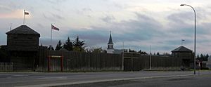
The NWMP fort in Fort Macleod, which is now a museum
|
|
| Country | Canada |
| Province | Alberta |
| Region | Southern Alberta |
| Census division | 3 |
| Municipal district | Municipal District of Willow Creek No. 26 |
| Incorporated | |
| • Town | December 31, 1892 (as Macleod) |
| • Name change | April 1, 1952 |
| Area
(2021)
|
|
| • Land | 22.54 km2 (8.70 sq mi) |
| Elevation | 945 m (3,100 ft) |
| Population
(2021)
|
|
| • Total | 3,297 |
| • Density | 146.2/km2 (379/sq mi) |
| Time zone | UTC−7 (MST) |
| • Summer (DST) | UTC−6 (MDT) |
| Postal code span |
T0L
|
| Area code(s) | +1-403 |
Fort Macleod (/məˈklaʊd/ MƏ-klowd) is a town in southern Alberta, Canada. It was first called Macleod. This name helped tell it apart from the North-West Mounted Police (NWMP) fort built there in 1874. The fort was named after Colonel James Macleod, who was a leader of the NWMP.
The town officially became "Fort Macleod" in 1952. But people had been calling it that for a long time. Today, it's a place with a rich history, especially linked to the early days of policing in Canada.
Contents
History of Fort Macleod
The original fort was built on October 18, 1874. It was a square, about 70 by 70 meters. The fort had living areas for men and Mounties. It also had important buildings like hospitals and stores. Stables and a blacksmith's shop were at the north end.
The town grew around this fort. Fort Macleod became the second main base for the North-West Mounted Police (NWMP). The first base, Fort Livingstone, was left in 1876. The fort was first on a small piece of land by the Oldman River. In 1884, it moved to where the town is now. You can visit the Museum of the North-West Mounted Police in Fort Macleod today.
Growth and Challenges
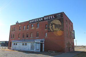
When farming and the railway came to the area, Fort Macleod grew quickly. The town became a major stop for the Canadian Pacific Railway. Old wooden buildings were replaced with new ones made of brick and sandstone.
In 1906, a big fire destroyed many wooden buildings downtown. But the town rebuilt, and from 1906 to 1912, it saw its biggest growth. More brick and stone buildings went up. However, in 1912, the railway moved its main operations and 200 jobs to Lethbridge. This hurt Fort Macleod's economy badly. The town stopped growing and even went bankrupt in 1924.
Preserving History
For many years, the town's economy didn't change much. This meant that many of its old buildings from the early 1900s stayed just as they were. In 1978, the government of Alberta started looking at the historic buildings downtown.
In 1982, the downtown area became Alberta's first "Provincial Historic Area." This means it's a special place protected for its history. Also in 1982, a project began to help restore the old sandstone and brick buildings. Some of these buildings date back to 1878.
Population of Fort Macleod
In 2021, the town of Fort Macleod had a population of 3,297 people. These residents lived in 1,342 homes. This number was a bit higher than its population in 2016, which was 2,967 people. The town covers a land area of about 22.54 square kilometers. This means there were about 146 people living in each square kilometer in 2021.
Fort Macleod's Location
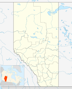
Fort Macleod is in the Municipal District of Willow Creek No. 26. It's located where two main roads, Highway 2 and Highway 3, meet. The town is also right on the Oldman River.
It is west of the larger city of Lethbridge. Nearby are the lands of the Peigan and Kainai First Nations. The beautiful Waterton Lakes National Park is also close by. About 8 kilometers north of town is the McBride Lake Wind Farm. This is one of Alberta's largest wind farms, making 75 megawatts of electricity.
Weather in Fort Macleod
Fort Macleod has a type of weather called a humid continental climate. This means it has warm summers and cold winters.
Chinook Winds
In winter, the town often gets a break from the cold thanks to the Chinook wind. This warm, dry wind blows down from the Rocky Mountains. For example, on February 27, 1992, a Chinook caused the temperature to rise to a warm 26.5 degrees Celsius!
Temperature Records
The hottest temperature ever recorded in Fort Macleod was 38.9 degrees Celsius. This happened on July 7, 1896, July 18, 1910, and July 17, 1919. The coldest temperature ever recorded was a very chilly -45.0 degrees Celsius. This was on February 2, 1905, December 17, 1924, and January 28, 1929.
| Climate data for Fort Macleod, 1971–2000 normals, extremes 1876–present | |||||||||||||
|---|---|---|---|---|---|---|---|---|---|---|---|---|---|
| Month | Jan | Feb | Mar | Apr | May | Jun | Jul | Aug | Sep | Oct | Nov | Dec | Year |
| Record high °C (°F) | 19.8 (67.6) |
26.5 (79.7) |
27.8 (82.0) |
32.2 (90.0) |
34.5 (94.1) |
38.3 (100.9) |
38.9 (102.0) |
37.2 (99.0) |
36.7 (98.1) |
31.0 (87.8) |
26.1 (79.0) |
25.0 (77.0) |
38.9 (102.0) |
| Mean daily maximum °C (°F) | −1.3 (29.7) |
1.9 (35.4) |
6.7 (44.1) |
12.7 (54.9) |
18.0 (64.4) |
22.4 (72.3) |
25.6 (78.1) |
24.8 (76.6) |
19.1 (66.4) |
14.3 (57.7) |
4.2 (39.6) |
−0.2 (31.6) |
12.4 (54.3) |
| Daily mean °C (°F) | −7.1 (19.2) |
−4.3 (24.3) |
0.4 (32.7) |
6.0 (42.8) |
11.1 (52.0) |
15.4 (59.7) |
18.0 (64.4) |
17.2 (63.0) |
11.8 (53.2) |
7.2 (45.0) |
−1.2 (29.8) |
−5.8 (21.6) |
5.7 (42.3) |
| Mean daily minimum °C (°F) | −13 (9) |
−10.4 (13.3) |
−5.9 (21.4) |
−0.8 (30.6) |
4.1 (39.4) |
8.3 (46.9) |
10.4 (50.7) |
9.5 (49.1) |
4.4 (39.9) |
0.0 (32.0) |
−6.7 (19.9) |
−11.5 (11.3) |
−1 (30) |
| Record low °C (°F) | −45 (−49) |
−45 (−49) |
−36.7 (−34.1) |
−23.3 (−9.9) |
−15 (5) |
−10 (14) |
0.0 (32.0) |
−2.2 (28.0) |
−17.8 (0.0) |
−28 (−18) |
−38.9 (−38.0) |
−45 (−49) |
−45 (−49) |
| Average precipitation mm (inches) | 21.0 (0.83) |
17.8 (0.70) |
27.5 (1.08) |
37.7 (1.48) |
57.2 (2.25) |
61.2 (2.41) |
46.5 (1.83) |
50.0 (1.97) |
46.2 (1.82) |
18.9 (0.74) |
20.2 (0.80) |
20.9 (0.82) |
425.0 (16.73) |
| Source: Environment Canada | |||||||||||||
Sports and Recreation
Fort Macleod has its own Senior AA men's hockey team. They are called the Fort Macleod Mustangs. They play in the Ranchland Hockey League.
Local News and Media
The town of Fort Macleod has a local weekly newspaper. It is called the Fort Macleod Gazette.
Past Newspapers
Over the years, Fort Macleod has had several other newspapers. These include:
- Macleod Advertiser (1909–1913)
- Macleod Chronicle (around 1908–1909)
- Macleod Gazette (early issues were called The Macleod Gazette and Alberta Stock Record)
- Macleod News (1916–1919)
- Macleod Spectator (1912–1916)
Famous People from Fort Macleod
Many interesting people have connections to Fort Macleod. Some of them include:
- Henrietta Muir Edwards (1849–1931), a famous activist for women's rights.
- Frederick Maurice Watson Harvey (1888–1980), an Irish-Canadian soldier and rugby player.
- Sir Frederick Haultain (1857–1942), a former leader of the North-West Territories.
- Joni Mitchell (born 1943), a world-famous musician.
- Ryland Moranz (born 1986), another talented musician.
- Constantine Scollen (1841–1902), a missionary.
- John Wort Hannam (born 1968), a musician.
Fort Macleod in Movies and TV
Fort Macleod's historic downtown has been a popular spot for filming movies and TV shows. Its old buildings give it a unique look.
Filming Locations
- The romantic drama film Brokeback Mountain (2005) was partly filmed here. You can even find a sign marking a scene from the movie at 2422 Third Avenue.
- The movie Passchendaele also used Fort Macleod's downtown. It stood in for Calgary in 1915.
- In Christopher Nolan's 2014 film Interstellar, scenes with dust storms and Matthew McConaughey's character were filmed in Fort Macleod. Huge fans created the dust clouds on location.
- Badland, a drama by Francesco Lucente, was mostly filmed in Fort Macleod. Lucente lived in the town for several years.
- The downtown historic buildings were also used in the 2021 film Ghostbusters: Afterlife.
- The popular 2023 TV series The Last of Us also used Fort Macleod as a filming location.


