
History of the Northwest Territories facts for kids
The history of the Northwest Territories tells the story of this large Canadian region, from thousands of years ago to today. For a very long time, before Europeans arrived, many First Nations and Inuit peoples lived on these lands.
European explorers and fur traders started exploring the area in the late 1500s. By the 1600s, the British claimed a huge area, including what they called the North-Western Territory and Rupert's Land. They gave the Hudson's Bay Company the sole right to trade furs in Rupert's Land.
On June 23, 1870, the United Kingdom officially gave the North-Western Territory and Rupert's Land to the government of Canada. Most of this new land became known as the North-West Territories. The hyphen was later removed in 1906. In 1880, the territory became its largest when the British Arctic Territories were added. However, its size was reduced many times. For example, Yukon Territory was created from its western parts in 1898. In 1905, Alberta and Saskatchewan became provinces from its southwestern parts. In 1912, lands south of the 60th parallel north and the District of Ungava were given to Manitoba, Ontario, and Quebec.
During the Cold War, more power was given from the Canadian government to the territory. The capital moved from Ottawa to Yellowknife in 1967. In the 1900s, the Canadian government talked with the Inuit Tapiriit Kanatami about land claims. These talks led to the eastern part of the territory becoming the new territory of Nunavut in 1999.
Contents
Early History of the Northwest Territories

Long before Europeans arrived, the lands of the Northwest Territories were home to many Inuit and First Nations peoples. Some Inuit groups included the Mackenzie, Copper, Caribou, and Central nations. When the first Europeans came, there were also many First Nations groups. These included the Yellowknives, Chipewyan, Sekani, Beaver, Nahanni, Dogrib, and Slavey peoples.
Martin Frobisher's trips in the 1570s were the first times a European visited the Northwest Territories that we know about. In 1610, Henry Hudson was looking for the Northwest Passage. He briefly landed on the western shore of the bay named after him. His discovery opened up the middle of the continent for more exploration. Other early explorers included Luke Foxe, John Davis, Robert Bylot, Thomas Button, George Weymouth, Thomas James, and William Baffin.
Fur Trade (1600s and 1700s)
In 1670, King Charles II gave a special paper to the Hudson's Bay Company (HBC). This paper gave them control over the lands where rivers flowed into Hudson's Bay.
By the 1700s, two main companies controlled the fur trade in the North-West Territories. These were the Hudson's Bay Company, based in London, England, and the North West Company, based in Montréal. Fur trade explorer Peter Pond found a route through the Methye Portage. This led into the huge northern territory where rivers flowed north instead of east.
In 1771, Samuel Hearne was the first European to reach the Arctic Ocean by traveling over land. He followed the Coppermine River. Further west, in 1789, Alexander Mackenzie also reached the Arctic Ocean. The river he used to get there is now called the Mackenzie River.
.jpg)
York Factory later became the main base for the Hudson's Bay Company. The HBC relied on furs coming to York Factory. The North West Company competed by traveling through the territory and collecting furs themselves. Some of these traders wrote journals, which were later published. This made people more interested in the northern lands.
As more Europeans arrived, they worked with First Nations peoples. First Nations acted as guides and supplied furs. The Chipewyan people became middlemen. They brought furs from western tribes to York Factory. The Cree, Chipewyan, Beaver, and Yellowknives got firearms. With this new advantage, they became stronger than their Athapaskan neighbours, like the Slavey, Sekani, and Dogrib peoples.
1800–1870: Changes and Discoveries
Around 1810, the North West Company set up a trading post at Tulita (Fort Norman). This was where the Mackenzie and Great Bear Rivers meet. The location of the post changed a few times, but the community of Tulita is still there today.
In 1821, the North West Company and the Hudson's Bay Company joined together. They kept the name Hudson's Bay Company. By 1825, Sir George Simpson became the head of this new company. Simpson traveled all over the north-west. For 40 years, he led the company. During most of that time, he made at least one big journey by canoe every year.
Arctic Exploration Expeditions

John Franklin's Coppermine expedition from 1819 to 1822 aimed to explore the northern coast of Canada. They reached it by following the Coppermine River. The British navy organized this trip. It was part of their effort to find and map the Northwest Passage. This was the first of three Arctic trips led by John Franklin. George Back and John Richardson were also on this trip. They later became important Arctic explorers themselves.
In 1825, Franklin started his second trip to the Canadian North. He traveled to the mouth of the Mackenzie River. Then he spent the winter at Fort Franklin, now called Deline, on Great Bear Lake.
Franklin's last trip, the third expedition, began in 1845. No one ever heard from them again. A huge search followed. At first, they found little trace of the expedition. But the search helped map much of the Arctic coastline. It was later learned that Franklin died in 1847. The remains of his two ships were finally found in 2014 and 2016.
George Back, a British naval officer, scientist, and artist, worked with John Franklin on his first Arctic trip in 1818. On Franklin's Coppermine trip (1819–1822), Back was in charge of all the surveying and map-making. Then, on the Mackenzie River trip (1824–1826), Back was promoted to lieutenant and then to commander.
Canadian Confederation and the Late 1800s

After the Deed of Surrender was passed, the United Kingdom gave Rupert's Land and the North-Western Territory from the Hudson's Bay Company to the government of Canada. However, adding these lands to Canadian Confederation was delayed by the Red River Rebellion. This rebellion happened around the Red River Colony. Eventually, the territories joined Canada on July 15, 1870, as the North-West Territories. The area around the Red River Colony became the province of Manitoba.
In 1880, the British Arctic Territories were also transferred from the United Kingdom to Canada. They became part of the North-West Territories.
Late 1800s Changes
The first government of the North-West Territories started in 1872. The Temporary North-West Council was appointed. The first time the North-West Territories government met inside the territories was at Fort Livingstone in 1876. This place is now in Saskatchewan. The government moved to Battleford in 1878. The first election for the territory happened in 1881. French was no longer an official language in 1892.
During the late 1800s, the borders of the territories changed many times. In 1886, the southwestern border of the District of Keewatin was adjusted. In 1889, a disputed area between Manitoba and Ontario was mostly given to Ontario. Some went to the District of Keewatin, and Manitoba got none. In 1898, after the Klondike Gold Rush, the Yukon was no longer part of the North-West Territories. A separate Yukon Territory was created from the western North-West Territories.
Treaty No. 8

In June 1899, talks began for Treaty No. 8. This treaty covered a huge area of 840,000 square kilometers in the North-West Territories. It was an agreement between the Canadian Government and the Dene groups in that area. In exchange for sharing their land with non-Natives, the Dene would receive help with health and education. They would also get treaty payments.
The Canadian Government and various Dene groups, including Yellowknives and Tłįchǫ under Chief Drygeese, signed the treaty in 1900 at Fort Resolution. After signing, the group that signed the treaty was called the "Yellowknife B Band." At that time, Treaty No. 8 was the largest land agreement the Canadian Government had ever made.
20th Century History
In 1901, the borders of Yukon Territory changed again, gaining land from the North-West Territories. Alberta and Saskatchewan became separate provinces from the territories in 1905. Even though the District of Keewatin was given back to the territories, the population dropped a lot. It went from about 160,000 to 17,000 people. Out of these, 16,000 were Indigenous people who could not vote under Canadian law. The government of the North-West Territories went back to being controlled by the federal government from Ottawa.

In 1906, the official name dropped the hyphen, becoming "Northwest Territories." On May 15, 1912, parts of the Northwest Territories were given to Manitoba, Ontario, and Quebec.
Between the World Wars (1918–1939)
Twenty years after Treaty No. 8 was signed, oil was found in the Mackenzie River Valley. After this discovery, the Canadian Government suggested another treaty. This new treaty would make it easier for miners and developers to work in the area. The treaty was debated a lot. Indigenous peoples did not want to lose their right to hunt, fish, gather, and trap in the area. They also did not want to be "confined to Indian reserves." Many Dene felt that Treaty No. 8 had not been honored by the Canadian Government. Some were afraid this new treaty would be similar.
However, Treaty No. 11 was signed by the Tłı̨chǫ trading chief Monfwi in the summer of 1921. The Tłı̨chǫ groups who signed this treaty were then known as the "Dog Rib Rae Band." Both Treaty No. 8 and Treaty No. 11 cover some of the same areas. This continues to cause disagreements between the two different treaty groups (now called First Nations).
In 1925, Canada became the first country to extend its ocean borders northward to the North Pole. This was based on something called the Sector Principle. The Northwest Territories grew to 3.3 million square kilometers. This was about one-third of Canada's total land area.
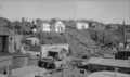
In the summer of 1935, almost 1000 men in 188 surveying teams searched a large part of Canada for valuable minerals. The most important discovery was made in the Yellowknife district. Nearly 3,000 square miles of good gold prospecting land were found. This led to the creation of the town of Yellowknife. Thirty-two years later, when the Government of the Northwest Territories moved north from Ottawa, Yellowknife became the new capital.
World War II (1939–1945)

During World War II, a Canadian company called Eldorado Mining and Refining produced uranium. This uranium was a byproduct of gold and radium production from its mine at Port Radium in the Northwest Territories. The Canadian government asked this company to help get uranium for the Manhattan Project. This was a secret project to build the first atomic bombs. The uranium ores were shipped from the Eldorado Mine to Port Hope, Ontario, to be processed.
Between 1942 and 1946, 40,000 American military and civilian workers came to the Canadian north-west. They were invited by the Canadian government. Plans included building the Alaska Highway to connect Edmonton, Alberta, with Fairbanks, Alaska. There were also plans for a pipeline to carry oil from the oil fields of Norman Wells to the Pacific Coast. Major construction began. The north-west's infrastructure, like roads and buildings, developed quickly. The presence of 40,000 military people greatly affected life throughout the region.
Early Cold War Era (1945–1970)
.jpg)
Elections returned in 1951. However, the Councils and Assemblies were not fully elected. They had a mix of elected and appointed members.
From 1953 to 1955, during the Cold War, Canada moved some Inuit families to the far north in the High Arctic relocation. This was partly to show that Canada owned these northern lands.
In 1967, the Minister of Indian Affairs and Northern Development, Arthur Laing, announced that Yellowknife would be the capital of the Northwest Territories. On September 18, 1967, the Government of the Northwest Territories moved from Ottawa to Yellowknife. Commissioner Stuart Milton Hodgson and 81 government employees arrived in Yellowknife on a special plane.
In 1969, a special committee of the Legislative Assembly of the Northwest Territories chose a new flag for the territory. Robert Bessant's design was picked from a Canada-wide contest. The government also introduced the popular polar bear license plate in 1970.
Late 20th Century (1971–2000)

In 1975, the territorial government became a fully elected body again. In 1984, the Canadian Government agreed to let the territories be in charge of naming places. This power had already been given to the provinces in 1961, but not to Canadian territories until then.
In April 1982, most residents of the Northwest Territories voted to divide the area. The federal government agreed to this seven months later, with some conditions. After many land claim talks between the Inuit Tapirisat of Canada and the federal government (which started in 1976), an agreement was reached in September 1992. In June 1993, the Nunavut Land Claims Agreement Act and the Nunavut Act were passed by the Canadian Parliament. The change to the new territory of Nunavut was completed on April 1, 1999.
21st Century
In the summer of 2023, the territory faced about 230 wildfires. This caused huge problems. About 70% of the territory's population had to leave their homes. Many went to other parts of Canada. This included 87% of the people in Yellowknife, including Premier Caroline Cochrane, as the fires came very close to the capital.
See also
- Commissioner of the Northwest Territories
- List of premiers of the Northwest Territories
- William Bompas
- List of communities in the Northwest Territories
- Districts of the Northwest Territories
- Canadian canoe routes
- List of lakes in the Northwest Territories
- List of rivers of the Northwest Territories
- List of Northwest Territories highways
- List of mines in the Northwest Territories
- Geographical Names Board of Canada
- List of schools in the Northwest Territories
- List of school districts in the Northwest Territories
- List of Northwest Territories Legislative Assemblies
- List of Northwest Territories general elections
- Sahtu Dene and Metis Comprehensive Land Claim Agreement
- Territorial claims in the Arctic
- Carrothers Commission
- Bible translations into Cree
- Symbols of the Northwest Territories
Images for kids
-
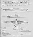
Illustration of canoe building at McArthur Lake from Samuel Hearne
-
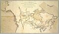
A map showing the route taken by Alexander MacKenzie from Montreal to Fort Chipewyan, and then to the Arctic Ocean.
-
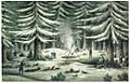
John Franklin's men building a camp during the first winter of their trip to the Coppermine River, around 1820.
-
Map showing Canada in 1870. Rupert's Land and the North-Western Territory are shaded. These two territories were given by the UK to Canada in 1870. Most of this land became the North-West Territories.
-
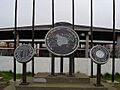
Markers celebrating the Treaty 8 site at Fort Resolution.
-
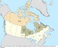
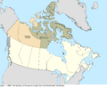
In 1912, the southeastern parts of the Northwest Territories were given to different provinces. After this, the territory stayed the same size from 1912 to 1999.
-
The Eldorado Mine, 1944. The Canadian government took control of it in 1939. It produced uranium for the Manhattan Project.
-
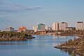
A view of Yellowknife in 2014. The city was chosen as the territory's new capital in 1967.
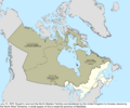
-
Map of Canada in 1999. The shaded area of the map was separated from the Northwest Territories in 1999 to form the new territory of Nunavut.
