
Fortress of Louisbourg facts for kids
Quick facts for kids Fortress of Louisbourg |
|
|---|---|
| Native name French: Forteresse de Louisbourg |
|

Diorama of the Fortress of Louisbourg in 1758
|
|
| Location | 259 Park Service Rd, Louisbourg, Nova Scotia, Canada B1C 2L2 |
| Built | 1713–1740 |
| Lua error in Module:Location_map at line 420: attempt to index field 'wikibase' (a nil value). | |
| Official name: Fortress of Louisbourg National Historic Site | |
| Designated: | 30 January 1920 |
The Fortress of Louisbourg (French: Forteresse de Louisbourg) is a cool place to visit in Nova Scotia, Canada. It's a National Historic Site that shows what an 18th-century French fortress looked like. About a quarter of the original fortress has been rebuilt!
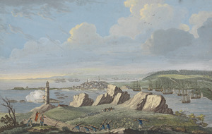
This fortress is located in Louisbourg on Cape Breton Island. It played a super important role in the battles between the French and British for control of what is now Canada. Two big battles, especially one in 1758, changed history here.
The French first settled here in 1713. They called it Havre à l'Anglois. It started as a fishing village but grew into a busy port and a strong fortress. The walls were built between 1720 and 1740. Louisbourg was named after Louis XIV of France, and it became one of the biggest and most expensive European forts in North America.
The fortress had some weak spots. It was built on low ground, and nearby hills could overlook it. Its defenses were mostly for attacks from the sea, making the land side weaker. Also, it was far from France or Quebec, making it hard to get help. British colonists captured it in 1745. It was later given back to the French in 1748 as part of a peace treaty. But in 1758, the British captured it again during the Seven Years' War. After that, the British destroyed its walls so no one else could use it.
The exciting part is that the fortress and town were partly rebuilt! This huge project started in 1961 and continued into the 1970s. It even gave jobs to many unemployed coal miners. More restoration work happened recently, from 2018–2020 and again in 2022–2023, to protect it from rising water and fix up more parts.
Today, the Fortress of Louisbourg National Historic Site is run by Parks Canada. It's a living history museum where you can see what life was like long ago. It's the biggest reconstruction project of its kind in North America!
Contents
Exploring Louisbourg's Past
French people first settled on Île Royale (now Cape Breton Island) in the early 1600s. They had other settlements in Acadia, like Port-Royal. A fort called Fort Sainte Anne was built in 1629. But for a while, France focused more on its other colonies like Canada (which included parts of modern-day Quebec and Ontario) and Louisiana.
In 1713, the Treaty of Utrecht changed things. Britain got control of parts of Nova Scotia and Newfoundland. But France kept Île Royale, Île Saint-Jean (now Prince Edward Island), Canada, and Louisiana. Île Royale was super important because it was France's only land right on the Atlantic coast. It was also close to rich fishing areas called the Grand Banks of Newfoundland. Plus, it helped protect the entrance to the Gulf of St. Lawrence.
The French first tried to build a port at Fort Sainte-Anne. But the harbor there froze in winter. So, they picked a better, ice-free harbor on the southeastern part of Île Royale. They named this new harbor Havre Louisbourg, after King Louis XIV. It quickly became a key winter port for French ships.
First Big Battle: 1745
.jpg)
In 1745, British forces from New England attacked Louisbourg. They had help from the Royal Navy. The British managed to capture the fortress on June 16, 1745. The French tried to get it back the next year with a large expedition. But storms, sickness, and British ships stopped them before they even reached the fortress.
Louisbourg Given Back
.jpg)
In 1748, a peace treaty called the Treaty of Aix-la-Chapelle ended the War of the Austrian Succession. This treaty gave Louisbourg back to France! In return, Britain got some land in what is now Belgium and a trading post in India. The French really wanted Louisbourg back because it was vital for their fishing industry.
The New England forces who had captured Louisbourg left. They took with them a special item: the Louisbourg Cross, which had been in the fortress chapel. This cross was found again many years later and is now on loan to the historic site. After giving up Louisbourg, Britain built its own fortified town in 1749. They called it Halifax. It became a major British naval base.
Second Big Battle: 1758
By the 1750s, British colonies in America were expanding into areas France claimed. This led to fights that became the French and Indian War in 1754. This war grew into the bigger Seven Years' War by 1756, involving many powerful European countries.
In 1757, a large French navy stopped a British attack on Louisbourg. But the next year, in 1758, the British tried again with a huge army and navy. After a six-week battle, the French surrendered on July 26, 1758. The British then used Louisbourg as a starting point for their attack on Quebec in 1759, which led to the famous Battle of the Plains of Abraham.
Governors of Île-Royale

Here are some of the people who served as governors of Île-Royale:
- Philippe Pastour de Costebelle (1714–1717)
- Joseph de St. Ovide, Monbeton de Brouillan (1717–1739)
- Isaac-Louis de Forant (1739–1740)
- Jean-Baptiste Prévost du Quesnel (1740–1744)
- Antoine Le Moyne de Châteauguay (1745)
- Peter Warren (1745–1746)
- Charles Knowles (1746–1747)
- Charles des Herbiers de La Ralière (1749–1751)
- Jean-Louis de Raymond (1751–1753)
- Augustin de Boschenry de Drucour (1754–1758)
Rebuilding History: The 20th Century

The site of the fortress became a National Historic Site in 1920. Then, in 1961, the Canadian government decided to rebuild about one-fifth of the town and its defenses. The goal was to show what Louisbourg looked like at its busiest in 1744. This huge project cost $26 million and involved many experts like archaeologists and historians.
Many local people, including unemployed coal miners, helped with the reconstruction. They learned old French building techniques and other skills. Over the years, they built about 60 buildings and two bastions. Researchers studied over 750,000 pages of old documents and 500 maps from archives around the world to make sure everything was accurate.
.jpg)
Today, the entire site is called the Fortress of Louisbourg National Historic Site of Canada. Parks Canada runs it. You can take tours, see people dressed in old clothes, and watch demonstrations of 18th-century weapons like muskets and cannons. There are even puppet shows for younger kids! The fortress has also helped the local town of Louisbourg by bringing in tourists.
In 1995, Canada Post released a series of stamps about the Fortress of Louisbourg. These stamps celebrated 275 years since the fortress was officially founded and 250 years since the first siege.
A Fortified Town
The Fortress of Louisbourg was the main city for the colony of Île-Royale. It was built on the Atlantic coast of Cape Breton Island. The spot was chosen because it was easy to defend against British ships. It also protected the St. Lawrence River, which was the only way to get goods to Quebec and Montreal. A natural reef and a large island with a battery helped protect the harbor. These defenses forced enemy ships to enter through a narrow 500-foot channel.
The fort was built to protect France's valuable fishing industry in North America. It also guarded Quebec City from British attacks. Because of its strength, it was sometimes called the 'Gibraltar of the North'. It also protected France's claim to the rich fishing grounds of the Grand Banks. When it was first settled, 116 men, 10 women, and 23 children lived in Louisbourg.
How Many People Lived Here?

The population of Louisbourg grew quickly! In 1719, 823 people lived there. By 1752, the population had jumped to 4,174. Even though a smallpox outbreak happened in 1731 and 1732, the town kept growing, especially its economy.
| Year | Inhabitants |
|---|---|
| 1719 | 823 |
| 1726 | 1,296 |
| 1734 | 1,616 |
| 1737 | 2,023 |
| 1740 | 2,500 |
| 1745 | 3,000 |
| 1750 | 3,990 |
| 1752 | 4,174 |
A Busy Economy
.jpg)
Louisbourg was a big city with shops, homes, military areas, markets, and inns. It had many skilled workers. For France, it was the second most important stronghold and trading city in New France, right after Quebec.
Unlike most other cities in New France, Louisbourg didn't rely on farming. It was a very popular port, the third busiest in North America after Boston and Philadelphia. It was famous for exporting fish and fish products like cod liver oil. The North Atlantic fishing trade employed over ten thousand people. Louisbourg was a key investment for the French government because it gave them a strong base in the Grand Banks. The fishing industry was even more profitable for France than the fur trade. In 1731, Louisbourg fishermen exported 167,000 quintals of cod! Its success brought ships from Europe, the West Indies, Quebec, Acadia, and New England.
Strong Fortifications
.jpg)
Louisbourg was famous for its amazing fortifications. It took the original French builders 28 years to complete them! The first engineer, Jean-Francois du Vergery de Verville, chose Louisbourg because of its natural defenses.
The fort cost France a huge amount of money, 30 million French livres. King Louis XV even joked that he should be able to see the fort from his palace in Versailles! The walls around the fort stretched for two and a half miles. On the western side, the walls were 30 feet high and 36 feet wide, with a deep ditch and ramparts for extra protection.
The city had four gates. The Dauphin Gate, which is rebuilt today, was the busiest. It led to the fishing areas and the main road inland. The Frederick Gate was the entrance from the waterfront. The Maurepas Gate was fancy and visible to ships arriving. The Queen's Gate was on the less busy side facing the sea. Louisbourg also had six bastions, which are strong parts of the wall that stick out. Two of these, the Dauphin bastion and the King's bastion, have been rebuilt.
.jpg)
Louisbourg had one of the largest military garrisons in New France. Many battles were fought here. The fort could hold 148 cannons, but historians think about 100 were actually used. A small island in the harbor entrance also had strong walls, 10 feet high and 8 feet thick, with 31 cannons. Across the harbor, the Royal Battery had 40 cannons to protect the entrance.
Important Buildings

In the 1700s, Louisbourg had the best hospital in North America. It was the second-largest building in the fort town. The hospital had a tall spire and was run by the Brothers of Saint-Jean-de-Dieu. By 1744, it had 100 beds and was well-equipped for surgery. It also had a bakery, kitchen, laundry, and housing for staff.
Most people in Louisbourg were Roman Catholic. The Military Chapel was run by missionaries called Recollets, and everyone could attend services. This chapel is one of the buildings that has been fully restored.
The Fortress is Taken Down

After the British captured Louisbourg in 1758, the French soldiers and people were sent back to France. Starting in 1760, British engineers carefully destroyed the fortifications and town. They did this to make sure the French could never use the port or town again. This demolition took six years. The British kept a small army here until 1768. Some of the stones from Louisbourg were even sent to Halifax and Sydney, Nova Scotia, to be reused. During the reconstruction of Fortress Louisbourg, archaeologists found over one million artifacts!
See also
 In Spanish: Fortaleza de Luisburgo para niños
- Karrer Regiment
- List of French forts in North America
- Louisbourg Garrison
- Royal eponyms in Canada
