Franklin, Milwaukee County, Wisconsin facts for kids
Quick facts for kids
Franklin, Wisconsin
|
|
|---|---|

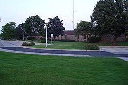
Franklin City Hall
|
|

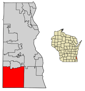
Location of Franklin in Milwaukee County, Wisconsin.
|
|
| County | Milwaukee |
| Founded | 1841 |
| Incorporated | 1956 |
| Area | |
| • Total | 34.68 sq mi (89.82 km2) |
| • Land | 34.58 sq mi (89.55 km2) |
| • Water | 0.10 sq mi (0.27 km2) |
| Elevation | 790 ft (241 m) |
| Population
(2020)
|
|
| • Total | 36,816 |
| • Estimate
(2021)
|
36,624 |
| • Density | 1,035.75/sq mi (399.91/km2) |
| Time zone | UTC−6 (Central) |
| • Summer (DST) | UTC−5 (Central) |
| ZIP Code |
53132
|
| Area code(s) | 414 |
| FIPS code | 55-27300 |
| GNIS feature ID | 1583234 |
Franklin is a city in Milwaukee County, Wisconsin, United States. It's a part of the larger Milwaukee metropolitan area. In 2020, about 36,816 people lived here.
Contents
History of Franklin
Franklin started as a town on December 20, 1839. It was once a part of the Town of Kinnikinick. The area was covered with thick forests, mostly hardwood trees like hickory and walnut.
The Root River helped drain the land. Many wild animals, including bears and deer, lived there. In 1840, about 248 people lived in Franklin. The town was named after Benjamin Franklin, a famous American.
By the 1950s, Franklin became known as a "City of Homes." Many people moved there, making it a suburb of Milwaukee. In 1956, leaders in Franklin were worried that Milwaukee might try to take over parts of their town. To prevent this, Franklin officially became a city on August 15, 1956.
Geography of Franklin
Franklin is located at 42.899166 degrees North and 88.002204 degrees West. It shares borders with several other cities and villages. To the east is Oak Creek. To the north are Greendale, Hales Corners, and Greenfield. To the south is Racine County, and to the west is Waukesha County.
The city covers about 34.69 square miles (89.82 square kilometers). Most of this area, about 34.58 square miles (89.55 square kilometers), is land. A small part, about 0.11 square miles (0.27 square kilometers), is water. The Root River flows south through Franklin, dividing the city.
Population and People
| Historical population | |||
|---|---|---|---|
| Census | Pop. | %± | |
| 1960 | 10,006 | — | |
| 1970 | 12,247 | 22.4% | |
| 1980 | 16,871 | 37.8% | |
| 1990 | 21,855 | 29.5% | |
| 2000 | 29,494 | 35.0% | |
| 2010 | 35,451 | 20.2% | |
| 2020 | 36,816 | 3.9% | |
| 2021 (est.) | 36,624 | 3.3% | |
| U.S. Decennial Census | |||
In 2010, Franklin had 35,451 people living in 13,642 households. The city had about 1025 people per square mile. Most households were married couples living together. About 21.6% of residents were under 18 years old. The average age in the city was 41.5 years.
Economy of Franklin
Franklin has many businesses that provide jobs for its residents. Here are some of the top employers in the city:
| # | Employer | # of Employees |
|---|---|---|
| 1 | Northwestern Mutual | 2,550 |
| 2 | Wheaton Franciscan Healthcare | 712 |
| 3 | Franklin Public School District | 543 |
| 4 | Krones | 450 |
| 5 | GA Precision | 364 |
| 6 | Milwaukee County Corrections South | 360 |
| 7 | Walmart | 357 |
| 8 | Carlisle Interconnect Technologies | 270 |
| 9 | Central Aquatics | 261 |
| 10 | Strauss Brands | 250 |
Education in Franklin
Most students in Franklin go to schools in the Franklin Public School District. This district was created in 1962 and serves students from kindergarten through 12th grade. Franklin has five elementary schools, one middle school, and one high school. The school district also runs the Franklin Recreation Department.
Some parts of Franklin are served by other school districts. The Oak Creek-Franklin School District serves the eastern side of Franklin. The Whitnall School District serves the far northwest side of the city.
Franklin also has private schools. St. Pauls Lutheran K4–8 was started in 1865. The Indian Community School of Milwaukee K4–8 serves Native American children and youth.
Transportation in Franklin
Franklin is located about 4 miles (6.4 km) from Milwaukee Mitchell International Airport. It is also close to Interstate 94, a major highway. Several other highways run through the city, including U.S. Highway 45, WIS 36, WIS 100, and WIS 241.
In the past, the St. Martins Junction in Franklin was a stop for two interurban train lines. These lines connected Franklin to other towns like Burlington and East Troy.
Environmental Efforts
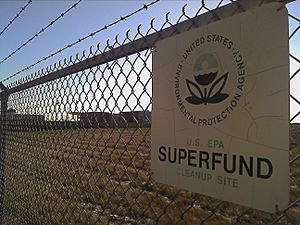
Franklin is home to a former Environmental Protection Agency Superfund site. This site, called the "Fadrowski Drum Disposal Site," was about 40 acres (16 hectares) in size. It was found to have harmful chemicals like lead and chromium. Small amounts of arsenic, DDT, and mercury were also found. There was even a pond with high levels of cyanide.
The site was added to a national list of polluted sites in 1986. Cleanup work was finished in 1994, and the site was removed from the list in 2003. The cleanup involved removing some waste, taking out bad soil, and putting a special cover over the landfill. They also monitored the water in the ground and on the surface.
Even though much of the site is cleaned up, some waste material remains. The U.S. Environmental Protection Agency checks the site every five years to make sure it stays safe. People are not allowed to use the site for drinking water, build homes there, or do anything that would disturb the special landfill cover. Today, the area around the site has many businesses. A part of the site is being considered for a dog park.
Notable People from Franklin
- Eric Bugenhagen, Professional wrestler
- Peter Doyle, former Wisconsin Secretary of State
- Michael Egan, former state senator and representative
- Sam Mayer, racing driver
- Scott Mayer, racing driver
- Ted Musgrave, NASCAR driver
- Bill Prietzel, racing driver known as the "Franklin Flyer"
- Janet Protasiewicz, Justice of the Wisconsin Supreme Court
- Jessie Rodriguez, advocate and politician
- Ken Skowronski, Wisconsin State Representative
See also
 In Spanish: Franklin (ciudad) para niños
 | Bayard Rustin |
 | Jeannette Carter |
 | Jeremiah A. Brown |


