Fremont Pass (Colorado) facts for kids
Quick facts for kids Fremont Pass |
|
|---|---|

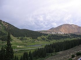
Fremont Pass and the Climax mine
|
|
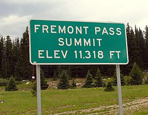
| Elevation | 11,318 ft (3,450 m) |
| Traversed by | |
| Location | Lake County, Colorado, United States |
| Range | Rocky Mountains |
| Coordinates | 39°21′59″N 106°11′12″W / 39.36639°N 106.18667°W |
| Topo map | USGS Climax |
Fremont Pass is a very high mountain pass in the middle of Colorado, located in the amazing Rocky Mountains of the western United States. It sits at an elevation of 11,318-foot (3,450 m), which is more than 11,000 feet above sea level!
This pass is special because it forms part of the continental divide. This is like a giant invisible line across North America that separates which ocean rivers flow into. Fremont Pass is also right on the border between Lake County and Summit County.
The pass was named after John C. Frémont, a famous explorer. He traveled through the American West in the 1840s and discovered this pass while exploring what is now Colorado. Fremont Pass connects the upper part of the Blue River (which flows into the Colorado River) with the beginning of the Arkansas River to the south.
Right at the top of the pass, you'll find the Climax mine. This is a large mine that digs for a metal called molybdenum. Even though it's one of the highest mountain passes in Colorado, most of the road is quite gentle. The only really steep part is a switchback (a sharp, winding turn) as you get close to the Climax mine on the south side. You can drive over the pass using State Highway 91.
Trains and the Pass
Trains once traveled over Fremont Pass, carrying goods and people.
Early Railways
The Denver, South Park and Pacific Railroad built a special narrow gauge railway line here in 1884. Narrow gauge means the tracks are closer together than standard tracks. This railway was later sold and became part of the Colorado and Southern Railway. It stopped running in 1937.
However, part of the line south of Climax is still used today! It was changed to a standard track width in 1943 and is now operated by the Leadville, Colorado and Southern Railroad.
Another Rail Line
Another narrow gauge railway was built by the Denver and Rio Grande Railroad in 1881. This line stopped carrying passengers in late 1909. It only carried freight (goods) for a little longer, stopping completely in November 1910. This second railway line was taken apart on December 1, 1923.
Powering the Region
In 1909, a very important power line was built called the Shoshone Transmission Line. This line was designed to carry electricity from a power plant near Glenwood Springs all the way to cities like Leadville and Denver.
This historic electric line has been updated many times over the years and is still used today! However, because the Climax mine has grown so much, the power line near Fremont Pass has had to be changed quite a bit.
 | Audre Lorde |
 | John Berry Meachum |
 | Ferdinand Lee Barnett |


