Gaithersburg, Maryland facts for kids
Quick facts for kids
Gaithersburg, Maryland
|
|||||
|---|---|---|---|---|---|
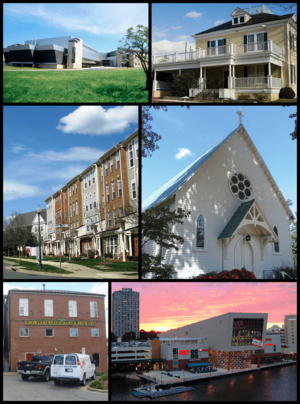
Top to bottom, left to right: the NIST Advanced Measurement Laboratory, the Gaithersburg city hall, a row of Gaithersburg townhouses, the Saint Rose of Lima Catholic Church, the John A. Belt Building, and the Washingtonian Waterfront
|
|||||
|
|||||
| Nickname(s):
"GBurg"
|
|||||
| Motto(s):
"A Character Counts! city"
|
|||||
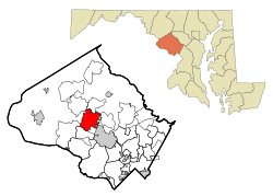
Location in Montgomery County and Maryland
|
|||||
| Country | |||||
| State | |||||
| County | |||||
| Settled (as Log Town) | 1765 | ||||
| Founded | 1802 | ||||
| Incorporated (as a town) | April 5, 1878 | ||||
| Ascension (to city status) | 1968 | ||||
| Named for | Benjamin Gaither | ||||
| Area | |||||
| • Total | 10.44 sq mi (27.05 km2) | ||||
| • Land | 10.32 sq mi (26.73 km2) | ||||
| • Water | 0.12 sq mi (0.32 km2) | ||||
| Elevation | 350 ft (110 m) | ||||
| Population
(2020)
|
|||||
| • Total | 69,657 | ||||
| • Density | 6,749.06/sq mi (2,605.78/km2) | ||||
| Time zone | UTC−5 (EST) | ||||
| • Summer (DST) | UTC−4 (EDT) | ||||
| Area codes | 301, 240 | ||||
| FIPS code | 24-31175 | ||||
| GNIS feature ID | 2390591 | ||||
Gaithersburg (pronounced GAY-thərz-burg) is a city in Montgomery County, Maryland, United States. In 2020, about 69,657 people lived there. This makes it the ninth-largest community in Maryland.
Gaithersburg is located northwest of Washington, D.C.. It is a suburb and a main city within the larger Washington metropolitan area. Gaithersburg became a town in 1878 and a city in 1968.
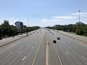
The city is split by Interstate 270. The eastern part has the historic area, known as "Olde Towne." You can still see old buildings and landmarks there. This side also has City Hall, the Montgomery County Fairgrounds, and Bohrer Park. Bohrer Park is a popular recreation center with an outdoor water park.
The western part of Gaithersburg has many newer neighborhoods. These areas were planned using "smart growth" ideas. They include communities like Kentlands, Lakelands, and the Washingtonian Center (also called Rio). Rio is a big shopping and business area. New communities like Watkins Mill Town Center and "Science City" are also being built.
Big companies like the National Institute of Standards and Technology (NIST) have their main offices in Gaithersburg. Other major employers include IBM, Lockheed Martin, and AstraZeneca. The United States Army Reserve Legal Command is also based here.
Gaithersburg is known for its many different cultures and people. In 2021 and 2023, it was ranked as one of the most diverse cities in the U.S.
Contents
History of Gaithersburg
Gaithersburg started as a small farming village in 1765. It was first called Log Town. This was near a place called Summit Hall.
In 1802, a man named Benjamin Gaither built his home on the land. The area later became known as Gaithersburg.
Gaithersburg in the 1800s
In 1851, the Forest Oak Post Office opened in Gaither's store. It was named after a large tree in the town.
During the American Civil War, over 10,000 Confederate soldiers camped in the area in 1864. They were marching towards Washington, D.C.
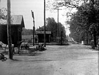
When the railroad was built in 1873, the new train station was named Gaithersburg. This made the name official for the community. The Baltimore and Ohio Railroad built a station designed by Ephraim Francis Baldwin.
The town grew quickly after the railroad arrived. On April 5, 1878, Gaithersburg officially became a town. Churches, schools, stores, and hotels were built. Most of this growth happened around the train station.
In 1899, Gaithersburg was chosen for a special project. It became one of six places in the world to have an International Latitude Observatory. This observatory helped scientists measure how the Earth wobbles on its axis. The Gaithersburg Latitude Observatory is a National Historic Landmark. It helped scientists understand the Earth's shape and movement. The station worked until 1982.
Gaithersburg in the Late 1900s
In 1968, Gaithersburg changed from a town to a city.
Until the 1970s, Gaithersburg was mostly a rural farm town. Then, more buildings and homes were constructed. The population grew, and Gaithersburg started to feel more like a suburb. It left its farming past behind.
By the late 1990s, Gaithersburg became very diverse. People from many different backgrounds moved there. This diversity can be seen in local schools. Gaithersburg High School and Watkins Mill High School have many students from different cultures.
In 1997, a big rainstorm caused the 295-year-old Forest Oak tree to fall. This tree was the inspiration for the city's logo and flag.
Gaithersburg in the 2000s
In 2007, parts of the movie Body of Lies were filmed in Gaithersburg. The building used in the film is now the headquarters for the Montgomery County Police Department.
On July 16, 2010, a 3.6 magnitude earthquake was felt in Gaithersburg. It was one of the strongest earthquakes in Maryland.
Lakeforest Mall, a large shopping center, closed on March 31, 2023. It will be torn down and the area will be redeveloped.
Geography and Area
According to the U.S. Census Bureau, Gaithersburg covers about 10.34 square miles (26.78 square kilometers). Most of this area is land. Only a small part is water.
Population and People
| Historical population | |||
|---|---|---|---|
| Census | Pop. | %± | |
| 1900 | 547 | — | |
| 1910 | 625 | 14.3% | |
| 1920 | 729 | 16.6% | |
| 1930 | 1,068 | 46.5% | |
| 1940 | 1,021 | −4.4% | |
| 1950 | 1,755 | 71.9% | |
| 1960 | 3,847 | 119.2% | |
| 1970 | 8,344 | 116.9% | |
| 1980 | 26,424 | 216.7% | |
| 1990 | 39,542 | 49.6% | |
| 2000 | 52,613 | 33.1% | |
| 2010 | 59,933 | 13.9% | |
| 2020 | 69,657 | 16.2% | |
| U.S. Decennial Census 2010–2020 |
|||
The population of Gaithersburg has grown a lot over the years. In 1900, there were only 547 people. By 2020, the population was 69,657.
Population in 2022
In 2022, there were about 68,952 people living in Gaithersburg. The city is very diverse:
- About 33% of people were White.
- About 13% were Black.
- About 15% were Asian.
- About 36% were Hispanic.
The average income for a household was about $95,453. About 6% of people lived below the poverty line.
Most people in Gaithersburg drive to work. The average commute time was 30 minutes.
Economy and Jobs
Gaithersburg has many important employers. Here are some of the top ones:
| # | Employer | # of Employees |
|---|---|---|
| 1 | AstraZeneca (formerly MedImmune) | 4,000 |
| 2 | National Institute of Standards and Technology | 2,798 |
| 3 | Leidos (merged with Lockheed Martin) | 1,515 |
| 4 | Asbury Methodist Village | 771 |
| 5 | Hughes Network Systems, LLC | 729 |
| 6 | Sodexo USA | 536 |
| 7 | Adventist HealthCare | 495 |
| 8 | GeneDx | 350 |
| 9 | Kaiser Permanente | 350 |
| 10 | Emergent BioSolutions | 347 |
Gaithersburg also hosts many important conferences. Patton Electronics, a technology company, was founded here in 1984.
Education and Schools
Gaithersburg is part of the Montgomery County Public Schools system. Many schools are located within the city.
Elementary schools
- Brown Station
- Darnestown
- Diamond
- DuFief
- Fields Road
- Flower Hill
- Gaithersburg
- Goshen
- Harriet R. Tubman
- Jones Lane
- Judith A. Resnik
- Laytonsville
- Rachel Carson
- Rosemont
- South Lake
- Stedwick
- Strawberry Knoll
- Summit Hall
- Thurgood Marshall
- Washington Grove
- Watkins Mill
- Whetstone
- Woodfield
Middle schools
- Forest Oak
- Gaithersburg
- Lakelands Park Middle School
- Ridgeview
- Shady Grove
High schools
- Gaithersburg High School
- Quince Orchard High School
- Watkins Mill High School
Media and News
Gaithersburg gets its news and media from the larger Washington, D.C. area.
Newspapers
- The Town Courier is a local newspaper. It focuses on Gaithersburg's western neighborhoods. It also has editions for Rockville and Urbana.
City Services and Transportation
Police Department
Gaithersburg has its own police department. The Gaithersburg Police Department was started in 1963.
Roads and Highways
The main highways in Gaithersburg are Interstate 270 and Interstate 370. I-270 goes northwest from Interstate 495 (the Capital Beltway). I-370 is a short road that connects to Maryland Route 200. This route links Gaithersburg to Interstate 95.
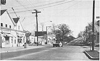
Maryland Route 355 is an older road that runs parallel to I-270. It is now a main street with many businesses. Other state roads include Maryland Route 117, Maryland Route 119, and Maryland Route 124.
Public Transportation
Gaithersburg is connected to the Washington Metro subway system. The Shady Grove station is just outside the city. It is the last stop on the Red Line.
The Corridor Cities Transitway is a planned bus rapid transit line. It will have eight stops in the western part of Gaithersburg.
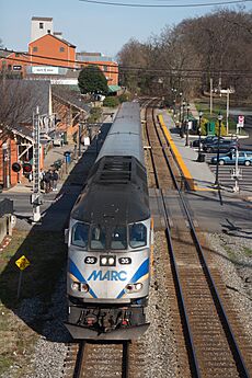
Maryland's MARC system offers commuter rail services. These trains connect Gaithersburg to Washington, D.C.. There are two MARC stations in the city: Old Town Gaithersburg and Metropolitan Grove. Another station, Washington Grove, is nearby.
Bus services in Gaithersburg include Metrobus and Ride-On routes.
Airport
The Montgomery County Airpark is located about 3 miles (5 kilometers) northeast of Gaithersburg.
Notable People from Gaithersburg
Many interesting people have lived in or are from Gaithersburg:
- Utkarsh Ambudkar, actor and rapper
- Kimberly J. Brown, actress from Halloweentown
- Justin Carter, basketball player
- Kiran Chetry, CNN news anchor
- Chris Coghlan, Major League Baseball player
- Dominique Dawes, Olympic gymnast, part of the "Magnificent Seven" team
- Stefon Diggs, football player for the Houston Texans
- Trevon Diggs, football player for the Dallas Cowboys
- Judah Friedlander, actor from 30 Rock
- Jake Funk, football player and Super Bowl LVI champion
- Dwayne Haskins, NFL quarterback
- Paul James, actor from Greek
- Kelela, R&B singer
- Courtney Kupets, Olympic gymnast
- Tim Kurkjian, ESPN baseball analyst
- Logic (Robert Bryson Hall II), hip hop musician
- Lucas and Marcus, dancers and YouTube personalities
- Shane McMahon, WWE wrestler
- Malcolm Miller, basketball player and NBA champion
- Nick Mullen, comedian
- Paul Rabil, lacrosse player
- Jodie Turner-Smith, actress and model
- Wale, hip hop musician
- Jessica Watkins, NASA astronaut
- James White, basketball player
- Chop Robinson, football player for the Miami Dolphins
See also
 In Spanish: Gaithersburg (Maryland) para niños


