Ganargua Creek facts for kids
Quick facts for kids Ganargua Creek |
|
|---|---|

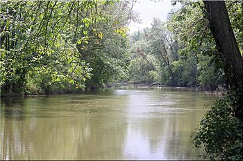
Ganargua Creek, looking upstream, from Norsen Bridge Park near Newark, New York.
|
|
| Other name(s) | Mud Creek |
| Country | United States |
| State | New York |
| Region | Finger Lakes |
| Physical characteristics | |
| Main source | Confluence of Mud Creek, Fish Creek and Great Brook Victor, Ontario County, New York, United States 547 ft (167 m) 42°58′48″N 77°23′14″W / 42.98000°N 77.38722°W |
| River mouth | Erie Canal Lyons, Wayne County, New York, United States 397 ft (121 m) 43°03′48″N 77°00′11″W / 43.06333°N 77.00306°W |
| Length | 34 mi (55 km) |
| Basin features | |
| Basin size | 118 sq mi (310 km2) |
| Tributaries |
|
Ganargua Creek, also called Mud Creek, is an important waterway in New York State. It flows into the Erie Canal and the Clyde River. The creek starts near the village of Victor in Ontario County. It then travels about 34 miles (55 kilometers) from west to east. Finally, it joins the Erie Canal in the town of Lyons.
Ganargua Creek is actually split into two parts. For about 3 miles (5 kilometers), it flows right alongside the Erie Canal near Palmyra. Many smaller streams and brooks flow into Ganargua Creek along its path. This creek is part of a larger system that eventually leads to Lake Ontario.
The name "Ganargua" comes from the Iroquois people, who were the first inhabitants of this area. It means "where the village sprang up" or "a village suddenly sprang up." The nickname 'Mud Creek' comes from the water often looking murky or muddy. Ganargua Creek is a popular spot for fishing, canoeing, and kayaking. However, paddling can be tricky because of fallen trees. These trees created log jams after big ice storms in 1991 and 2003.
Contents
Where Does Ganargua Creek Flow?
Ganargua Creek has two main sections: a southern part and a northern part. These sections are sometimes called the "Upper" and "Lower" creek on official maps.
The Southern Section of the Creek
The southern part of Ganargua Creek is about 13 miles (21 kilometers) long. It begins in Ontario County near the town of Victor. Here, three smaller streams—Mud Creek, Fish Creek, and Great Brook—all meet to form Ganargua Creek. The main source of water for the creek is Mud Creek, which starts further south near Bristol Mountain.
From this starting point, Ganargua Creek flows north and then east. It passes through the western part of Farmington and goes under the New York State Thruway. Then, it enters Wayne County. The creek winds its way through the town and village of Macedon. It eventually meets the Erie Canal just east of Lock #29 in Palmyra. Before joining the canal, the creek flows past the remains of the Palmyra Aqueduct, which was built in 1857. After this, Ganargua Creek flows together with the Erie Canal for about three miles before splitting off again.
The Northern Section of the Creek
The northern part of Ganargua Creek is about 18 miles (29 kilometers) long. It starts in Wayne County, in the town of Palmyra. This section begins at a spillway from the Erie Canal, near Swifts Landing Park. You can reach this area from the Erie Canalway Trail.
The creek flows northeast towards East Palmyra and into the town of Arcadia. It follows the CSX Transportation railroad line. It passes just north of the village of Newark and continues northeast along the Ontario Midland Railroad line. It reaches Norsen Bridge Park, near Fairville Station. From there, Ganargua Creek turns southeast. It flows along Bauer-Van Wickle Road and Layton Street into the town and hamlet of Lyons. Finally, it enters the Erie Canal at Miller's Marina, near Abbey Park. This northern section between Palmyra and Lyons is the best part for paddling, as the southern section is often too shallow.
What Are the Tributaries of Ganargua Creek?
Eight main streams, called tributaries, feed into Ganargua Creek. Many other smaller waterways also flow into it.
- Mud Creek, Fish Creek, and Great Brook: These three streams come together near Victor to form the very beginning of Ganargua Creek.
- Trap Brook: This stream flows into the creek from the right side in Macedon.
- Hathaway Brook: This stream is in Palmyra and actually flows into the Erie Canal, which Ganargua Creek also connects with.
- Red Creek (Western): This stream flows through Walworth, Macedon, and Palmyra. It joins Ganargua Creek at the spillway.
- Red Creek (Eastern): Not far from the western Red Creek, this one runs through Marion and Palmyra. It enters Ganargua Creek near East Palmyra.
- Butternut Run: This tributary is located in the town of Lyons.
History of Ganargua Creek
People have used Ganargua Creek for a very long time, even before colonial times. The Iroquois people used it as an important stop on their trade routes. Mormonism founder Joseph Smith was also interested in the creek. He heard a speech from Seneca Chief Red Jacket in Palmyra in 1822. Before the Erie Canal was built in 1817, Ganargua Creek used to meet the Canandaigua Outlet in Lyons. Together, they formed the Clyde River.
Parks and Trails Along the Creek
Several parks and hiking trails are located along Ganargua Creek, mostly in Wayne County. These include:
- Ganargua Creek Meadow Preserve in Macedon
- Gravino Park in Macedon
- Aqueduct Park in Palmyra
- The Erie Canalway Trail in Palmyra
- Swifts Landing Park near Palmyra
- Norsen Bridge Park near Newark
- Abbey Park in Lyons
 | Percy Lavon Julian |
 | Katherine Johnson |
 | George Washington Carver |
 | Annie Easley |

