Municipal District of Bighorn No. 8 facts for kids
Quick facts for kids
Municipal District of Bighorn No. 8
|
||
|---|---|---|
|
||

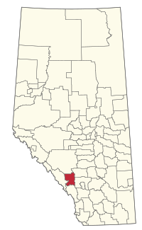
Location within Alberta
|
||
| Country | Canada | |
| Province | Alberta | |
| Region | Calgary Region | |
| Census division | 15 | |
| Incorporated | 1988 | |
| Area
(2021)
|
||
| • Land | 2,678.8 km2 (1,034.3 sq mi) | |
| Population
(2021)
|
||
| • Total | 1,598 | |
| • Density | 0.6/km2 (2/sq mi) | |
| Time zone | UTC−7 (MST) | |
| • Summer (DST) | UTC−6 (MDT) | |
The Municipal District of Bighorn No. 8 is a special type of local government area in Alberta, Canada. Think of it like a big county that manages services for the people living there. It's located between the big city of Calgary and the beautiful Banff National Park. You can find it just north of the Kananaskis Improvement District. A major road, Highway 1 (also known as the Trans-Canada Highway), goes right through this area.
The MD of Bighorn No. 8 was officially created on January 1, 1988. Before that, it was called Improvement District No. 8. The popular Town of Canmore is right next to the southwest part of the municipal district.
Contents
Communities and Localities in Bighorn
This section lists the different towns and small communities you can find in or around the MD of Bighorn No. 8.
Urban Areas Near Bighorn
These are towns and villages that are surrounded by the MD of Bighorn No. 8.
- Canmore (a town)
- Ghost Lake (a summer village)
- Waiparous (a summer village)
- Mînî Thnî (a First Nations settlement)
Hamlets Within Bighorn
These smaller communities are located directly inside the MD of Bighorn No. 8.
- Benchlands
- Dead Man's Flats (also known as Pigeon Mountain)
- Exshaw
- Harvie Heights
- Lac des Arcs
Other Localities in Bighorn
These are even smaller places or areas within the MD of Bighorn No. 8.
- Gap
- Improvement District No. 8
- Jumping Pound (Forest Res)
- Kananaskis
- Spray Lakes
Population and People of Bighorn
This section tells us about how many people live in the MD of Bighorn No. 8.
Recent Population Changes
In 2021, Statistics Canada counted the population of the MD of Bighorn No. 8. There were 1,598 people living in 640 homes. This was a good increase from 2016, when the population was 1,324 people.
Land Area and Density
The total land area of the MD of Bighorn No. 8 is about 2,678.8 square kilometers (or 1,034.3 square miles). This means that in 2021, there were only about 0.6 people living per square kilometer. This shows it's a very spread-out area with lots of open space!
In 2016, the population was 1,334 people. The land area was slightly larger then, at 2,761.18 square kilometers.
 | Jackie Robinson |
 | Jack Johnson |
 | Althea Gibson |
 | Arthur Ashe |
 | Muhammad Ali |


