Garfield Peak (Oregon) facts for kids
Quick facts for kids Garfield Peak |
|
|---|---|

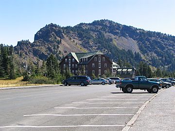
Crater Lake Lodge and Garfield Peak in the background
|
|
| Highest point | |
| Elevation | 7,976 ft (2,431 m) |
| Prominence | 334 ft (102 m) |
| Geography | |
| Location | Klamath County, Oregon, U.S. |
| Parent range | Cascades |
| Topo map | USGS Crater Lake West |
| Geology | |
| Volcanic arc | Cascade Volcanic Arc |
| Climbing | |
| Easiest route | Trail from Crater Lake Lodge |
Garfield Peak is a mountain found on the south side of Crater Lake in Crater Lake National Park, Oregon. It stands tall at about 7,976 feet (2,431 meters) above sea level. A popular hiking trail leads to its top from the Crater Lake Lodge. This trail climbs about 1,000 feet (305 meters) to reach the summit. The trail is about 1.7 miles (2.7 kilometers) long. From Garfield Peak, the trail continues east towards Applegate Peak. Garfield Peak is one of seven peaks around Crater Lake that are over 8,000 feet (2,438 meters) high.
Contents
History of Garfield Peak
Garfield Peak was named to honor James Rudolph Garfield. He was the United States Secretary of the Interior for President Theodore Roosevelt. President Roosevelt created Crater Lake National Park in 1902. James Garfield visited the park in 1907. He was the first cabinet member to visit Crater Lake.
Geology: How Garfield Peak Formed
Garfield Peak was formed after Mount Mazama erupted. Mount Mazama was a huge stratovolcano. It exploded about 7,700 years ago. Garfield Peak is part of the rim of the volcano's caldera. This caldera is now filled with Crater Lake.
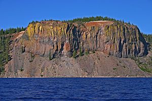
The rocks along the southern rim of Crater Lake have special colors. This is because of sulfur steam from fumaroles. Fumaroles are vents that release volcanic gases. These gases color the rocks, especially on Garfield Peak. You can also see these colors on the Eagle Crags and Applegate trail.
The rock colors often change from red and brown to yellow. The red and brown colors come from the early stages of rock decay. This happens when oxygen, iron, and water mix over a long time. This mix of iron oxide and water creates a mineral called limonite. Limonite has a brown color. If less water is involved, the color turns yellow. When no water is part of the reaction, the rock becomes red. This red mineral is called hematite.
Sometimes, different iron compounds mix together. This can make the rock look greenish. All these different colors and shades can be seen on Garfield Peak. You can also spot them along the hiking trail.
Flora and Fauna: Plants and Animals
Garfield Peak is home to many plants and animals. The mountain is covered with mountain hemlock and Shasta red fir trees. At higher elevations near the summit, you can find whitebark pine and subalpine fir.
Small animals like American pikas and yellow-bellied marmots live here. You can often see them on the rocky slopes along the trail.
Birds of Garfield Peak
Many birds live on Garfield Peak. You can hear their songs all around. The song of Thurber's Junco is interesting. These birds often breed in the mountains of southern Oregon.
Thurber's Juncos look like Oregon Juncos. They have a deep black head, throat, and chest. Their wings and tail are longer. Their sides are more buff than pink. You might see them perched and singing. Females can be seen hopping through rocks and grassy areas. They search for insects and seeds. Their nests are often hidden under the leaves of the trailing black currant plant.
Garfield Peak Trail: A Hiking Adventure
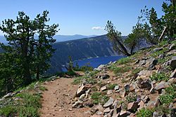
The Garfield Peak trail is a popular hiking route. It follows the western part of Crater Lake's southern rim. Most of the northern sections of the trail offer amazing views of the lake. You can also see its two islands, Wizard Island and Phantom Ship.
The trail is not paved. It runs about 1.7 miles (2.7 kilometers) from Crater Lake Lodge. It climbs about 1,122 feet (342 meters) in elevation. This makes it a moderately challenging hike. From Garfield Peak, the trail continues to a flatter section. This part of the trail goes past Eagle Crags towards Applegate Peak.
The start of the trail is clearly marked. It is on the eastern side of Crater Lake Lodge. It begins with paved paths that offer views of the lake. The pavement soon changes to a dirt trail. This trail is exposed but well-maintained. It leads northeastward. About half a mile from the start, the trail turns north. It then climbs the northwestern ridge of Garfield Peak. The trail slowly turns east. It goes over the northernmost ridge of Garfield Peak to reach the summit.
 | Sharif Bey |
 | Hale Woodruff |
 | Richmond Barthé |
 | Purvis Young |


