
Glarus Nord facts for kids
Quick facts for kids
Glarus Nord
|
||
|---|---|---|

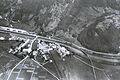
Näfels village
|
||
|
||

Glarus Nord
Location in Switzerland

Glarus Nord
Location in Canton of Glarus
|
||
| Country | Switzerland | |
| Canton | Glarus | |
| District | n.a. | |
| Area | ||
| • Total | 146.98 km2 (56.75 sq mi) | |
| Elevation | 437 m (1,434 ft) | |
| Population
(Dec 2020 )
|
||
| • Total | 18,832 | |
| • Density | 128.126/km2 (331.846/sq mi) | |
| Postal code |
8752, 8753, 8757, 8758, 8865–8868, 8874
|
|
| Localities | Bilten, Filzbach, Mollis, Mühlehorn, Näfels, Niederurnen, Oberurnen, Obstalden, Ziegelbrücke. | |
| Surrounded by | Schänis (SG), Weesen (SG), Amden (SG), Quarten (SG), Glarus Süd, Glarus, Innerthal (SZ), Schübelbach (SZ), Reichenburg (SZ), Benken (SG) | |

Glarus Nord is a municipality (like a town or district) in the canton of Glarus, Switzerland. It's one of three main areas in this canton, along with Glarus and Glarus Süd.
Since 2011, Glarus Nord includes several smaller villages that used to be separate municipalities. These are Bilten, Filzbach, Mollis, Mühlehorn, Näfels, Niederurnen, Oberurnen, and Obstalden.
Contents
- History of Glarus Nord's Villages
- Bilten: From Roman Times to Modern Industry
- Filzbach: A Village with Roman Roots and Lake Views
- Mollis: From Ancient Temples to Airfields
- Mühlehorn: A Quiet Village by the Lake
- Näfels: Site of a Famous Battle
- Niederurnen: An Early Settlement
- Oberurnen: Another Historic Village
- Obstalden: Mentioned in the 1300s
- Geography and Landscape
- Population and Demographics
- Historical Population Changes
- Important Heritage Sites
- Economy and Jobs
- Transportation Links
- Notable People from Glarus Nord
- Images for kids
- See also
History of Glarus Nord's Villages
Glarus Nord was formed in 2011 by combining eight smaller municipalities. Each of these villages has its own interesting history.
Bilten: From Roman Times to Modern Industry


Bilten was first mentioned way back in 1050. People probably lived here even during the Roman era. For a long time, a place called Schänis Abbey owned much of the village.
In the 1500s, most people in Bilten changed their religion during the Protestant Reformation. A new church was built in 1607. Farmers in Bilten used to raise animals for sale. Later, they started focusing on dairy cattle and selling dairy products.
The Linth river used to cause problems with swamps and diseases, but a big project in the early 1800s fixed this. The village got its first school in 1839. In 1875, a railway line connected Bilten to other towns.
Bilten was mostly a farming village until the mid-1900s. Then, factories started to open, especially after the A3 motorway was built in 1973. This made it easy to transport goods. By 1990, most people in Bilten worked in industry.
Filzbach: A Village with Roman Roots and Lake Views

Filzbach was first mentioned in 1394. There are ruins of a Roman watchtower from around 20 BC, showing that Romans were here a very long time ago!
Filzbach became part of Glarus after a battle in 1386. Like Bilten, its people also adopted the Reformed faith in 1528. Farmers here used to grow food for themselves. Later, they focused on fruit trees and then on raising animals in the mountains.
In the 1700s, many families started making cloth at home to earn extra money. A silk factory opened in 1889, but it closed in 1990. Tourism also grew, especially after a road was built along Walen Lake. Two chair lifts were added, making it easier for visitors to enjoy the area. The village school, built in 1838, is still used today.
Mollis: From Ancient Temples to Airfields


Mollis was first mentioned in 1288. An old Gallo-Roman temple was found here, built almost 2,000 years ago! Parts of a medieval fort were also built nearby after a battle in 1388.
The village chapel was built in 1280 and became a church in 1319. In the 1500s, the Reformation changed the church, but some people stayed Catholic. The current church was built in 1761.
For a long time, Mollis relied on farming and herding. Later, farmers switched to dairy cows. In the 1700s, many people started spinning cotton yarn at home, which helped the village become richer. Many men from Mollis also became officers in foreign armies, earning the village the nickname "Aristocrats' Nest."
In the early 1800s, a canal and river project helped solve old arguments about land borders. Roads and railways were built, connecting Mollis to other places. Factories also opened, like a spinning and weaving factory in 1856.
Mollis built a school in 1862. A military airfield was built in 1936, and it became a civilian airfield in 2005.
Mühlehorn: A Quiet Village by the Lake
Mühlehorn was first mentioned in 1551. It's a smaller village with a long history.
Näfels: Site of a Famous Battle
Näfels was first mentioned in 1240. It's famous for the Battle of Näfels in 1388, where the Swiss Confederates defeated the Habsburgs.
Niederurnen: An Early Settlement
Niederurnen was first mentioned between 1045 and 1101, making it one of the older settlements in the area.
Oberurnen: Another Historic Village
Oberurnen was first mentioned in 1340.
Obstalden: Mentioned in the 1300s
Obstalden was first mentioned in 1310.
Geography and Landscape

Glarus Nord covers a total area of about 147 square kilometers (about 57 square miles). A large part of this land is covered by forests (40.5%). About 37.2% is used for farming. Around 6% of the land has buildings or roads, and 16.3% is unproductive land, like mountains.
Over the last 20 years, the amount of land with buildings has grown, while farmland has decreased.
Population and Demographics
Glarus Nord has a population of about 16,438 people (as of 2009). As of 2013, about 22.6% of the people living here are foreign nationals. The population has been growing.
In 2013, children and teenagers (ages 0-19) made up about 20.5% of the population. Adults (ages 20-64) were 62.9%, and seniors (over 64) were 16.6%.
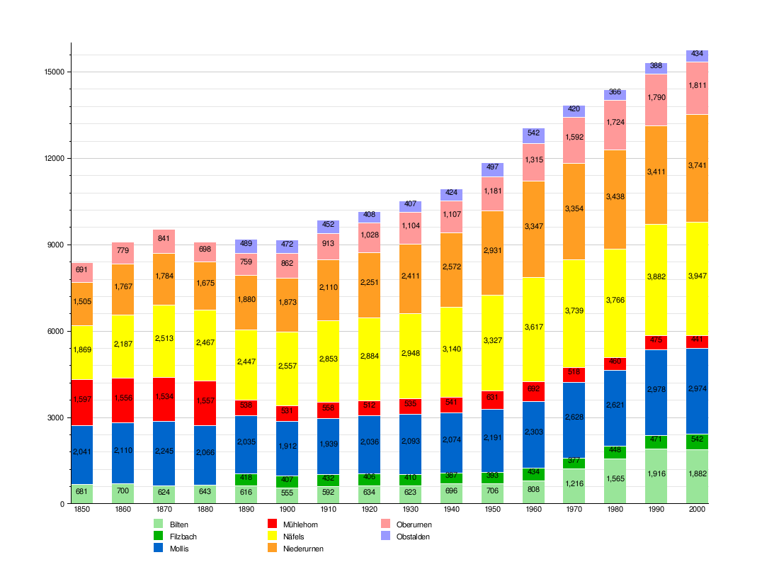
Historical Population Changes
The chart below shows how the population of the different villages that now form Glarus Nord has changed over time. Each color represents a different village.
Important Heritage Sites
Glarus Nord is home to ten important heritage sites that are recognized nationally. These are places with special historical or cultural value.
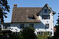
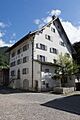
- In Bilten, you can find the Elsener house, a beautiful old building.
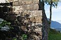
- Filzbach has the ruins of a Roman watchtower called Vor dem Wald.
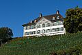
- Mollis has three sites: the Herrensitz Haltli, the Hof and Höfli with a garden, and the Zwicky house.
- Näfels also has three sites: the Freuler Palace (which is now a museum), the Catholic Church of St. Hilarius, and the medieval fort called the Letzi.
- Mühlehorn has the Hammerschmiede (a hammer forge).
- Niederurnen has the Jenny & Co. industrial plant.
There are also three sites listed on the Inventory of Swiss Heritage Sites: the entire village of Mollis, the village of Näfels, and the Jenny & Co. factory site in Ziegelbrücke.
The Roman Watchtower: Vor dem Wald
The remains of the Roman watchtower Vor dem Wald are on rocky hills above Walen Lake. It was first mentioned in 1846 and explored by archaeologists in the 1950s.
The watchtower was a rectangular stone tower, about 13.7 by 12 meters (45 by 39 feet) at its base. It had a water tank inside and an oval, walled courtyard. Pottery and weapons found there show that the tower was used around 20 BC, during the time of Emperor Augustus. It was likely built to help the Roman army during their campaign in the Alps in 15 BC.
Economy and Jobs
As of 2012, there were 8,330 people working in Glarus Nord.
- About 425 people worked in 158 businesses related to farming and natural resources (the primary economic sector).
- About 3,487 people worked in 263 businesses in manufacturing and industry (the secondary sector).
- About 4,418 people worked in 878 businesses in services, like shops, offices, and tourism (the tertiary sector).
In 2013, a small number of people (3.7%) received social assistance.
Transportation Links
Glarus Nord is located on the A3 motorway, which makes it easy to travel by car.
The municipality also has five railway stations, with four of them currently active:
- Bilten station is on the Lake Zürich left-bank railway line. It's a stop for the Zürich S-Bahn S2 train, which connects Zürich and Ziegelbrücke. Ziegelbrücke railway station, which is just outside Glarus Nord, also serves faster long-distance trains.
- Nieder- and Oberurnen and Näfels-Mollis stations are on the Ziegelbrücke–Linthal line. These stations are served by the Zürich S-Bahn S25 train (between Linthal and Zürich) and the St. Gallen S-Bahn S6 train (between Rapperswil and Schwanden). These trains run hourly, so you can usually find two trains per hour between Ziegelbrücke and Schwanden.
- Mühlehorn station is on the Ziegelbrücke–Sargans line. It's a stop for the S4 train of the St. Gallen S-Bahn, which travels in a loop towards Sargans and St. Gallen.
- Weesen station used to be on the Ziegelbrücke–Sargans railway line but has not been used since December 2013. Even though it served the town of Weesen in the canton of St. Gallen, the station itself was located in Glarus Nord.
Notable People from Glarus Nord
Many interesting people have connections to Glarus Nord:
- Karl Josef von Bachmann (1734 in Näfels – 1792): He was a commander of the Swiss Guard for King Louis XVI in France and was executed during the French Revolution.
- Niklaus Franz von Bachmann (1740 in Näfels – 1831 in Näfels): A Swiss general who fought in the Napoleonic Wars.
- Fritz Zwicky (1898–1974): A famous Bulgarian-born American astronomer who is buried in Mollis village.
- Friedrich Schröder (1910 in Näfels – 1972): A German composer known for light music.
- Martin Landolt (born 1968 in Näfels): A politician who is a member of the Swiss National Council.
Images for kids
-
Herrensitz Milt / Elsener House
-
Roman Watchtower
-
Herrensitz Haltli
-
Zwicky House
-
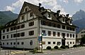
Freuler Palace and Museum of Glarus
-
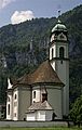
St. Hilarius Parish Church of Näfels
-
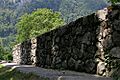
Letzi, Medieval Fortifications
-
Factory Site at Ziegelbrücke


See also
 In Spanish: Glaris Norte para niños
