
Globe facts for kids
A globe is like a round model of something big, like our Earth, another planet, or even the whole sky with its stars. Globes are similar to maps, but they are better because they show shapes and sizes correctly. Maps can sometimes stretch things out.
A globe of Earth is called a terrestrial globe. A globe showing the stars is called a celestial globe.
Globes show lots of details. A terrestrial globe shows continents, oceans, countries, and big cities. It also has lines for latitude and longitude to help you find places. Some globes even have bumpy parts to show mountains! A celestial globe shows stars and can also show where other space objects are. It usually divides the sky into constellations.
The word "globe" comes from the Latin word globus, which means "sphere" or "ball". Globes have been around for a very long time. The first mention of a globe was about 150 BC. The oldest Earth globe still existing is the Erdapfel, made by Martin Behaim in 1492. The oldest celestial globe is on top of the Farnese Atlas, carved in the 2nd century in the Roman Empire.

Contents
Terrestrial and Planetary Globes

Flat maps are made using a special method called a map projection. This method always causes some stretching or squeezing, especially for large areas. A globe is the only way to show Earth without changing the true shape or size of big features like continents and oceans.
Earth's circumference (the distance around it) is about 40 million meters. Many globes are made with a circumference of one meter. This means they are models of Earth at a scale of 1:40 million. Other globes come in many different sizes.
Sometimes, a globe has a bumpy surface to show mountains and valleys. These bumps are usually made much bigger than they are in real life, otherwise you wouldn't be able to see them! Most modern globes also have lines called parallels (for latitude) and meridians (for longitude). These lines help you find the approximate coordinates of a specific place. Globes might also show country borders and names, but these can quickly become outdated as countries change.
Many terrestrial globes have a special diagram called the analemma. This diagram shows how the Sun appears to move in the sky throughout the year.
Globes usually show the North Pole at the top. However, many globes let you spin them around. This way, you can easily look at the southern parts of Earth. It also helps you see the world from different angles, which can change how you think about maps.
Celestial Globes

Celestial globes show where stars appear in the sky. They don't show the Sun, Moon, or planets because these objects move a lot compared to the stars. But, the ecliptic line, which is the path the Sun seems to follow, is usually marked.
History of Globes

People knew Earth was round by the 3rd century BC in Ancient Greece. The first Earth globe was made around that time. The earliest known one was built by Crates of Mallus in the mid-2nd century BC.
No Earth globes from ancient times or the Middle Ages have survived. However, a celestial globe from that time is part of a Greek sculpture called the Farnese Atlas. A Roman copy of this sculpture from the 2nd century AD is in a museum in Italy.
Early Earth globes showing the whole Old World were also made in the Islamic world. For example, a Persian astronomer named Jamal ad-Din brought an Earth globe to China in 1267.
The oldest Earth globe we still have today was made in 1492 by Martin Behaim. He was a German mapmaker, sailor, and merchant. He called his globe the "Nürnberg Terrestrial Globe," but it's now known as the Erdapfel. Before making the globe, Behaim had traveled a lot. He lived in Portugal and sailed with an explorer to West Africa. He started building his globe after returning to Germany in 1490.
Another old globe, the Hunt–Lenox Globe, from about 1510, is famous for the phrase Hic Sunt Dracones, which means “Here be dragons”. A similar globe, about the size of a grapefruit, was found in 2012. It was made from two halves of an ostrich egg and is thought to be from 1504. It might be the oldest globe to show the New World (the Americas).
A copy of a globe showing America was made by Martin Waldseemüller in 1507. Another very modern-looking Earth globe was built by Taqi al-Din at an observatory in Turkey in the 1570s.
The world’s first seamless celestial globe was built by scientists in the Mughal Empire.
Globus IMP devices, which included five-inch globes, were used in Soviet and Russian spacecraft from 1961 to 2002 to help with navigation. In 2001, newer Soyuz spacecraft started using a computer screen with a virtual globe instead.
In the 1800s, small pocket globes (less than 3 inches) were popular. They were a sign of wealth for gentlemen and educational toys for rich children.
How Globes Are Made
Traditionally, globes were made by gluing a printed paper map onto a sphere, often made of wood.
The most common way involves long, thin strips of paper called gores. These strips are narrow at the poles. Small round pieces of paper cover any uneven spots at the poles. The more gores used, the less the paper map needs to be stretched or crumpled to fit the sphere perfectly.
Modern globes are often made from thermoplastic (a type of plastic). Flat plastic disks are printed with a stretched map of one of Earth's hemispheres. A machine then molds this disk into a half-sphere shape. Two half-spheres are then joined together to make a complete globe.
Usually, a globe is set up so its spin axis is tilted 23.5° from straight up. This is the same angle that Earth's spin axis is tilted compared to its orbit around the Sun. This tilt makes it easy to see how seasons change throughout the year.
Famous Globes

- The Unisphere in New York City is the world’s largest geographical globe. It is 120 feet (36.6 m) across.
- Eartha, located in Maine, is currently the world’s largest rotating globe. It is 41 feet (12.5 m) in diameter.
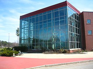
- The Mapparium in Boston is a three-story globe made of stained glass. Visitors can walk through it on a 30-foot glass bridge.
- The Babson globe in Massachusetts is 26 feet (7.9 m) across. It used to spin on its axis and base to show day, night, and seasons.
- The giant globe in the lobby of The News Building in New York City.
- The Hitler Globe, also known as the Columbus Globe for State and Industry Leaders, was a very large and expensive globe made in the 1930s. Several of these globes still exist today in museums and private collections. A much smaller version of this globe was famously made fun of by Charlie Chaplin in his 1940 film The Great Dictator.
Gallery
-
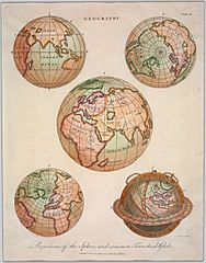
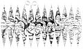
19th Century projections of the terrestrial globe.
-
Martin Behaim with his Erdapfel.
-

Top view of a 1765 de l'Isle globe.
-
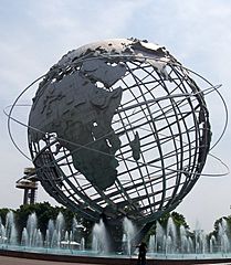
The Unisphere.
-
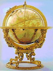
A 1594 mechanised celestial globe.
-
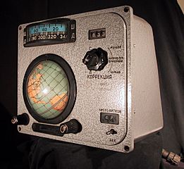
A Globus IMP navigation instrument from a Voskhod spacecraft.
-
Eartha, the largest rotating globe in the world.
-

A map of Mars printed to be folded into a globe.
-
A multitouch spherical globe with a digital Earth.
-
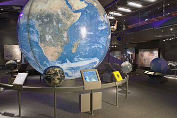
A huge globe with Africa showing at the Naturalis Biodiversity Center.


Images for kids
-
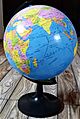
A modern terrestrial globe of Earth.
-
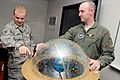
A trainer using a celestial sphere to show a student the Sun's apparent path.
-
Eartha, the largest rotating globe.
-
A 1716 pocket terrestrial globe with its celestial globe case.
-
Top view of a 1765 globe.
-

A mechanised 1594 celestial globe.
-
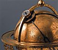
Detail of a 1586 mechanised celestial globe.
-
A 19th century map of Mars, showing how maps are printed to form a globe.
-

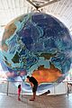
An exhibit with multiple globes of Earth, each showing different information.
-
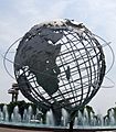
The Unisphere, the largest geographical globe.
-
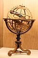
An example of an Armillary sphere.
-
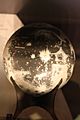
A globe of the Moon.
-

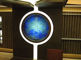
A globe used as a decorative part of a building.
-
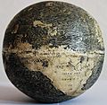
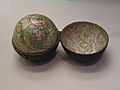
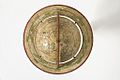
The ca.1504 Ostrich Egg Globe.
-
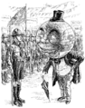
A cartoon of a globe acting like a human.


See also
 In Spanish: Globo terráqueo para niños
