
Golconda, Nevada facts for kids
Quick facts for kids
Golconda, Nevada
|
|
|---|---|
 |
|

Golconda, Nevada
Location in Nevada

Golconda, Nevada
Location in the United States
|
|
| Country | United States |
| State | Nevada |
| County | Humboldt |
| Area | |
| • Total | 1.69 sq mi (4.39 km2) |
| • Land | 1.69 sq mi (4.39 km2) |
| • Water | 0.00 sq mi (0.00 km2) |
| Elevation | 4,423 ft (1,348 m) |
| Population
(2020)
|
|
| • Total | 182 |
| • Density | 107.50/sq mi (41.50/km2) |
| Time zone | UTC-8 (Pacific (PST)) |
| • Summer (DST) | UTC-7 (PDT) |
| ZIP code |
89414
|
| Area code(s) | 775 |
| FIPS code | 32-28500 |
| GNIS feature ID | 2583928 |
| Reference #: | 105 |
Golconda is a small community in Humboldt County, Nevada, United States. It's known as a census-designated place, which means it's a special area counted by the census bureau. In 2020, about 182 people lived there. Golconda is located along Interstate 80, near the Humboldt River, in the northwestern part of Nevada. It has had its own post office since 1869.
Contents
History of Golconda
Golconda was founded because people discovered valuable minerals like copper, silver, gold, and lead nearby. This led to many people coming to open mines and mills in the area.
Early Community Life
The town was home to many different groups of people. This included European Americans, as well as people from France, Portugal, the Paiute tribe, and Chinese people. Everyone lived and worked together in this small mining community.
Growth and Decline
Between 1898 and 1910, Golconda grew quite a bit. It had a train station, several hotels, a school, various businesses, and even local newspapers. The town's population reached its highest point, around 600 people, in 1907-1908.
However, after 1910, the mines started to run out of minerals. This caused the town's population to shrink. Today, Golconda is mostly an area with ranches and farms. Most of the old buildings from its busy mining days are gone. Now, it's a quiet stop along Interstate 80.
Geography and Location
Golconda is located at an elevation of about 4,350 feet (1,326 meters) above sea level. It is about 12 miles (19 kilometers) east of Winnemucca. Golconda is also about 5.7 miles (9.2 kilometers) west of Golconda Summit, which is a mountain pass on Edna Mountain.
Surrounding Areas
The Sonoma Range mountains are located between Golconda and Winnemucca. To the north, across the Humboldt River, you can see the Osgood Mountains. The community also has its own post office.
Land Area
According to the United States Census Bureau, the Golconda census-designated place covers an area of 23.4 square kilometers (9.0 square miles). All of this area is land, with no water.
Population Data
| Historical population | |||
|---|---|---|---|
| Census | Pop. | %± | |
| 2020 | 182 | — | |
| U.S. Decennial Census | |||
The population of Golconda was counted as 182 people in the 2020 census. This number helps us understand how many people live in the area.
See also
 In Spanish: Golconda (Nevada) para niños
Images for kids
-
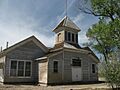
Golconda School is listed on the National Register of Historic Places

