
National Register of Historic Places listings in Nevada facts for kids


Hey there! Did you know that all across Nevada, there are special places that are super important to history? These places are listed on something called the National Register of Historic Places. It's like a big list of old buildings, cool sites, and historic areas that are worth protecting so everyone can learn about them.
Nevada has 16 counties and one independent city, and every single one of them has at least one place on this list! It's pretty amazing to see how much history is packed into our state.
Cool Historic Places in Nevada
The National Register of Historic Places keeps track of all these important spots. Think of it as a way to make sure these places don't get forgotten or torn down. As of April 2008, there were about 375 places listed in Nevada! New places are added all the time, so this number keeps growing.
Here's a quick look at how many places each county in Nevada has on the list:

The Eureka Locomotive, a historic train in Clark County.
|
|

The beautiful Nevada Governor's Mansion in Carson City.
|
||||||||||||||||||||||||||||||||||||||||||||||||||||||||||||
Historic Places by County
Let's explore some of the cool historic places you can find in different Nevada counties!
Carson City
Carson City is Nevada's capital and has many historic buildings. You can find places like the Nevada Governor's Mansion, which is where the state's governor lives.
Churchill County
Churchill County is home to interesting sites, including old courthouses and schools.
- Carson River Diversion Dam: This dam, built in 1981, helps control the Carson River near Fallon.
- Churchill County Courthouse: Located in Fallon, this historic building was listed in 1992.
- Cold Springs Pony Express Station Ruins: Imagine mail being delivered by horseback riders! These ruins near Frenchman are from a station used by the famous Pony Express.
- The Cottage Schools: These old school buildings in Fallon were added to the list in 2008.
- Lahontan Dam and Power Station: Another important dam near Fallon, listed in 1981.
- Lovelock Cave: This cave near Lovelock is a very old site, important for understanding early human history in the area.
Clark County
Clark County is the most populated county and has a mix of modern and historic sites.
Douglas County
Douglas County also has its share of historic buildings and areas.
Elko County
In Elko County, you can find places that tell stories of the past, especially about the early days of settlement.
- Elko County Courthouse: This courthouse in Elko was listed in 1992.
- Lamoille Organization Camp: Found in the Humboldt-Toiyabe National Forest, this camp was added in 2007.
- Ruby Valley Pony Express Station: Another Pony Express site, this one in Elko, shows how important these stations were for communication long ago.
- US Post Office-Elko Main: This historic post office building in Elko was listed in 1990.
Esmeralda County
Esmeralda County has one very important historic district.
- Goldfield Historic District: This area in Goldfield is a historic district, meaning a whole group of buildings and sites are protected together. It was listed in 1982.
Eureka County
Eureka County also has a historic district.
- Eureka Historic District: This district along U.S. Route 50 in Eureka was listed in 1973.
Humboldt County
Humboldt County has several historic places, including old schools and bridges.
- Golconda School: This old school in Golconda was listed in 1991.
- Humboldt County Courthouse: The courthouse in Winnemucca was added in 1983.
- Humboldt River Bridge: This bridge over the Humboldt River in Winnemucca was listed in 1995.
- Martin Hotel: A historic hotel in Winnemucca, listed in 2003.
- Winnemucca Grammar School: Another old school building in Winnemucca, listed in 1991.
Former Listing
Sometimes, a historic place can be removed from the list. The Nixon Opera House in Sparks (which was in Humboldt County at the time) was listed in 1983 but was sadly delisted in 2000 after it burned down. This shows why protecting these places is so important!
Lander County
Lander County is home to the historic town of Austin.
- Austin Historic District: A large historic area in Austin, listed in 1971.
- Austin City Hall: The city hall in Austin was listed in 2003.
- Lander County Courthouse: The courthouse in Austin was also listed in 2003.
- Stokes Castle: This unique castle-like structure west of Austin was listed in 2003.
- Toquima Cave: Located in the Humboldt-Toiyabe National Forest, this cave is an important archaeological site, listed in 2002.
Lincoln County
Lincoln County has several historic sites, including old courthouses and a railroad depot.
- 1938 Lincoln County Courthouse: This courthouse in Pioche was listed in 2002.
- Black Canyon Petroglyphs: These ancient rock carvings in the Pahranagat National Wildlife Refuge near Alamo were listed in 1975.
- Caliente Railroad Depot: This historic train station in Caliente was listed in 1974.
- Lincoln County Courthouse: An older courthouse in Pioche, listed in 1978.
- White River Narrows Archeological District: This area near Hiko contains important archaeological sites, listed in 1978.
Lyon County
Lyon County has a mix of historic buildings and important natural sites.
- Buckland Station: This station near Stagecoach was listed in 1997.
- Fort Churchill State Historic Park: This fort near Weeks is a National Historic Landmark, recognized as very important to the nation's history. It was listed in 1966.
- Lyon County Courthouse: The courthouse in Yerington was listed in 1983.
- Virginia City Historic District: This famous historic district extends into Lyon County and is also a National Historic Landmark, listed in 1966.
Mineral County
Mineral County has historic sites, including an old town and a courthouse.
- Aurora: This historic town site southwest of Hawthorne was listed in 1974.
- Mineral County Courthouse: The courthouse in Hawthorne was listed in 1982.
Nye County
Nye County has many historic places, with 53 listings.
Pershing County
Pershing County has several historic sites, including a railroad depot and a famous rock shelter.
- Central Pacific Railroad Depot: This old train station in Lovelock was listed in 2004.
- Leonard Rock Shelter: This rock shelter near Lovelock is a National Historic Landmark, listed in 1966, and is very important for understanding ancient cultures.
- Pershing County Courthouse: The courthouse in Lovelock was listed in 1986.
- US Post Office-Lovelock Main: This historic post office in Lovelock was listed in 1990.
Storey County
Storey County is home to the famous Virginia City.
- Chollar Mansion: This historic mansion in Virginia City was listed in 1993.
- Derby Diversion Dam: This dam near Sparks was listed in 1978 and extends into Washoe County.
- King-McBride Mansion: Another historic mansion in Virginia City, listed in 1998.
- Marlette Lake Water System: This water system near Virginia City was listed in 1992.
- Piper's Opera House: A historic opera house in Virginia City, listed in 1997.
- Virginia City Historic District: This famous historic district is a National Historic Landmark, listed in 1966. It's a huge area with many old buildings and sites that tell the story of Nevada's mining boom. It extends into Lyon County.
Washoe County
Washoe County has the most listings, with 81 historic places.
White Pine County
White Pine County has many interesting sites, including old theaters and a railway museum.
- American Legion Hall: This hall in McGill was listed in 1994.
- Capital Theater: This old theater in Ely was listed in 1993.
- East Ely Depot: This historic train depot in Ely was listed in 1984.
- Fort Ruby: Near Hobson, this fort is a National Historic Landmark, listed in 1966. It was important for protecting the Pony Express and stagecoaches.
- Nevada Northern Railway East Ely Yards and Shops: This railway museum in Ely is a National Historic Landmark, listed in 1993. It's a great place to see old trains and learn about railroad history.
- Ward Charcoal Ovens: These unique ovens south of Ely were listed in 1971. They were used to make charcoal for mining operations.
- White Pine County Courthouse: The courthouse in Ely was listed in 1986.
Images for kids
-
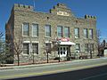
The Esmeralda County courthouse in Goldfield, Nevada.
-
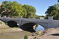
The Humboldt River Bridge, one of the last concrete arch-deck bridges in Nevada.


