
Gommiswald facts for kids
Quick facts for kids
Gommiswald
|
||
|---|---|---|
_218.JPG) |
||
|
||

Gommiswald
Location in Switzerland

Gommiswald
Location in Canton of St. Gallen
|
||
| Country | Switzerland | |
| Canton | St. Gallen | |
| District | See-Gaster | |
| Area | ||
| • Total | 33.59 km2 (12.97 sq mi) | |
| Elevation | 590 m (1,940 ft) | |
| Population
(Dec 2020 )
|
||
| • Total | 5,316 | |
| • Density | 158.26/km2 (409.90/sq mi) | |
| Postal code |
8737
|
|
| Surrounded by | Ebnat-Kappel, Kaltbrunn, Uznach, Wattwil | |

Gommiswald is a municipality (like a town or district) in the canton of St. Gallen, Switzerland. It is located in a region called See-Gaster. On January 1, 2013, the smaller municipalities of Rieden and Ernetschwil joined with Gommiswald to form a larger community.
Contents
History of Gommiswald

Gommiswald was first mentioned in old records in 1178 as Göycheim. Later, in 1440, it was called Göchams gewalt. The main village was known as Gauen until the 1700s.
Both Gauen and Gommiswald were used for a while. In 1913, the government decided that Gommiswald would be the official name.
In the early Middle Ages, a place called Schänis Abbey had the right to collect taxes (called tithes) in Gommiswald. They also had control over the village church. Around 1200, Gommiswald became part of the Toggenburg County of Uznach.
In 1439, after the last Count of Toggenburg died, two Swiss cantons, Schwyz and Glarus, took joint control of Uznach. This is called a joint condominium.
In 1500, the people of Gommiswald built their own church. In 1556, they bought the right to collect tithes from Schänis Abbey. A monastery called Mount Zion Abbey was founded near the village in 1761.
After the French invasion in 1798, the County of Uznach became free from the joint control of Schwyz and Glarus.
New roads were built in 1785-88 and 1830. These roads helped connect Gommiswald to nearby towns. In 1803, Gommiswald and Ernetschwil briefly formed one municipality but separated again in 1807.
Gommiswald did not have much industry until 1932. That year, a cotton factory called Wattefabrik Kistler opened. Since 1960, the population of Gommiswald has grown a lot. It has become a popular place for people to live and visit.
Rieden was first mentioned in 1045 as Rieta. Ernetschwil was first mentioned in 885 as Eidwarteswilare.
Geography of Gommiswald
_289.JPG)
After the merger in 2013, Gommiswald covers an area of about 11.86 square kilometers (4.58 square miles).
Before the merger, about 42.3% of the land was used for farming. Forests covered 49.2% of the area. The remaining land was used for buildings, roads, or was non-productive like rivers.
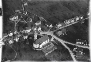
The municipality is located on a high ridge. This ridge is between the Linth valley and the Regelstein valley. Gommiswald includes the main village and smaller settlements called hamlets. These hamlets include Attenbach, Giegen, Ottenhofen, Ramendingen, Schubingen, and Üetliburg.
Gommiswald's Coat of Arms
The blazon (description) of Gommiswald's coat of arms shows a red shield. From the bottom, a golden hand appears with three fingers raised. The hand is wearing a black sleeve with a white cross.
The three raised fingers on the hand show how people traditionally swear oaths in Switzerland. The famous Rütlischwur, which was the founding oath of the Swiss Confederation, also shows people holding up three fingers.
Population and People
_215.JPG)
Gommiswald has a population of about 4,973 people (as of December 2014). About 13.6% of the people living in Gommiswald are from other countries. Most people in Gommiswald speak German (92.1%). Albanian is the second most common language (3.2%), followed by Italian (1.3%).
In 2000, about 14.3% of the population were children aged 0-9. Teenagers aged 10-19 made up 13.6%. Most adults were between 30 and 39 years old (16.9%).
In 2000, about 10.3% of people lived alone. About 23.3% were couples without children. Most people (57.8%) were part of a couple with children.
In the 2007 federal election, the most popular political party was the SVP. It received 46.5% of the votes. Other popular parties included the CVP (22.2%) and the FDP (10.1%).
About 70.6% of adults (aged 25–64) in Gommiswald have finished high school or gone on to higher education. This means they have studied at a university or a specialized college.
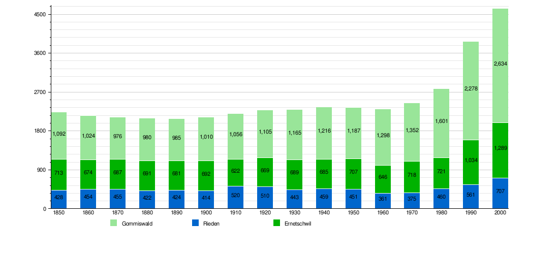
Historic Population
The chart below shows how the population of Gommiswald, Rieden, and Ernetschwil has changed over time:
Economy and Jobs
_240.JPG)
In 2007, the unemployment rate in Gommiswald was low, at 1.27%. This means very few people who wanted jobs couldn't find them.
In 2005, there were 87 people working in the primary economic sector. This sector includes jobs like farming and forestry. There were 37 businesses in this area.
The secondary sector had 322 workers and 27 businesses. This sector includes jobs like manufacturing and construction.
The tertiary sector had 365 workers and 79 businesses. This sector includes jobs in services, like shops, schools, and healthcare.
In 2000, 441 people worked within Gommiswald. However, 881 residents traveled outside Gommiswald for their jobs. Also, 294 people came into Gommiswald to work.
Religion in Gommiswald
According to the 2000 census, most people in Gommiswald are Roman Catholic (65.0%). About 18.4% belong to the Swiss Reformed Church.
A smaller number of people belong to other Christian churches, the Orthodox Church, or Islam. There were also a few people who were Jewish. About 6.99% of the population said they did not belong to any church, or were agnostic or atheist.
Places to See
The Uetliburg/Berg Sion area near Gommiswald village is a special place. It is listed as part of the Inventory of Swiss Heritage Sites, which means it is an important historical or cultural location.
See also
 In Spanish: Gommiswald para niños
