Granite Domes of Yosemite National Park facts for kids
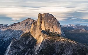
Many granite domes are found in Yosemite National Park. These are huge, rounded rock formations that look like giant bald heads. They are a big part of what makes Yosemite so famous and beautiful. People love to hike and climb on these amazing natural wonders.
What is a Dome's "Clean Prominence"?
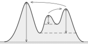
When we talk about how much a mountain or a dome "stands out" from the land around it, we use a term called topographic prominence. Think of it as how tall a dome really is, not just from sea level, but from its base compared to other nearby peaks.
Clean prominence is a special way to measure this. It's the straight up-and-down distance from:
- The very top of the dome, down to
- The lowest point (called a col or saddle) where you could draw a circle around the dome without including any higher land.
To figure out a dome's clean prominence, you need to know:
- The height of the dome's top.
- The height of that lowest connecting point (the col) that circles the dome.

This "clean prominence" helps us understand how much a dome truly rises above its surroundings.
Famous Granite Domes in Yosemite
Yosemite National Park is home to many incredible granite domes. Below is a list of some of these domes. If you know of another dome that should be on this list, you can add it! Some domes are listed in the areas of Tuolumne Meadows or Tenaya Lake, even if they are a bit in between.
The table below lists the domes and some interesting facts about them. The numbers for height and prominence come from the websites listed in the last column.
| Name of Dome | Summit Height | Clean Prominence | County | Region in Yosemite | Web Links |
|---|---|---|---|---|---|
| Basket Dome | 2,320 metres (7,610 ft) | 64 metres (210 ft) | Mariposa County | Yosemite Valley | [1] |
| Daff Dome | 2,790 metres (9,150 ft) | 157 metres (515 ft) | Tuolumne County | Tuolumne Meadows | [2][3] |
| Doda Dome | 2,715 metres (8,907 ft) | 82 metres (269 ft) | Tuolumne County | Tuolumne Meadows | [4][5] |
| Dog Dome | 2,865 metres (9,400 ft) | 24 metres (79 ft) | Tuolumne County | Tuolumne Meadows | [6] |
| Dozier Dome | 2,847 metres (9,341 ft) | 12 metres (39 ft) | Mariposa County | Tenaya Lake | [7][8] |
| Drug Dome | 2,769 metres (9,085 ft) | 0 metres (0 ft) | Mariposa County | Tuolumne Meadows | [9][10] |
| East Cottage Dome, also "Erratic Dome" | 2,780 metres (9,120 ft) | 61 metres (200 ft) | Tuolumne County | Tuolumne Meadows | [11] |
| East Quarter Dome | 2,535 metres (8,317 ft) | 36 metres (118 ft) | Mariposa County | Yosemite Valley | [12] |
| Fairview Dome | 2,964 metres (9,724 ft) | 184 metres (604 ft) | Tuolumne County | Tuolumne Meadows | [13][14] |
| Half Dome | 2,694 metres (8,839 ft) | 415 metres (1,362 ft) | Mariposa County | Yosemite Valley/Little Yosemite Valley | [15][16][17] |
| Hammer Dome | 2,665 metres (8,743 ft) | 56 metres (184 ft) | Tuolumne County | Tuolumne Meadows | [18] |
| Harlequin Dome | 2,710 metres (8,890 ft) | Mariposa County | Tenaya Lake | [19] | |
| Hetch Hetchy Dome | 1,889 metres (6,198 ft) | 72 metres (236 ft) | Tuolumne County | Hetch Hetchy | [20] |
| Kolana Rock | 1,759 metres (5,771 ft) | 192 metres (630 ft) | Mariposa County | Hetch Hetchy | [21] |
| Lamb Dome | 2,806 metres (9,206 ft) | 117 metres (384 ft) | Tuolumne County | Tuolumne Meadows/Tenaya Lake | [22][23] |
| Lembert Dome | 2,880 metres (9,450 ft) | 88 metres (289 ft) | Tuolumne County | Tuolumne Meadows | [24][25] |
| Liberty Cap | 2,157 feet (657 m) | 304 metres (997 ft) | Mariposa County | Little Yosemite Valley | [26][27] |
| Mariolumne Dome | 3,039 metres (9,970 ft) | 143 metres (469 ft) | Tuolumne County | Tuolumne Meadows/Tenaya Lake | [28][29] |
| Marmot Dome | 2,829 metres (9,281 ft) | 13 metres (43 ft) | Tuolumne County | Tuolumne Meadows | [30][31] |
| Medlicott Dome | 3,011 metres (9,879 ft) | 61 metres (200 ft) | Mariposa County/Tuolumne County | Tuolumne Meadows/Tenaya Lake | [32][33] |
| Moraine Dome | 2,440 metres (8,010 ft) | 60 metres (200 ft) | Mariposa County | Little Yosemite Valley | [34] |
| North Dome | 2,299 metres (7,543 ft) | 43 metres (141 ft) | Mariposa County | Yosemite Valley | [35][36] |
| North Whizz Dome | 2,707 metres (8,881 ft) | 37 metres (121 ft) | Tuolumne County | Tuolumne Meadows/Tenaya Lake | [37] |
| Polly Dome | 2,989 metres (9,806 ft) | 331 metres (1,086 ft) | Mariposa County | Tenaya Lake | [38] |
| Pothole Dome | 2,670 metres (8,760 ft) | 12 metres (39 ft) | Tuolumne County | Tuolumne Meadows | [39][40] |
| Puppy Dome | 2,670 metres (8,760 ft) | 24 metres (79 ft) | Tuolumne County | Tuolumne Meadows | [41][42] |
| Pywiack Dome | 2,698 metres (8,852 ft) | 77 metres (253 ft) | Mariposa County | Tenaya Lake | [43][44] |
| SAR Dome | 2,691 metres (8,829 ft) | 76 metres (249 ft) | Tuolumne County | Glen Aulin High Sierra Camp | [45] |
| Scar Dome | 2,697 metres (8,848 ft) | 27 metres (89 ft) | Tuolumne County | Glen Aulin High Sierra Camp | [46] |
| Scary Dome | 2,684 metres (8,806 ft) | 26 metres (85 ft) | Tuolumne County | Glen Aulin High Sierra Camp | [47] |
| Sentinel Dome | 2,476 metres (8,123 ft) | 99 metres (325 ft) | Mariposa County | Glacier Point | [48][49] |
| South Whizz Dome | 2,707 metres (8,881 ft) | 25 metres (82 ft) | Tuolumne County | Tuolumne Meadows | [50] |
| Stately Pleasure Dome | 2,755 metres (9,039 ft) | 0 metres (0 ft) | Mariposa County | Tenaya Lake | [51][52] |
| Sugarloaf Dome | 2,342 metres (7,684 ft) | 99 metres (325 ft) | Mariposa County | Little Yosemite Valley | [53] |
| Turtleback Dome | 1,615 metres (5,299 ft) | 6 metres (20 ft) | Mariposa County | Wildcat Falls | [54] |
| V-Tree Dome | 2,559 metres (8,396 ft) | 47 metres (154 ft) | Tuolumne County | Grand Canyon of the Tuolumne | [55] |
| Wawona Dome | 2,102 metres (6,896 ft) | 17 metres (56 ft) | Mariposa County | Chilnualna Falls | [56] |
| West Cottage Dome | 2,755 metres (9,039 ft) | 12 metres (39 ft) | Tuolumne County | Tuolumne Meadows | [57] |
| West Quarter Dome | 2,487 metres (8,159 ft) | 12 metres (39 ft) | Mariposa County | Little Yosemite Valley | [58] |
 | Toni Morrison |
 | Barack Obama |
 | Martin Luther King Jr. |
 | Ralph Bunche |


