
Grant County, North Dakota facts for kids
Quick facts for kids
Grant County
|
|
|---|---|

|
|

Location within the U.S. state of North Dakota
|
|
 North Dakota's location within the U.S. |
|
| Country | |
| State | |
| Founded | 1916 |
| Named for | Ulysses S. Grant |
| Seat | Carson |
| Largest city | Elgin |
| Area | |
| • Total | 1,666 sq mi (4,310 km2) |
| • Land | 1,659 sq mi (4,300 km2) |
| • Water | 6.8 sq mi (18 km2) 0.4% |
| Population
(2020)
|
|
| • Total | 2,301 |
| • Estimate
(2022)
|
2,243 |
| • Density | 1.3812/sq mi (0.53327/km2) |
| Time zone | UTC−7 (Mountain) |
| • Summer (DST) | UTC−6 (MDT) |
| Congressional district | At-large |
Grant County is a county located in North Dakota, a state in the United States. In 2020, about 2,301 people lived here. The main town, or county seat, is Carson.
Contents
History of Grant County
The land that is now Grant County was once part of Morton County. In 1916, people living in the southwest part of Morton County voted. They decided to create a new county.
This new county was named after Ulysses S. Grant. He was a famous U.S. President from 1869 to 1877. The county government officially started on November 28, 1916. Carson became the county seat. The borders of Grant County have stayed the same since it was created.

Geography and Nature

The Heart River flows through the northern part of Grant County. Cedar Creek flows along the southern border. The county has rolling hills and some isolated taller hills. Waterways have carved out these areas.
The land is somewhat dry, meaning it doesn't get a lot of rain. Some of the land is used for farming. The highest point in the county is about 2,680 feet (817 meters) above sea level. This is near the southwest corner.
Grant County covers a total area of 1,666 square miles (4,315 square kilometers). Most of this is land (1,659 sq mi or 4,297 sq km). About 6.8 square miles (17.6 sq km) is water. Lake Tschida is the biggest body of water in the county. It is a reservoir on the Heart River.
Time Zone
The southwestern part of North Dakota uses Mountain Time. This includes Grant County. Some nearby counties, like Morton County, use Central Time.
Main Roads
 North Dakota Highway 21
 North Dakota Highway 31
 North Dakota Highway 49
Neighboring Counties
- Morton County - to the northeast
- Sioux County - to the south
- Adams County - to the southwest
- Hettinger County - to the west
- Stark County - to the northwest
Protected Natural Areas
- Cedar River National Grassland (part of it)
- Heart Butte River State Game Management Area
- Otter Creek State Game Management Area
- Pretty Rock National Wildlife Refuge
- Sheep Creek Dam State Recreation Area
Lakes and Water Bodies
- Pretty Rock Lake
- Sheep Creek Dam
- Lake Tschida
Population and People
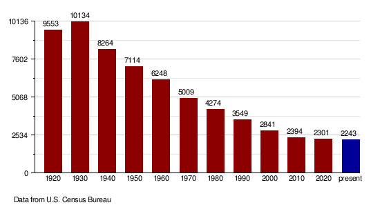
| Historical population | |||
|---|---|---|---|
| Census | Pop. | %± | |
| 1920 | 9,553 | — | |
| 1930 | 10,134 | 6.1% | |
| 1940 | 8,264 | −18.5% | |
| 1950 | 7,114 | −13.9% | |
| 1960 | 6,248 | −12.2% | |
| 1970 | 5,009 | −19.8% | |
| 1980 | 4,274 | −14.7% | |
| 1990 | 3,549 | −17.0% | |
| 2000 | 2,841 | −19.9% | |
| 2010 | 2,394 | −15.7% | |
| 2020 | 2,301 | −3.9% | |
| 2022 (est.) | 2,243 | −6.3% | |
| U.S. Decennial Census 1790-1960 1900-1990 1990-2000 2010-2020 |
|||
Recent Population Counts
In 2020, the census showed that 2,301 people lived in Grant County.
Population Trends Over Time
The population of Grant County has changed over many years. The chart below shows how many people lived in the county during different census years.
Towns and Communities
Grant County has several towns and smaller communities.
Cities
- Carson (the county seat)
- Elgin
- Leith
- New Leipzig
Census-Designated Places
These are areas that are like towns but are not officially incorporated as cities.
Unincorporated Communities
These are smaller places without their own local government.
Townships
Townships are smaller areas within a county, often with their own local government.
- Elm
- Fisher
- Freda
- Howe
- Lark
- Leipzig
- Minnie
- Pretty Rock
- Raleigh
- Rock
- Winona
Former Township
- Otter Creek Township
See also
 In Spanish: Condado de Grant (Dakota del Norte) para niños
