Greater Green River Basin facts for kids
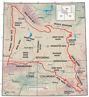
The Greater Green River Basin (GGRB) is a huge area of land, about 21,000 square miles, located in Southwestern Wyoming. Imagine a giant bowl in the Earth's surface – that's kind of what a basin is! This basin was formed a very long time ago, during the Cretaceous period. It holds many valuable resources like natural gas. The GGRB is surrounded by mountains and uplifts, like the Uinta Mountains and the Wind River Range.
The Greater Green River Basin is actually made up of four smaller basins: the Green River Basin, the Great Divide Basin, the Washakie Basin, and the Sand Wash Basin. Each of these smaller areas has its own natural gas and oil, which people have been able to use. In fact, there are over 300 gas fields here, with the Jonah Field being the biggest!
What is the geology of the Greater Green River Basin?
The GGRB was shaped by a long period of mountain building called the Laramide Orogeny. This event created many folds in the Earth's crust, like giant wrinkles. One big wrinkle, called the Rock Springs Uplift, divides the basin into eastern and western parts.
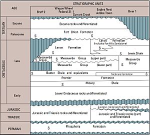
Before the basin fully formed, important rocks were laid down during the Permian period. These rocks, part of the Phosphoria Formation, came from a shallow sea that was rich in phosphorus. This ancient sea helped create the source rocks for much of the oil and gas found in the Rocky Mountains today. The Laramide Orogeny wasn't just one quick event; it was a long process that affected different parts of the GGRB in unique ways. Because the GGRB is so large, each of its smaller basins has its own special geological story.
What is the Rock Springs Uplift?
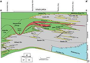
The Rock Springs Uplift is a large, raised area of land, about 1,200 square miles. It's like a big, tilted hill made of rock layers from the Late Cretaceous period. This uplift separates the Green River Basin to the west from the Great Divide, Washakie, and Sand Wash Basins to the east.
Over time, the rocks on top of the uplift have worn away, forming a deep dip surrounded by steep cliffs called escarpments. These cliffs are part of the Mesaverde Group of rocks. Above these cliffs, you can find valleys with other rock layers like the Lewis Shale and the Lance Formation. Even younger rocks from the Paleocene and Eocene periods are also found here. Many of these rocks are soft shales that were laid down in ancient seas.
Exploring the sub-basins
The Greater Green River Basin is divided into four main sub-basins. Each one has its own unique features and history.
Green River Basin: The largest sub-basin
The Green River Basin is the biggest of the four sub-basins, covering about 10,500 square miles. A notable feature here is Oyster Ridge, a long, angled ridge that shows off Cretaceous sandstone rocks. Another important area is White Mountain, which has rocks from the Mid-Eocene period. The edges of the basin are made of gravels and conglomerates (rocks made of different sized pebbles stuck together) from the Tertiary period. Most of the rocks you see in the Green River Basin are from the Eocene period.
Great Divide Basin: On the Continental Divide
The Great Divide Basin is located in the northeastern part of the GGRB. It got its name because it sits right on the Continental Divide, which is like a natural line that separates which way rivers flow across a continent. This basin is about 3,500 square miles. It doesn't have many large rock outcrops. Instead, it's mostly made up of low hills, sand dunes, and dry lakebeds. It's a desert-like area, separated from the Green River Basin by the Rock Springs Uplift.
Washakie Basin: A rimmed basin
The Washakie Basin is a 3,000 square mile basin located in the south-central part of the GGRB, just south of the Great Divide Basin. It's known for its "rimmed" shape, where the edges are about 1,000 feet higher than the center. The higher parts are topped by rocks from the Laney Member of the Green River Formation (Mid-Eocene). Below these, you can see rocks from the Wasatch Formation (Lower Eocene).
Sand Wash Basin: Dipping into Colorado
The Sand Wash Basin is the smallest of the four sub-basins, covering about 2,000 square miles. It's in the southeastern part of the GGRB and even extends into northwestern Colorado. There are a few places in the middle of the basin where Eocene-aged rocks stick out, forming ridges. Like the Washakie Basin, you can find the Laney Member of the Green River Formation and the Wasatch Formation exposed along these ridges.
How do we find oil and gas?
To find oil and gas, geologists look for three main things: source rocks, traps, and seals.
Source rocks: Where oil and gas begin
Source rocks are special rocks that contain the organic material (like tiny ancient plants and animals) that eventually turns into oil and natural gas. The GGRB has many source rocks, but the most important ones are the Permian Phosphoria Formation, the Cretaceous Mowry Shale, and the Cretaceous Mesaverde Group.
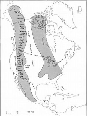
The Cretaceous source rocks are mostly marine shales. These were laid down in a large ancient sea called the Western Interior Seaway. Over time, these shales were buried deep under other sediments. This deep burial, along with heat and pressure, helped turn the organic material into oil and gas. The rocks on top of these shales now act as great places to store the oil and gas.
- Phosphoria Formation: These Permian shales are thought to be the main source for much of the oil in the region. Oil from these shales likely moved into other rock layers, like the Tensleep Sandstone. Oil from the Phosphoria Formation often has a high sulfur content. This is interesting because sulfur-rich oils can form at lower temperatures than other types of oil. The Tensleep Sandstone is a very important reservoir rock, holding about 142 million barrels of oil!
- Mowry Shale: The Mowry Shale is another well-known source rock, especially for oil. It has a very high amount of organic material. It's known to supply oil to other important rock layers like the Dakota Formation and the Frontier Formation. What makes the Mowry Shale special is that it's sealed by other marine shales and the oil and gas are held in place by both folds in the rock (called anticlines) and breaks in the rock (called faults). It's estimated to hold millions of barrels of oil and billions of cubic feet of gas.
- Mesaverde Group: The Mesaverde Group is a major source of natural gas in the GGRB. These rocks were formed during periods when ancient seas moved in and out. Although some parts of the Mesaverde Group have worn away, it's still a fantastic source for gas and a good source for oil. The gas and oil in the Mesaverde Group are mostly sealed by marine shales that lie on top of them. The gas and oil are trapped in different ways, including in anticline traps (rock folds), fault traps (breaks in the rock), and stratigraphic pinch-out traps (where rock layers thin out). The Mesaverde Group is estimated to have huge amounts of gas, making it a key area for gas exploration.
 | Aaron Henry |
 | T. R. M. Howard |
 | Jesse Jackson |


