
Guadalupe River (Texas) facts for kids
Quick facts for kids Guadalupe River |
|
|---|---|

A bluff at Guadalupe River State Park
|
|

Map of the Guadalupe River watershed
|
|
| Other name(s) | Río Guadalupe |
| Country | United States |
| State | Texas |
| Region | Texas Hill Country, Texas Coastal Bend |
| Physical characteristics | |
| Main source | Kerr County, Texas 676 m (2,218 ft) 30°05′17″N 99°38′32″W / 30.08806°N 99.64222°W |
| River mouth | San Antonio Bay, Gulf of Mexico 0 m (0 ft) 28°24′07″N 96°46′57″W / 28.40194°N 96.78250°W |
| Length | 370 km (230 mi) |
| Basin features | |
| Basin size | 17,353 km2 (6,700 sq mi) |
The Guadalupe River is a beautiful waterway in Texas, United States. It starts in Kerr County and flows all the way to San Antonio Bay, which is part of the Gulf of Mexico. This river is a super popular spot for fun activities like rafting, fly fishing, and canoeing.
Many cities are located along the Guadalupe River. These include Kerrville, New Braunfels, Seguin, Gonzales, Cuero, and Victoria. The river also has several dams. The most famous one is Canyon Dam, which creates Canyon Lake near New Braunfels.
Contents
Exploring the Guadalupe River's Journey
The Guadalupe River changes quite a bit along its path. It starts in the Texas Hill Country as a smaller, faster stream. Here, the river banks are made of limestone and are shaded by pecan and bald cypress trees.
Upper Guadalupe River: Fun in the Hill Country
The upper part of the river is formed by two main branches: the North Fork and South Fork Guadalupe Rivers. This area is very popular for "tubing." Tubing means floating down the river on large inflated inner tubes, especially during spring and summer.
East of Boerne, the river flows through Guadalupe River State Park. This park is one of the most popular places for tubing on the river.
Lower Guadalupe River: Recreation and Major Connections
The lower part of the river begins after the water flows out of Canyon Lake, near New Braunfels. The section between Canyon Dam and New Braunfels is used a lot for recreation. It's a favorite spot for whitewater rafters, canoeists, kayakers, and tubers.
When the water flow is low (less than 1,000 cu ft/s (28 m3/s)), you might see thousands of tubes on this part of the river. If the water flows faster (more than 1,000 cu ft/s (28 m3/s)), there will be fewer tubes because it becomes more challenging. Flows between 1,000 cu ft/s (28 m3/s) and 2,500 cu ft/s (71 m3/s) are great for rafting and paddling. The amount of water flowing is controlled by Canyon Dam and by how much rain the area gets.
The Guadalupe River is joined by the Comal River in New Braunfels. Further downstream, it meets the San Marcos River near Gonzales. The part of the river below the San Marcos River is used for the Texas Water Safari, a long paddling race.
The San Antonio River also flows into the Guadalupe River near Tivoli. Before reaching the San Antonio Bay estuary, the Guadalupe River forms a delta. This means it splits into two smaller rivers, called distributaries, known as the North and South parts. Both of these flow into Guadalupe Bay, which is part of the San Antonio Bay estuary.
History of the Guadalupe River
The Guadalupe River has a long and interesting history. In 1689, Alonso de León first named the river after Nuestra Señora de Guadalupe. Later, Domingo Terán de los Ríos tried to rename it San Augustin, but the name Guadalupe stuck.
For thousands of years, different Native American groups lived along the river. These included the Karankawa, Tonkawa, and Huaco (pronounced like Waco) tribes.
Early Settlers and a Brave Crossing
In the mid-1800s, a group of 228 German immigrants, led by Prince Solms, traveled from Indianola to start the first German settlement in Texas, which became New Braunfels. When they reached the Guadalupe River, it was too high to cross because of heavy winter rains.
Prince Solms bravely rode his horse into the strong current and crossed the swollen river. Not to be outdone, Betty Holekamp immediately followed him and successfully crossed too. Because of her courage, Betty Holekamp is known as the first white woman to cross the Guadalupe River on horseback.
The 1987 Flood: A Story of Danger and Rescue
On July 17, 1987, a sudden flash flood happened near Comfort, Texas. A bus full of children was swept away at a low water crossing. A church camp was taking place at the Pot O' Gold Ranch, located on the river. Heavy rains had caused the Guadalupe River to flood.
Camp supervisors decided to evacuate the children early. While most buses made it across, one bus carrying 39 children and 4 adults was caught in the floodwaters. Luckily, the Army's 507th Medical Division used helicopters to rescue all four adults and 29 of the children.
In 1988, a memorial plaque was placed near the river to remember those who were affected by the flood. The story of the flood and rescues was even shown on the TV show Rescue 911 and made into a movie called The Flood: Who Will Save Our Children? in 1993. This event reminds us how powerful and dangerous floods can be.
Fishing in the Guadalupe River
The Guadalupe River is a fantastic place for fishing! Below Canyon Lake, fly fishing for rainbow trout and brown trout is very popular. Anglers (people who fish) can also catch many other types of fish, including:
Fishing is also common below many of the weirs (small dams), spillways, and dams along the river. For example, you can find good fishing spots below the West-point Pepperell Dam near New Braunfels.
Understanding River Conditions and Flow
The Guadalupe River's conditions can change very quickly. The flow (how fast the water is moving) is controlled by the dam at Canyon Lake. The Army Corps of Engineers manages this to help keep people safe.
However, the river can still experience severe flooding. During rainy seasons, the water can rise very high and become extremely dangerous due to strong currents. If the flow gauge at Sattler Gage goes above 1,000 cubic feet per second (28 m3/s), local authorities usually consider it too dangerous for most recreational activities. Only expert kayakers or whitewater rafters might be able to handle it then. For example, on October 31, 2013, the river in New Braunfels rose from 74 to 33,500 cubic feet per second (2.1 to 948.6 m3/s) in just over an hour because of heavy local rainfall! This shows how important it is to always check river conditions before you go.
Points of Interest Along the River
- Riverside Nature Center, Kerrville, Texas
Images for kids
-
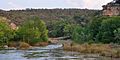
The Guadalupe River in Kerr County, Texas, USA (8 May 2014).
-
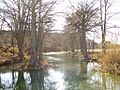
The Guadalupe River in Gruene
-
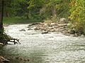
The Guadalupe River near Hunt
-

The Guadalupe River under Interstate 35 in New Braunfels
-
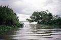
Mouth of the South Guadalupe River at Guadalupe Bay
.jpg)


See also
 In Spanish: Río Guadalupe (Texas) para niños
