Guadiana facts for kids
Quick facts for kids Guadiana River |
|
|---|---|
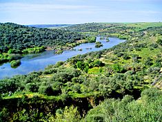
The Guadiana River in the area around Serpa, Portugal
|
|
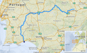
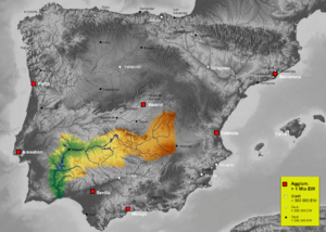
About 83 percent, 55,000 square kilometres (21,000 sq mi), of the River Guadiana watershed is in Spain; the rest is in Portugal (interactive map)
|
|
| Other name(s) | Rio Guadiana |
| Country | Spain and Portugal |
| Physical characteristics | |
| Main source | Ojos del Guadiana Villarrubia de los Ojos, Castile–La Mancha, Spain 608 m (1,995 ft) 39°7′36″N 3°43′36″W / 39.12667°N 3.72667°W |
| River mouth | Gulf of Cádiz Vila Real de Santo António, Algarve, Portugal 0 m (0 ft) 37°10′12″N 7°23′37″W / 37.17000°N 7.39361°W |
| Length | 818 km (508 mi) |
| Depth |
|
| Basin features | |
| Basin size | 67,733 km2 (26,152 sq mi) |
| Tributaries |
|
The Guadiana River is a very important international river in Europe. It forms a long part of the border between Portugal and Spain. This river separates regions like Extremadura and Andalusia in Spain from Alentejo and Algarve in Portugal.
The Guadiana River and its smaller rivers (tributaries) flow from east to west. Then, they turn south through Portugal. Finally, the river reaches the Gulf of Cádiz, which is part of the Atlantic Ocean. This happens near the towns of Vila Real de Santo António in Portugal and Ayamonte in Spain.
The Guadiana River is about 829 kilometres (515 mi) long. This makes it the fourth-longest river on the Iberian peninsula. Its entire river system, called a hydrological basin, covers an area of about 68,000 square kilometres (26,000 sq mi). Most of this area is located within Spain.
Contents
What's in a Name? The Guadiana's History
The name of the Guadiana River has changed over many years. When the Romans were in charge, they called it Flumen Anas. This means "River of Ducks."
Later, when the Moors lived in the area, they called it Wadi Ana. Wadi is an Arabic word for "river." Over time, the name changed again. Portuguese and Spanish settlers started calling it Ouadiana, and then just Odiana.
Since the 1500s, the name slowly became Guadiana. This name is similar to other rivers in the area that start with "Guad-", like the Guadalquivir or Guadalete. These names often show their Arabic roots.
Where the Guadiana Flows: Its Journey and Basin
The Guadiana River starts in Spain and flows from east to west. Then, it turns south as it enters Portugal. For a long stretch, it forms the border between Spain and Portugal. Finally, it empties into the Gulf of Cádiz, which is part of the Atlantic Ocean. This happens between Vila Real de Santo António in Portugal and Ayamonte in Spain.
The river is about 818 kilometres (508 mi) long. About 578 kilometres (359 mi) of its length is in Spain. About 140 kilometres (87 mi) is in Portugal. The remaining 100 kilometres (62 mi) forms the border between the two countries. Most of the land that drains into the Guadiana (its basin) is in Spain. About 82% of the basin is in Spain, while 17% is in Portugal.
Where Does the River Start? Exploring Its Sources
The exact starting point of the Guadiana River in Castilla-La Mancha, Spain, is a bit of a mystery. However, most people believe it begins at a place called the Ojos del Guadiana (which means "Eyes of the Guadiana"). This spot is in the town of Villarrubia de los Ojos, in the Ciudad Real Province, Spain. It is about 608 metres (1,995 ft) above sea level.
For a long time, people thought the river came from the Lagunas de Ruidera lakes. They believed it then went underground and reappeared later. This idea was even written about by Pliny the Elder, a famous Roman writer. This led to the legend that the river would sometimes disappear and then show up again. However, scientists now know there isn't a hidden underground river. Also, the idea that the Lagunas de Ruidera is the main source is still debated.
Another idea is that the Cigüela and Záncara rivers are the true sources. Today, these rivers are seen as very important parts of the Guadiana's upper section. They are major rivers that feed into the Guadiana system. The Cigüela River starts in the mountains of Altos de Cabreras, about 1,080 metres (3,540 ft) high. It flows for 225 kilometres (140 mi). The joining of the Cigüela and Záncara rivers helps fill the Tablas de Daimiel National Park. This is a special wetland protected by the Spanish government since 1973.
The River's Path: From Source to Sea
From its starting point, the Guadiana flows across the southern Iberian peninsula from east to west. When it gets close to the city of Badajoz, it turns south. This southern path leads it towards the Gulf of Cádiz.
The Guadiana forms the border between Spain and Portugal in two main sections. First, it marks the border between the River Caia and Ribeira de Cuncos. Then, it forms the border again from the River Chança all the way to its mouth. The river doesn't mark the entire border, though. There's a small area between the Olivenza ravine and the Táliga ravine where the border is still discussed by both countries. Spain currently manages this area.
Most of the Guadiana River is easy to travel by boat from the Atlantic Ocean up to Mértola. This is a distance of about 68 kilometres (42 mi). North of Mértola, you can find the highest waterfall in Southern Portugal, called Pulo do Lobo.
The river's environment is like the Mediterranean climate. This means the amount of water flowing in the river changes a lot. There can be big floods or very dry periods. This is because the rainfall varies a lot, usually between 400 to 600 millimetres (16 to 24 in) per year. The climate is also semi-arid, meaning it's quite dry. The average yearly temperature is between 14 to 16 °C (57 to 61 °F).
Where the River Meets the Sea: The Estuary
The Guadiana River flows into the Gulf of Cádiz between Ayamonte in Spain and Vila Real de Santo António in Portugal. These two areas are popular for tourists. At its mouth, the river forms a saltmarsh estuary. An estuary is where a river meets the sea, and fresh water mixes with salty ocean water.
The widest part of the estuary is about 550 metres (1,800 ft). Its depth can range from 5 to 17 metres (16 to 56 ft). The tides here go up and down twice a day, changing the water level by 0.8 to 3.5 metres (2.6 to 11.5 ft). These tides can reach about 76 kilometres (47 mi) upriver from the mouth.
The lower part of the estuary has important nature reserves. In Spain, there's the Marismas de Isla Cristina. In Portugal, there's the Reserva Natural do Sapal de Castro Marim e Vila Real de Santo António. These reserves protect the natural environment and are very important for wildlife.
How People Use the Guadiana: Human Impact
The Guadiana River flows through many different areas. In Spain, it crosses three regions: Castilla-La Mancha, Extremadura, and Andalusia. These include the provinces of Ciudad Real, Badajoz, and Huelva. In Portugal, the river goes through the regions of Alentejo and Algarve. It also passes through the districts of Portalegre, Évora, Beja, and Faro.
Dams Along the River
There are more than 30 dams built across the Guadiana River basin. Dams help control water flow, provide water for farming, and generate electricity. Here are some of the main dams directly on the Guadiana River:
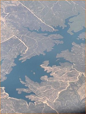
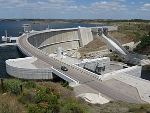
- Alqueva Dam: This is the largest dam on the river. It's located near Moura in Portugal. It creates the biggest reservoir (a large artificial lake) in Western Europe. The Alqueva reservoir covers an area of 250 square kilometres (97 sq mi) and can hold a huge amount of water, about 4,150 cubic hectometres (3,360,000 acre⋅ft).
- García Sola Reservoir
- Cíjara Reservoir
- El Vicario Reservoir
- Orellana Reservoir
See also
 In Spanish: Guadiana para niños
 | William Lucy |
 | Charles Hayes |
 | Cleveland Robinson |


