Gulf Hammock (wetlands) facts for kids
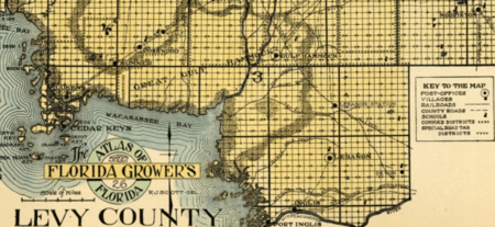
Gulf Hammock is a large area of wetlands in the southern part of Levy County, Florida. It stretches along the Gulf of Mexico coast from Cedar Key down to the Withlacoochee River. It also reaches several miles inland. This area has the biggest stretch of a special type of forest called hydric hammock in Florida. Most of Gulf Hammock is not lived in by people. The part closest to the Gulf coast is a state park. The areas further inland are mainly used for cutting down trees and for hunting.
Contents
Exploring the Gulf Hammock Area
Gulf Hammock is located along the Gulf of Mexico. It sits between Cedar Key and the Withlacoochee River. It includes land southwest of U.S. Highway 19-98 and south of Florida State Road 24. This area is part of a chain of similar forests. This chain is known as the Gulf Hammock Belt. It runs along Florida's Big Bend Coast.
Long ago, Gulf Hammock covered over 40,000 hectares (about 100,000 acres) in Levy County. But its size has shrunk a lot. This is because some land was turned into farms or pine tree farms. The Waccasassa Bay Preserve State Park protects about 34,000 acres (13,700 hectares) of this coastal area. This includes 19,000 acres (7,700 hectares) of tidal marshes. The Gulf Hammock Wildlife Management Area is another large part. It covers more than 24,000 acres (9,700 hectares). This land is owned by companies that harvest timber. Much of the rest of Gulf Hammock is also owned by these timber companies.
The land in Gulf Hammock is mostly flat and low. It is usually less than 25 feet (7.6 meters) above sea level. However, there are some old sand dunes inland from Cedar Key that are a bit higher. The ground here has limestone very close to the surface. The water level underground is also very close to the surface. The part of the hammock in the Waccasassa Bay Preserve State Park is usually less than 5 feet (1.5 meters) above sea level. Some small islands or mounds rise up to 10 feet (3 meters). The top layer of soil is thin, sitting over limestone.
More than 40 named streams flow through Gulf Hammock. The Waccasassa River flows right through the middle. The Wekiva River (also called Wekiva Creek) flows into the Waccasassa River. It passes through the small community of Gulf Hammock. Other streams like Otter Creek and Cow Creek also feed the Waccasassa River. Dry Creek is the biggest stream that flows directly into the Gulf of Mexico. The hammock also has slow-moving waterways called sloughs.
During the rainy season, from June to September, the ground is often soaked. The sloughs may flood. After heavy rains, like from hurricanes, much of the hammock can be underwater. In the driest months (November, April, and May), streams and sloughs often stop flowing. The soil in higher areas can dry out completely.
Plant Life in Gulf Hammock
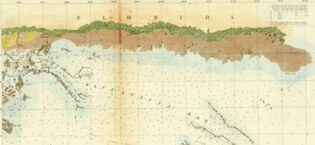
Gulf Hammock is separated from the Gulf of Mexico by a salt marsh. This marsh is mostly covered by a plant called black rush. It has tidal creeks and ponds. It is almost completely covered by water during spring high tides. In 1950, this salt marsh zone was about 1 to 3 miles (1.6 to 4.8 kilometers) wide.
The sea level at Cedar Key has been rising. It goes up about 0.15 centimeters (0.06 inches) each year since 1939. Because of this rising sea level, the salt marsh has moved inland. It has advanced about 1 kilometer (0.6 miles) along the coast between 1858 and 1995.
Further inland from the salt marsh are the coastal hammock and coastal savanna areas. These areas are a bit higher than the salt marsh. But they can still get flooded with salt water sometimes. Coastal hammocks have many cabbage palms, red cedars, and live oak trees. Coastal savannas have low-growing plants that can handle salt. They also have a few cabbage palms.
Even further inland are swamps, hydric hammocks, and mesic hammocks. The trees in these areas are mostly evergreen hardwood trees. Many tree species grow in all three areas. But how many of each kind, and where they grow, helps tell the areas apart. Swamps are flooded most of the time. Hydric hammocks might be flooded for part of the year. Mesic hammocks are on drier, slightly higher ground.
Beyond the swamps and hammocks are flatwoods. Slash pine flatwoods grow on low, poorly drained land. Longleaf pine flatwoods are on higher, better-drained ground. Cypress ponds are small dips in the flatwoods that hold water almost all year. They are home to both bald cypress and pond cypress trees. Hydric hammocks also grow along rivers and streams that flow through the flatwoods. However, they have fewer types of trees than the larger hammocks. Sand pine scrub grows on the old sand dunes.
People and History in Gulf Hammock
Native Americans lived in Gulf Hammock long before Europeans arrived. One study found 37 archaeological sites from the Weeden Island period (300 to 1200 AD). Eighty archaeological sites have been found within the Waccasassa Bay Preserve State Park. Most of these are shell mounds. This park covers about one-third of the historic Gulf Hammock area. Many of these mounds are wearing away. One reason is rising sea levels. Many mounds that were once on higher ground are now surrounded by water. Other old Native American sites are probably now covered by water too.
Clarence Bloomfield Moore, an archaeologist, visited several mounds in Gulf Hammock around the late 1800s and early 1900s. He reached these mounds from Dry Creek and the Waccasassa River. All the mounds he saw had been disturbed. Some were plowed, but most were dug up by people looking for things. Moore said one mound had been dug up many times. He found burials and old tools in some mounds, but nothing in others. In the 1990s, tools found at two sites in Gulf Hammock showed that people lived there even earlier. This was during the late Paleoindian or early Archaic periods.
During the Second Seminole War, the U.S. Army built forts in northern Florida. This was to stop the Seminole people from moving around. Fort Three was built at the mouth of the Waccasassa River. But no signs of this fort have ever been found.
Local stories said that a salt works used to operate in Gulf Hammock. Archaeologists found the remains of a small salt works on Salt Island. This island is next to Salt Creek in the hammock. Salt Island is a small rise in the limestone base within the salt marsh. It supports a hydric hammock. The remains included a couple of furnaces and broken pieces of kettles. These are probably from the mid-to-late 1800s. It seems this site did not make a lot of salt. Today, the part of Gulf Hammock that is in the Waccasassa Bay Preserve State Park has no people living in it.
Logging and Timber in Gulf Hammock
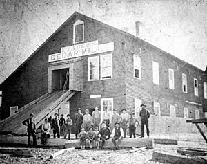
Large-scale logging began in Gulf Hammock after the American Civil War. In 1865, the Eberhard Faber pencil company built a mill in Cedar Key. They cut southern red cedar trees (Juniperus virginiana) into slats. These slats were then sent to New York City to be made into pencils. Soon after, the Eagle Pencil Company built its own mill in Cedar Key for the same purpose. Many of the red cedar trees used by these mills came from Gulf Hammock.
By the 1890s, too many red cedar trees had been cut down. Production started to drop. In 1896, a hurricane hit the area. It knocked down many red cedar trees in Gulf Hammock and along the coast. The Eagle Pencil Company mill was destroyed. The Eberhard Faber mill lost a lot of cedar slats and uncut timber. This was a loss of about $40,000. The Eberhard Faber mill was repaired after the storm. But it closed just two years later because there wasn't enough cedar wood left. Cutting too many red cedar trees in Gulf Hammock in the late 1800s had long-lasting effects. Even a century later, large tree stumps were still there. New trees had not yet grown as big as those old stumps.
Hardwood trees from the hydric hammocks were also cut. These were used for making furniture and crates in the late 1800s and early 1900s. Even by the late 1900s, new trees in the remote parts of Gulf Hammock had not grown as large as the old ones. Before the 1900s, logging was usually selective. This means only trees with the highest market value were cut.
In the first half of the 1900s, a practice called highgrading became common. This meant cutting all trees that had a market value at the time. Less desirable trees were left standing. In the later half of the 1900s, clearcutting became the standard. This means cutting down all trees in an area. These practices changed the types of trees found in the hammocks. Sometimes, the hammocks were left to grow back on their own. But many clearcut areas were planted with loblolly pine trees.
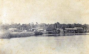
Cabbage palms were also cut down in the 1800s. They were used as pilings, which are strong posts driven into the ground. Later in the 1800s, cabbage palms were harvested for their fiber. The leaf bud of the palm was cut off, which killed the tree. These buds were then processed to make a fiber used in brooms and brushes. The Royal Brush and Broom Company had a palm fiber factory in the community of Gulf Hammock in the late 1800s and early 1900s. The Standard Manufacturing Company ran a fiber factory in Cedar Key from 1910 to 1950. Cabbage trees were taken from along the coast, from the Suwannee River to the Chassahowitzka River. Gulf Hammock was right in the middle of this area.
 | Shirley Ann Jackson |
 | Garett Morgan |
 | J. Ernest Wilkins Jr. |
 | Elijah McCoy |


