Guttenberg, New Jersey facts for kids
Quick facts for kids
Guttenberg, New Jersey
|
||
|---|---|---|
|
Town
|
||
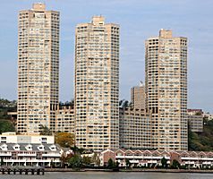
The Galaxy Towers from the Hudson River
|
||
|
||
| Country | ||
| State | ||
| County | ||
| Incorporated | March 9, 1859 | |
| Named for | Johannes Gutenberg | |
| Government | ||
| • Type | Town | |
| • Body | Town Council | |
| Area | ||
| • Total | 0.24 sq mi (0.62 km2) | |
| • Land | 0.19 sq mi (0.50 km2) | |
| • Water | 0.05 sq mi (0.12 km2) 20.00% | |
| Area rank | 557th of 565 in state 11th of 12 in county |
|
| Elevation | 194 ft (59 m) | |
| Population
(2020)
|
||
| • Total | 12,017 | |
| • Estimate
(2023)
|
11,365 | |
| • Rank | 211th of 565 in state 11th of 12 in county |
|
| • Density | 62,264.2/sq mi (24,040.3/km2) | |
| • Density rank | 1st of 565 in state 1st of 12 in county |
|
| Time zone | UTC−05:00 (Eastern (EST)) | |
| • Summer (DST) | UTC−04:00 (Eastern (EDT)) | |
| ZIP Code |
07093
|
|
| Area code(s) | 201 | |
| FIPS code | 3401728650 | |
| GNIS feature ID | 0885235 | |
Guttenberg (/ˈɡʌtənbɜːrɡ/ gut-ƏN-burg) is a small town in the northern part of Hudson County, New Jersey. It is known for being one of the most crowded places in the United States. In 2020, it was the most densely populated town in the country.
Guttenberg is very narrow, only about four blocks wide from north to south. It is one of the smallest towns in New Jersey. In 2020, about 12,017 people lived there. Many people live in the Galaxy Towers, which are tall buildings overlooking the Hudson River.
Contents
History of Guttenberg
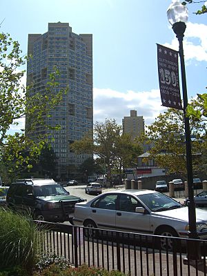
Guttenberg started as a farm owned by William Cooper. In 1853, a group from New York bought the land. They formed the Weehawken Land and Ferry Association. They sold smaller pieces of land, mostly to German families.
The town was officially created on March 9, 1859. It was first part of North Bergen Township. Later, it became part of Union Township. Guttenberg became fully independent on April 1, 1878. The town is named after Johannes Gutenberg. He invented the printing press in Europe. Some people also think the name means "good village" in German.
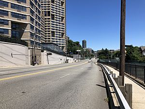
The Galaxy Towers were built in the late 1970s. These three tall buildings are 415 feet high. They have 1,075 apartments inside.
Where is Guttenberg Located?
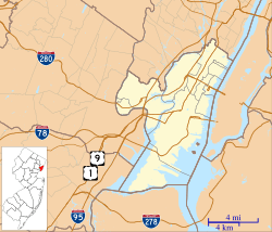
Guttenberg is on top of the Hudson Palisades. It is south of North Bergen and north of West New York. To the east, it borders Manhattan in New York City across the Hudson River. Its western border is Kennedy Boulevard.
Bergenline Avenue runs through the town. This street is a busy area for shops in North Hudson. It is sometimes called "Havana on the Hudson" because of its vibrant culture.
The town covers about 0.24 square miles (0.62 square kilometers). Most of this is land, with a small part being water. It is so small that you can drive through it in less than a minute.
Population and People
| Historical population | |||
|---|---|---|---|
| Census | Pop. | %± | |
| 1880 | 1,206 | — | |
| 1890 | 1,927 | 59.8% | |
| 1900 | 3,825 | 98.5% | |
| 1910 | 5,647 | 47.6% | |
| 1920 | 6,726 | 19.1% | |
| 1930 | 6,535 | −2.8% | |
| 1940 | 6,200 | −5.1% | |
| 1950 | 5,566 | −10.2% | |
| 1960 | 5,118 | −8.0% | |
| 1970 | 5,754 | 12.4% | |
| 1980 | 7,340 | 27.6% | |
| 1990 | 8,268 | 12.6% | |
| 2000 | 10,807 | 30.7% | |
| 2010 | 11,176 | 3.4% | |
| 2020 | 12,017 | 7.5% | |
| 2023 (est.) | 11,365 | 1.7% | |
| Population sources: 1880–1920 1880–1890 1890–1910 1910–1930 1940–2000 2000 2010 2020 |
|||
Population in 2010
In 2010, Guttenberg had 11,176 people living there. The town was very crowded, with about 57,116 people per square mile. Most residents were White (67.44%), with smaller groups of Black (4.80%), Native American (0.91%), and Asian (7.32%) people. Many residents (64.83%) were of Hispanic or Latino background.
About 20.5% of the people were under 18 years old. The average age in Guttenberg was 36.4 years.
Population in 2000
In 2000, there were 10,807 people in Guttenberg. It was the most densely populated town in the United States. About 21.2% of the population was under 18. The average age was 36 years.
Many people who live in Guttenberg work in New York City. About 36% of the working residents commute to Manhattan.
Economy and Business
Guttenberg has a special area called an Urban Enterprise Zone (UEZ). This zone helps businesses grow and create jobs. It offers benefits like a lower sales tax rate. Shoppers in this zone pay only 3.3125% sales tax, which is half the usual state rate. Guttenberg became a UEZ in May 1996, and this status will continue until May 2027.
The UEZ includes several streets:
- Bergenline Avenue (from 68th to 71st Street)
- Park Avenue (from 68th to 71st Street)
- 70th Street (from Park Avenue to Bergenline Avenue)
- 69th Street (from Park Avenue to Boulevard East)
- Parts of 69th to 71st Street on Boulevard East
- Parts of 70th to 71st Street on Broadway
Local Government
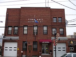
Guttenberg has a "Town" style of government. The town is led by a Mayor and a five-member Town Council. All these leaders are chosen by voters in elections. The Mayor is elected directly by the people. Town Council members serve four-year terms.
As of 2022, the Mayor of Guttenberg is Wayne D. Zitt Jr. He is a Democrat, and his term ends on December 31, 2025. The current Town Council members are Richard Delafuente, Monica Fundora, John D. Habermann, William Hokien, and Juana Malave.
In the past, some leaders in Guttenberg faced issues related to their roles. For example, in 2008, a former mayor and his wife were found to have acted improperly. Another former mayor also admitted to misusing campaign money in 2003. These situations led to changes in leadership.
Education in Guttenberg
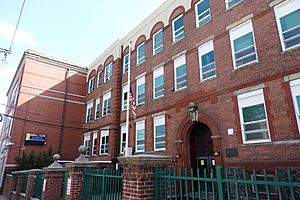
Students in Guttenberg attend the Anna L. Klein School for pre-kindergarten through eighth grade. This is part of the Guttenberg Public School District. In the 2021–22 school year, the school had 920 students. There was about one teacher for every 9.9 students. The principal of Anna L. Klein School is Keith Petry.
For high school, students from Guttenberg go to North Bergen High School in North Bergen. This is part of a special agreement with the North Bergen School District. In the 2021–22 school year, North Bergen High School had 2,316 students.
Transportation Options
As of 2015, Guttenberg has about 4.39 miles of roads. Most of these roads are managed by the town itself.
The main roads in Guttenberg are county highways. County Route 501 runs along the western edge of town on Kennedy Boulevard. County Route 505 follows River Road on the east side. Both of these roads go north and south. Boulevard East also goes through the town on top of the Palisades.
Major highways like Interstate 95 (the New Jersey Turnpike), U.S. Route 1/9, and New Jersey Route 495 are nearby in North Bergen.
Public Transit
NJ Transit (NJT) offers bus services from Guttenberg. You can take a bus to the Port Authority Bus Terminal in Midtown Manhattan or to places in Bergen County. There are also local bus services within Hudson County. Private jitney services also help people get around.
You can also take a ferry to West Midtown Ferry Terminal in Manhattan. This service is provided by NY Waterway. Ferry stops are located south at Weehawken Port Imperial and north at Edgewater Landing.
Famous People from Guttenberg
Many interesting people have lived in or were born in Guttenberg, including:
- Troy Archer (1955–1979), a football player for the New York Giants.
- Steve Carell (born 1962), a famous actor from TV shows like The Daily Show. He lived in Guttenberg for a time.
- Melissa Fumero (born 1982), an actress known for her roles in Brooklyn Nine-Nine and One Life to Live.
- Joseph Rudolph Grimes (1923–2007), a politician who served as the Minister of Foreign Affairs for Liberia.
- Stephen Ledogar (1929–2010), an ambassador and diplomat.
- William Oberhardt (1882–1958), an artist who was a portrait painter and sculptor.
- John Scarne (1903–1985), a magician and author known for his card tricks.
- Jane C. Wright (1919–2013), a pioneering doctor who researched cancer and chemotherapy.
See also
 In Spanish: Guttenberg (Nueva Jersey) para niños
 | James B. Knighten |
 | Azellia White |
 | Willa Brown |


