Hachiōji facts for kids
Quick facts for kids
Hachiōji
八王子市
|
|||||||||||||
|---|---|---|---|---|---|---|---|---|---|---|---|---|---|
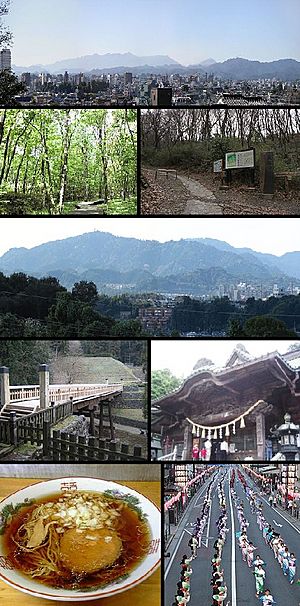
View of top left, Downtown Hachioji, Komiya Park, Naganuma Park, Mount Takao, stone fence and bridge in Hachioji Castle site, Yakuoin in Mount Takao, Hachioji Ramen, Hachioji Traditional Festival on August
|
|||||||||||||
|
|||||||||||||
 |
|||||||||||||
| Country | Japan | ||||||||||||
| Region | Kantō | ||||||||||||
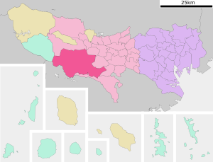
| Prefecture | Tokyo | ||||||||||||
| First official recorded | 3rd century AD (official) | ||||||||||||
| Town settled | April 1, 1889 | ||||||||||||
| City settled | September 1, 1917 | ||||||||||||
| Area | |||||||||||||
| • Total | 186.38 km2 (71.96 sq mi) | ||||||||||||
| Population
(March 2021)
|
|||||||||||||
| • Total | 561,344 | ||||||||||||
| • Density | 3,011.83/km2 (7,800.59/sq mi) | ||||||||||||
| Time zone | UTC+9 (Japan Standard Time) | ||||||||||||
| Phone number | 042-626-3111 | ||||||||||||
| Address | 3-24-1 Motohongo-cho, Hachiōji-shi, Tokyo 192-8501 | ||||||||||||
| Climate | Cfa | ||||||||||||
|
|||||||||||||
Hachiōji (八王子市, Hachiōji-shi) is a large city in the western part of Tokyo Metropolis, Japan. As of March 2021, about 561,344 people lived there. This makes it the most populated city in Tokyo outside of the main central areas. The city covers an area of about 186.38 square kilometers (72 square miles).
Contents
Geography of Hachiōji
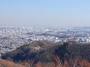
Hachiōji is located in the western part of Tokyo, about 40 kilometers (25 miles) west of central Tokyo. It sits at the base of the Okutama Mountains. The city is surrounded by mountains on three sides, forming a basin that opens up towards Tokyo in the east.
Mountains and natural spots
The mountains to the southwest include Mount Takao, which is 599 meters (1,965 feet) high. Another popular spot is Mount Jinba, standing at 857 meters (2,812 feet). Both mountains are great for hiking and can be reached easily by train or bus.
Neighboring towns and cities
Hachiōji shares its borders with several other cities and towns.
- In Tokyo Metropolis:
- Machida
- Tama
- Fussa
- Hino
- Akishima
- Akiruno
- Hinohara
- In Kanagawa Prefecture:
Climate in Hachiōji
Hachiōji has a humid subtropical climate. This means it has warm summers and cool winters. There is usually light or no snowfall. The average temperature for the year is about 13.9°C (57°F). September is the wettest month, with a lot of rain. The hottest month is August, and the coldest is January.
| Climate data for Hachioji (1991−2020 normals, extremes 1976−present) | |||||||||||||
|---|---|---|---|---|---|---|---|---|---|---|---|---|---|
| Month | Jan | Feb | Mar | Apr | May | Jun | Jul | Aug | Sep | Oct | Nov | Dec | Year |
| Record high °C (°F) | 19.9 (67.8) |
24.0 (75.2) |
26.6 (79.9) |
32.2 (90.0) |
37.1 (98.8) |
36.0 (96.8) |
39.3 (102.7) |
39.3 (102.7) |
39.2 (102.6) |
32.7 (90.9) |
26.7 (80.1) |
26.0 (78.8) |
39.3 (102.7) |
| Mean daily maximum °C (°F) | 9.3 (48.7) |
10.3 (50.5) |
13.7 (56.7) |
19.1 (66.4) |
23.6 (74.5) |
26.0 (78.8) |
30.1 (86.2) |
31.4 (88.5) |
27.1 (80.8) |
21.5 (70.7) |
16.4 (61.5) |
11.7 (53.1) |
20.0 (68.0) |
| Daily mean °C (°F) | 3.4 (38.1) |
4.5 (40.1) |
8.0 (46.4) |
13.3 (55.9) |
18.1 (64.6) |
21.4 (70.5) |
25.4 (77.7) |
26.4 (79.5) |
22.6 (72.7) |
16.9 (62.4) |
11.1 (52.0) |
5.9 (42.6) |
14.7 (58.5) |
| Mean daily minimum °C (°F) | −1.8 (28.8) |
−0.9 (30.4) |
2.7 (36.9) |
7.7 (45.9) |
12.9 (55.2) |
17.4 (63.3) |
21.5 (70.7) |
22.4 (72.3) |
18.8 (65.8) |
13.0 (55.4) |
6.4 (43.5) |
0.8 (33.4) |
10.1 (50.2) |
| Record low °C (°F) | −8.7 (16.3) |
−8.8 (16.2) |
−8.1 (17.4) |
−2.0 (28.4) |
2.6 (36.7) |
10.0 (50.0) |
13.3 (55.9) |
15.4 (59.7) |
7.9 (46.2) |
2.4 (36.3) |
−2.3 (27.9) |
−7.6 (18.3) |
−8.8 (16.2) |
| Average precipitation mm (inches) | 54.1 (2.13) |
46.1 (1.81) |
102.9 (4.05) |
114.1 (4.49) |
124.7 (4.91) |
172.0 (6.77) |
188.3 (7.41) |
212.5 (8.37) |
264.4 (10.41) |
230.8 (9.09) |
80.1 (3.15) |
53.1 (2.09) |
1,643 (64.69) |
| Average precipitation days (≥ 1.0 mm) | 4.5 | 4.9 | 9.2 | 9.2 | 10.0 | 12.7 | 12.5 | 10.4 | 12.2 | 10.5 | 7.2 | 4.9 | 108.2 |
| Mean monthly sunshine hours | 201.1 | 179.7 | 174.9 | 179.3 | 176.0 | 119.7 | 145.1 | 177.3 | 128.0 | 132.4 | 157.0 | 184.2 | 1,954.5 |
| Source: JMA | |||||||||||||
Population Growth in Hachiōji
The number of people living in Hachiōji has grown a lot over the last 90 years. Recently, the population has stayed about the same.
| Historical population | ||
|---|---|---|
| Year | Pop. | ±% |
| 1920 | 78,705 | — |
| 1930 | 95,389 | +21.2% |
| 1940 | 111,028 | +16.4% |
| 1950 | 131,470 | +18.4% |
| 1960 | 164,622 | +25.2% |
| 1970 | 253,407 | +53.9% |
| 1980 | 387,178 | +52.8% |
| 1990 | 466,347 | +20.4% |
| 2000 | 536,046 | +14.9% |
| 2010 | 580,053 | +8.2% |
| 2020 | 579,355 | −0.1% |
History of Hachiōji
The area where Hachiōji is today has a long history. It was once part of an old Japanese province called Musashi Province. For a long time, it was an important stop along the Kōshū Kaidō. This was a main road connecting Edo (which is now Tokyo) with western Japan.
Castles and old times
Hachiōji Castle was built in 1584 during a time of many wars in Japan, known as the Sengoku period. A powerful leader named Hōjō Ujiteru built it. However, the castle was destroyed in 1590 by another famous leader, Toyotomi Hideyoshi. Later, during the Edo period, the area was directly controlled by the Tokugawa shogunate, Japan's military government.
Becoming a modern city
In 1889, Hachiōji became a town. Then, on September 1, 1917, it officially became a city. This was part of Japan's move to create modern towns and cities. In 2015, Hachiōji became a "Core city," which means it gained more local control over its own affairs.
Hachiōji and the Olympics
Hachiōji played a part in the 1964 Summer Olympics! The city hosted the road cycling events. There was also a special track for cycling, called a velodrome, where other cycling races took place.
Economy and Jobs in Hachiōji
In the past, during the Meiji period, Hachiōji was famous for making silk and silk fabrics. This industry was very important to the city's economy. However, by the 1960s, the silk industry slowly disappeared.
Today, Hachiōji is mostly a commuter town. This means many people who live here travel to Tokyo for work. The city is also home to many large colleges and universities, making education a big part of its economy.
Education in Hachiōji
Hachiōji is a major center for education, with many schools and universities.
Colleges and universities
The city has many well-known universities and colleges, including:
- Chuo University (Tama Campus)
- Digital Hollywood University
- Kogakuin University (Hachioji Campus)
- Kyorin University (Hachioji Campus)
- Meisei University (Hino Campus)
- Nihon Bunka University
- Soka University
- Tama Art University (Hachioji Campus)
- Takushoku University (Hachioji Campus)
- Teikyo University (Hachioji Campus)
- Tokyo Junshin University
- Tokyo Kasei-Gakuin University (Machida Campus)
- Tokyo Metropolitan University (Minamiōsawa Campus)
- Tokyo University of Agriculture and Technology
- Tokyo University of Pharmacy and Life Sciences
- Tokyo University of Technology (Hachiōji Campus)
- Tokyo Zokei University
- Nippon Engineering College
- Hachioji Municipal Nursing College
High schools
The Tokyo Metropolitan Government runs nine public high schools in Hachiōji. There is also a special school for the blind. In addition, there are eleven private high schools.
Some of the public high schools include:
- Minamitama Secondary Education School (junior and senior high)
- Fujimori High School
- Hachioji Higashi High School
- Hachioji Kita High School
- Hachioji Soshi High School
- Hachioji Takushin High School
- Katakura High School
- Matsugaya High School
- Shoyo High School
Elementary and junior high schools
The city government of Hachiōji operates many public elementary and junior high schools. There are 70 public elementary schools and 37 public junior high schools. There are also four schools that combine both elementary and junior high levels.
Transportation in Hachiōji
Hachiōji is a busy city with many ways to get around, especially by train.
Train lines
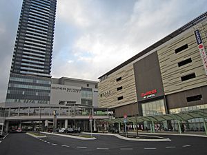
Several train companies and lines serve Hachiōji, connecting it to Tokyo and other parts of Japan.
 JR East - Chūō Main Line
- Hachiōji – Nishi-Hachiōji – Takao
 JR East - Yokohama Line
- Hachiōji-Minamino – Katakura – Hachiōji
 JR East - Hachikō Line
- Hachiōji – Kita-Hachiōji – Komiya
 Keio Corporation - Keiō Line
- Naganuma – Kitano – Keiō-Hachiōji
 Keio Corporation - Keiō Takao Line
- Kitano – Keiō-Katakura – Yamada – Mejirodai – Hazama – Takao – Takaosanguchi
 Keio Corporation - Sagamihara Line
- Keiō-Horinouchi – Minami-Ōsawa
 Tokyo Tama Intercity Monorail - Tama Toshi Monorail Line
- Chūō-Daigaku-Meisei-Daigaku – Ōtsuka-Teikyō-Daigaku – Matsugaya
- Takaotozan Railway
Major highways
Several important highways pass through Hachiōji, making it easy to travel by car.
 Ken-Ō Expressway
 Chūō Expressway
 National Route 16
 National Route 20
 National Route 411
Sister Cities of Hachiōji
Hachiōji has special "friendship city" relationships with other cities around the world. These relationships help promote cultural exchange and understanding.
 Kaohsiung, Taiwan (since November 1, 2006)
 Siheung, Gyeonggi Province, South Korea (since November 7, 2006)
 Tai'an, Shandong, People's Republic of China (since September 23, 2006)
Fun Places to Visit in Hachiōji
Hachiōji is a large city with many different areas. You can find busy city centers with shops, and also quiet, natural areas in the west.
- Mt. Takao (599 m) is a very popular place for hiking. You can easily get there using the Keiō Takao Line. It's also famous for a Buddhist temple called Takao-san Yakuōin Yūkiji (高尾山薬王院有喜寺).
- Mt. Jinba (855 m) is a bit harder to reach, requiring a bus ride. But it's worth it for the amazing view of Mt. Fuji on a clear day!
- Tama Forest Science Garden is a great place to learn about trees and nature.
- Tokyo Fuji Art Museum has many beautiful artworks to explore.
- Musashi Imperial Graveyard is a special place where two Japanese emperors, Taishō and Shōwa, are buried.
- Takiyama Castle and Hachiōji Castle are old castle ruins from the Sengoku period. They are important historical sites and are listed among Japan's top castles.
Images for kids
-
The sign at the top of Mount Takao.
See also
 In Spanish: Hachiōji (Tokio) para niños


