
Hagan Mountain facts for kids
Quick facts for kids Hagan Mountain |
|
|---|---|

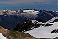
Hagan Mountain seen from northwest
|
|
| Highest point | |
| Elevation | 7,080+ ft (2,160+ m) |
| Prominence | 600 ft (180 m) |
| Parent peak | Mount Blum 7,685 ft (2342 m) |
| Geography | |

Hagan Mountain
Location in Washington (state)

Hagan Mountain
Location in the United States
|
|
| Parent range | North Cascades Cascade Range |
| Topo map | USGS Damnation Peak |
| Type of rock | phyllite |
| Climbing | |
| Easiest route | Scrambling class 3 and glacier travel |
Hagan Mountain is a tall mountain with several peaks in Washington state. It stands about 7,080 feet (2,158 meters) high. You can find it in the North Cascades mountain range, specifically in Whatcom County. The mountain is inside North Cascades National Park, about 12 miles (19 km) north of a town called Marblemount.
Nearby, Mount Blum is a bit taller, about 1.81 miles (2.91 km) to the north. To the south, Bacon Peak is about 4.45 miles (7.16 km) away. Hagan Mountain has two glaciers, the large Hagan Glacier and the smaller Hidden Creek Glacier. Water from these glaciers and rain flows into streams that eventually join the Skagit River.
Mountain Weather and Climate
Hagan Mountain is in a "marine west coast" climate zone. This means it gets a lot of moisture from the nearby Pacific Ocean. Most weather systems come from the Pacific and move northeast.
When these weather systems reach the Cascade Mountains, the tall peaks force the air upward. As the air rises, it cools and drops its moisture as rain or snow. This process is called Orographic lift. Because of this, the western side of the North Cascades gets a lot of rain and snow, especially in winter.
The climate here is mild. Temperatures rarely go below 0°F (-18°C) or above 80°F (27°C). Winters are usually cloudy. However, in summer, high pressure systems over the Pacific Ocean often bring clear skies. Because the ocean influences the weather, the snow tends to be wet and heavy. This can lead to a high risk of avalanches.
How the Mountains Were Formed
The North Cascades area has very rugged land. You can see sharp peaks, long ridges, and deep valleys carved by glaciers. These amazing shapes and big changes in height were created by geological events over millions of years. These events also led to the different climates you find across the Cascade Range.

The Cascade Mountains started forming millions of years ago, during a time called the late Eocene Epoch. This happened because the North American Plate was slowly moving over the Pacific Plate. This movement caused a lot of volcanic activity. Also, small pieces of the Earth's crust, called terranes, came together to form the North Cascades about 50 million years ago.
Later, during the Pleistocene period (which began over two million years ago), huge sheets of ice called glaciers moved across the land many times. These glaciers carved out the "U"-shaped valleys you see today. The combination of land being pushed up (called orogeny) and cracks forming in the Earth's crust (called faulting), along with the glaciers, created the tall peaks and deep valleys of the North Cascades.
Images for kids
-
Northwest aspect

